
Seeley Lake is an unincorporated community and census-designated place (CDP) in Missoula County, Montana, United States. It is part of the Missoula metropolitan area. The town sits beside the 1,030-acre (420 ha) Seeley Lake. The population was 1,682 at the 2020 census.

The Flathead Indian Reservation, located in western Montana on the Flathead River, is home to the Bitterroot Salish, Kootenai, and Pend d'Oreilles tribes – also known as the Confederated Salish and Kootenai Tribes of the Flathead Nation. The reservation, often referred to as the Flathead Nation, or simply Flathead or by its official acronym C.S.K.T., was created through the July 16, 1855, Treaty of Hellgate.

The Flathead National Forest is a national forest in the western part of the U.S. state of Montana. The forest lies primarily in Flathead County, south of Glacier National Park. The forest covers 2,404,935 acres of which about 1 million acres (4,000 km2) is designated wilderness. It is named after the Flathead Native Americans who live in the area.

The Beaverhead–Deerlodge National Forest is the largest of the National Forests in Montana, United States. Covering 3.36 million acres (13,600 km2), the forest is broken into nine separate sections and stretches across eight counties in the southwestern area of the state. President Theodore Roosevelt named the two forests in 1908 and they were merged in 1996. Forest headquarters are located in Dillon, Montana. In Roosevelt's original legislation, the Deerlodge National Forest was called the Big Hole Forest Reserve. He created this reserve because the Anaconda Copper Mining Company, based in Butte, Montana, had begun to clearcut the upper Big Hole River watershed. The subsequent erosion, exacerbated by smoke pollution from the Anaconda smelter, was devastating the region. Ranchers and conservationists alike complained to Roosevelt, who made several trips to the area. (Munday 2001)

Bitterroot National Forest comprises 1.587 million acres (6,423 km2) in west-central Montana and eastern Idaho of the United States. It is located primarily in Ravalli County, Montana, but also has acreage in Idaho County, Idaho (29.24%), and Missoula County, Montana (0.49%).

Lolo National Forest is a national forest located in western Montana, United States with the western boundary being the state of Idaho. The forest spans 2 million acres (8,000 km2) and includes four wilderness areas; the Scapegoat and the Selway-Bitterroot Wilderness are partially within the forest while the Welcome Creek and Rattlesnake Wildernesses are solely in Lolo National Forest. The forest was created in 1906 from 4 different previous forests which were combined for administrative purposes. Lolo National Forest is west of the Continental divide and has a biodiversity influenced by both continental and maritime weather creating a transitional forest that has a high number of different plant and tree species.

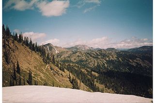
The Mission Mountains or Mission Range are a range of the Rocky Mountains located in northwestern Montana in the United States. They lie chiefly in Lake County and Missoula County and are south and east of Flathead Lake and west of the Swan Range. On the east side of the range is the Swan River Valley and on the west side the Mission Valley.

The Tobacco Root Mountains lie in the northern Rocky Mountains, between the Jefferson and Madison Rivers in southwest Montana. The highest peak is Hollowtop at 10,604 feet (3,232 m). The range contains 43 peaks rising to elevations greater than 10,000 feet (3048 m).
The Montana Legacy Project is a three-phase purchase of more than 310,000 acres (1,300 km2) of land owned by Plum Creek Timber in northwestern Montana for conservation protection. The land is within the counties of Missoula, Mineral, Lake and Powell.
The John Long Mountains, el. 7,923 feet (2,415 m), is a small mountain range northwest of Philipsburg, Montana in Granite County, Montana. The Beaverhead-Deerlodge National Forest and Lolo National Forest manage these mountains. A sizable roadless area of about 65,000 acres existed, as of 1990, in the John Long Mountains, centered on Silver King Mountain in the southern part of the range. It's unknown whether and to what extent this area's size has been reduced by logging. Lightly used trails traverse whitebark pine forests on the higher ridges, and forests of lodgepole pine, Douglas-fir, and heavy downfall on the eastern slopes. The western slopes have groves of douglas-fir amidst extensive grassy parks. Silver King Mountain is 7,581'.
The Rattlesnake Mountains are a prominent mountain range located just 4 miles north of Missoula, Montana, USA. The highest point in the range is McLeod Peak,. Much of the range is protected in the Rattlesnake Wilderness and Rattlesnake National Recreation Area on the Lolo National Forest. An additional 36,000 acres (15,000 ha) of the range are protected on the Flathead Indian Reservation as the South Fork Tribal Primitive Area; this area is off-limits to non-tribal members. Including the Tribal Primitive Area, then, about 100,000 acres (40,000 ha) of the Rattlesnakes are roadless.
Camp Paxson Boy Scout Camp, located on the western shore of Seeley Lake, Lolo National Forest, Montana, is on the National Register of Historic Places. It started out as a summer camp for the Boy Scouts of America (BSA), and is named in honor of Montana western painter Edgar Samuel Paxson. The United States Forest Service granted the Western Montana Council of the BSA permission to build a summer camp, originally with six small 12x24' clapboard structures and tents on just 4 acres (1.6 ha), in 1924. The camp was expanded beginning in October 1939, with more facilities constructed by the Works Progress Administration and Civilian Conservation Corps (CCC). The camp was completed in 1940 on 6.7 acres (2.7 ha) under the supervision of Forest Service engineer Clyde Fickes.

U.S. Highway 93 is a north–south United States Numbered Highway in the state of Montana.

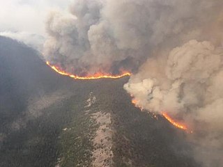
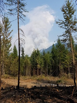
The Rice Ridge Fire was a wildfire that burned northeast of Seeley Lake in the Lolo National Forest in Montana in the United States. The fire, which was started by a lightning strike on July 24, 2017, became a megafire on September 3, growing from 40,000 acres (162 km2) to over 100,000 acres (405 km2), at which time it became the nation’s top wildfire priority as of early September 2017. Located north and east of Seeley Lake, Montana, over 700 firefighting personnel were assigned to the blaze, primarily active in a mountainous lodgepole and mixed conifer forest. The fire had burned 155,900 acres (631 km2) and at one point threatened over 1,000 homes in Powell County and Missoula County including the town of Seeley Lake, Montana and areas north of Highway 200, east of Highway 83. Evacuation orders included parts of Powell County north of Montana Highway 200, areas east of Montana Highway 83, and evacuation warnings for other sections of the forest within Missoula County.

The Reef Fire was a wildfire that was started by a lightning strike and took place in the Bob Marshall Wilderness in Montana in the United States, near Count Peak. The fire, which was reported on August 13, 2017, burned more than 10,658 acres (43 km2) and was contained by October 1, 2017. Instead, it wound up merging with the Rice Ridge Fire.

The Lolo Peak Fire was a wildfire in Lolo National Forest and Bitterroot National Forest, Montana in the United States, that began by lightning strikes on the western flank of Lolo Peak, 10 miles southwest of Lolo, Montana on July 15, 2017. The fire burned a total of 53,902 acres (218 km2). One firefighter, Brent Witham, was killed working the fire, and another firefighter was injured. Two homes were destroyed, over 3,000 people were evacuated and 1,150 residences were threatened. The fire threatened homes along Highway 12 and Highway 93, impacting recreational activities in the area and the communities of Lolo and Florence.

The Conrow Fire was a wildfire that burned seven miles northeast of Whitehall in the Beaverhead–Deerlodge National Forest in Montana in the United States. The fire was started by a lightning strike on August 24, 2017. It has burned 2,741 acres (11 km2) and has threatened homes, ranches and mining operations in the area.
The Meyers Fire burned in Beaverhead-Deerlodge National Forest and Bitterroot National Forest in the U.S. state of Montana and was first reported on July 17, 2017 at 5:21pm. Located approximately 25 mi (40 km) southwest of Phillipsburg, Montana, the Meyers Fire is a natural fire that was caused by lightning. As of September 28, 2017, it encompassed 62,034 acres (25,104 ha). The Meyers Fire originated after a lightning storm passed over the region, starting a fire in remote terrain in Granite County, Montana within Beaverhead-Deerlodge National Forest. The fire then burned into neighboring Ravalli County, Montana and then crossed the continental divide into Beaverhead County, Montana and Deer Lodge County, Montana, where it entered Bitterroot National Forest. By August 3, the Meyers and Whetstone Fires merged, with the name of the former being the official name of the event. Due to a heavy fuel load, exceptionally dry conditions with high heat and periods of strong winds, the Meyers Fire had periods of explosive growth during August and early September, leading to evacuations of nearby communities.
The Gibralter Fire was a wildfire in Kootenai National Forest, 7 miles (11 km) east of Eureka, Montana in the United States. The fire, which was started by a lightning strike, was reported on August 7, 2017, and burned a total of 12,938 acres (52 km2). The fire threatened numerous private property and structures, as well as recreational and historical sites in the forest.


