Meyers Fire

Last updated
Meyers Fire
Meyers Fire.jpg
Meyers Fire August 28, 2017
Location Beaverhead-Deerlodge National Forest and Bitterroot National Forest, Montana, United States
Coordinates 45°59′42″N113°34′48″W / 45.995°N 113.58°W / 45.995; -113.58 [1]
Statistics
Date(s) Started July 17, 2017
5:21pm
Burned area 62,034 acres (25,104 ha)
Cause Lightning
Land use Forest
Buildings
destroyed
0
Fatalities 0
Non-fatal injuries 0

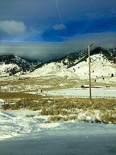
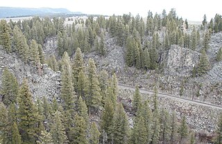
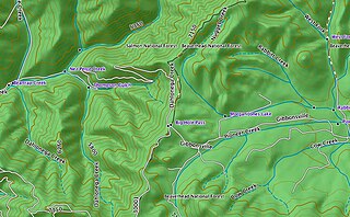
The Meyers Fire burned in Beaverhead-Deerlodge National Forest and Bitterroot National Forest in the U.S. state of Montana and was first reported on July 17, 2017 at 5:21pm. Located approximately 25 mi (40 km) southwest of Phillipsburg, Montana, the Meyers Fire is a natural fire that was caused by lightning. As of September 28, 2017, it encompassed 62,034 acres (25,104 ha). [1] The Meyers Fire originated after a lightning storm passed over the region, starting a fire in remote terrain in Granite County, Montana within Beaverhead-Deerlodge National Forest. The fire then burned into neighboring Ravalli County, Montana and then crossed the continental divide into Beaverhead County, Montana and Deer Lodge County, Montana, where it entered Bitterroot National Forest. [1] By August 3, the Meyers and Whetstone Fires merged, with the name of the former being the official name of the event. [2] Due to a heavy fuel load, exceptionally dry conditions with high heat and periods of strong winds, the Meyers Fire had periods of explosive growth during August and early September, leading to evacuations of nearby communities. [1]

Beaverhead-Deerlodge National Forest forest in Montana, United States

The Beaverhead-Deerlodge National Forest is the largest of the National Forests in Montana, United States. Covering 3.36 million acres (13,600 km2), the forest is broken into nine separate sections and stretches across eight counties in the southwestern area of the state. President Theodore Roosevelt named the two forests in 1908 and they were merged in 1996. Forest headquarters are located in Dillon, Montana. In Roosevelt's original legislation, the Deerlodge National Forest was called the Big Hole Forest Reserve. He created this reserve because the Anaconda Copper Mining Company, based in Butte, Montana, had begun to clearcut the upper Big Hole River watershed. The subsequent erosion, exacerbated by smoke pollution from the Anaconda smelter, was devastating the region. Ranchers and conservationists alike complained to Roosevelt, who made several trips to the area. (Munday 2001)

Bitterroot National Forest

Bitterroot National Forest comprises 1.587 million acres (6,423 km²) in west-central Montana and eastern Idaho, of the United States. It is located primarily in Ravalli County, Montana, but also has acreage in Idaho County, Idaho (29.24%), and Missoula County, Montana (0.49%).

U.S. state constituent political entity of the United States

In the United States, a state is a constituent political entity, of which there are currently 50. Bound together in a political union, each state holds governmental jurisdiction over a separate and defined geographic territory and shares its sovereignty with the federal government. Due to this shared sovereignty, Americans are citizens both of the federal republic and of the state in which they reside. State citizenship and residency are flexible, and no government approval is required to move between states, except for persons restricted by certain types of court orders. Four states use the term commonwealth rather than state in their full official names.

Related Research Articles

Ravalli County, Montana County in the United States

Ravalli County is a county in the southwestern part of the U.S. state of Montana. As of the 2010 United States Census, the population was 40,212. Its county seat is Hamilton.

Bitterroot Range mountain range

The Bitterroot Range is a mountain range and a subrange of the Rocky Mountains that runs along the border of Montana and Idaho in the northwestern United States. The range spans an area of 24,223 square miles (62,740 km2) and is named after the bitterroot, a small pink flower that is the state flower of Montana.

Cameron, Montana human settlement in United States of America

Cameron is an unincorporated community in Madison County, Montana, in the United States.

Great Fire of 1910

The Great Fire of 1910 was a wildfire in the western United States that burned three million acres in North Idaho and Western Montana, with extensions into Eastern Washington and Southeast British Columbia, in the summer of 1910. The area burned included large parts of the Bitterroot, Cabinet, Clearwater, Coeur d'Alene, Flathead, Kaniksu, Kootenai, Lewis and Clark, Lolo, and St. Joe National Forests.

Anaconda-Pintler Wilderness

The Anaconda-Pintler Wilderness is located in southwestern Montana, in the northwestern United States. It runs for 40 miles (65 km) along both sides of the crest of the Anaconda Range, covering almost 250 square miles (640 km2). To the north are the Sapphire Mountains, and to the south is the Big Hole Valley. Elevations range from about 5000 feet up to 10,793 feet at West Goat Peak. West Pintler Peak, located in a more commonly visited area, rises to 9894 feet. Visitors can most easily access this area via trailheads at Pintler Lake to the south, and at Lutz Creek and Moose Lake to the north. The wilderness lies in parts of Deer Lodge, Granite, Ravalli, and Beaverhead counties.

Monida Pass

Monida Pass is a high mountain pass in the Rocky Mountains of the northwestern United States, at an elevation of 6820 ft above sea level on the Union Pacific Railroad and 6870 ft on adjacent Interstate 15.

Big Hole Pass

Big Hole Pass is a high mountain pass on the Montana Idaho border approximately 8 miles due south of Montana State Highway 43 in the Beaverhead-Deerlodge National Forest, Beaverhead County, Montana and Salmon National Forest, Lemhi County, Idaho. This location should not be confused with a sign on Montana Highway 278 at the height of land west of Dillon, Montana that denotes the eastern entrance to the Big Hole valley. The Continental Divide Trail goes over this pass which is about 11 miles south southeast of the more famous Chief Joseph Pass. The Pass can be approached on a Forest Service road, Dahlonega Creek Road (079), from the west, or Forest Service Road #943 from Highway 43 from the east. On their return trip the Lewis & Clark Expedition separated at Travelers Rest in Idaho. On July 3, 1806, Meriwether Lewis headed north to explore the Marias River while William Clark headed up the Bitterroot River with 50 men, Sacagawea and her baby. They crossed Big Hole Pass on their way to their cache of supplies at Camp Fortunate.

Big Hole National Forest was established as the Big Hole Forest Reserve by the U.S. Forest Service in Montana and Idaho on November 5, 1906 with 1,917,100 acres (7,758 km2). It became a National Forest on March 4, 1907. On July 1, 1908 Big Hole was divided between Beaverhead, Deerlodge and Bitterroot National Forests and the name was discontinued.

Hell Gate National Forest was established as the Hell Gate Forest Reserve by the U.S. Forest Service in Montana on October 3, 1905 with 1,581,120 acres (6,398.6 km2). It became a National Forest on March 4, 1907. On July 1, 1908 the entire forest was divided between Beaverhead, Deerlodge, Missoula and Bitterroot National Forests and the name was discontinued.

Madison National Forest was established as the Madison Forest Reserve by the General Land Office in Montana on August 16, 1902 with 736,000 acres (2,980 km2). After the transfer of federal forests to the U.S. Forest Service in 1905, it became a National Forest on March 4, 1907. On December 16, 1931 Madison was divided between Beaverhead, Gallatin and Deerlodge National Forests and the name was discontinued.

Hilgard Peak mountain in United States of America

Hilgard Peak is the tallest mountain in the Madison Range in the U.S. state of Montana. The summit is located in a remote section of the Lee Metcalf Wilderness within the Beaverhead-Deerlodge National Forest. The peak was first climbed in 1948. The peak was named for E. W. Hilgard, a geology professor who served on the Hayden Expedition during its exploration of the Yellowstone area.

Beaverhead Mountains

The Beaverhead Mountains, highest point Scott Peak, el. 11,393 feet (3,473 m), are a mountain range straddling the Continental Divide in the U.S. states of Montana and Idaho. They are a sub-range of the Bitterroot Range, and divide Beaverhead County, Montana from Lemhi County, Idaho and Clark County, Idaho.

Black Butte (Madison County, Montana)

Black Butte, el. 10,547 feet (3,215 m) is the highest peak in the Gravelly Range in Madison County, Montana. The eastern base of the peak is less than 1 mile (1.6 km) from the Beaverhead-Deerlodge National Forest road #290.

Table Mountain (Madison County, Montana) highest peak in the Highland Mountains in Madison County, Montana

Table Mountain, el. 10,213 feet (3,113 m) is the highest peak in the Highland Mountains in Madison County, Montana. It is located in Beaverhead-Deerlodge National Forest. Headwaters of Moose Creek, Fish Creek and Hell's Canyon Creek, all significant tributaries of the Jefferson River flow off the face of the mountain.

Lolo Peak Fire

The Lolo Peak Fire was a wildfire in Lolo National Forest and Bitterroot National Forest, Montana in the United States, that began by lightning strikes on the western flank of Lolo Peak, 10 miles north of Lolo, Montana on July 15, 2017. The fire burned a total of 53,902 acres (218 km2). One firefighter, Brent Witham, was killed working the fire, and another firefighter was injured. Two homes have been destroyed, over 3,000 people were evacuated and 1,150 residences were threatened. The fire threatened homes along Highway 12 and Highway 93, impacting recreational activities in the area and the communities of Lolo and Florence.

2017 Montana wildfires

The 2017 Montana wildfires were a series of wildfires that burned over the course of 2017.

Conrow Fire

The Conrow Fire is a wildfire currently burning seven miles northeast of Whitehall in the Beaverhead-Deerlodge National Forest in Montana in the United States. The fire was started by a lightning strike on August 24, 2017. It has burned 2,741 acres (11 km2) and has threatened homes, ranches and mining operations in the area.

References

  1. 1 2 3 4 "Meyers Fire". InciWeb Incident Information System. Retrieved September 28, 2017.
  2. Rafferty, Melissa (August 3, 2017). "Firefighters make progress on Meyers Fire". KTVQ News. Retrieved September 28, 2017.