The Alice Creek Historic District is a historic district in the Lincoln Ranger District of Helena National Forest, Lincoln, Montana, Lewis and Clark County, Montana. Lichenometry was used for the process of nominating it for inclusion on the National Register of Historic Places; "rock cairns, stone forts, fire hearths, and a Celtic cross" were found as a result. There are no buildings within the historic district. There is a marshy area at the bottom of Alice Creek, sage flats, and many trees.

The Young Fire was a wildfire in the Siskiyou Wilderness in California in the United States. The fire was reported on August 7, 2017. The cause of the fire is currently unknown. As of August 28, the fire had burned 2,650 acres (11 km2) and been added to the Eclipse Complex Fires. By September 1, the Young Fire entirely merged into the Oak Fire.

The Eagle Creek Fire was a destructive wildfire in the Columbia River Gorge in the U.S. states of Oregon and Washington. The fire was started on September 2, 2017, by a 15-year-old boy igniting fireworks during a burn ban. The fire burned 50,000 acres, and burned for three months, before being declared completely contained. As of May 29, 2018 it was found still smoldering in some areas.

The Rice Ridge Fire was a wildfire that burned northeast of Seeley Lake in the Lolo National Forest in Montana in the United States. The fire, which was started by a lightning strike on July 24, 2017, became a megafire on September 3, growing from 40,000 acres (162 km2) to over 100,000 acres (405 km2), at which time it became the nation’s top wildfire priority as of early September 2017. Located north and east of Seeley Lake, Montana, over 700 firefighting personnel were assigned to the blaze, primarily active in a mountainous lodgepole and mixed conifer forest. The fire had burned 155,900 acres (631 km2) and at one point threatened over 1,000 homes in Powell County and Missoula County including the town of Seeley Lake, Montana and areas north of Highway 200, east of Highway 83. Evacuation orders included parts of Powell County north of Montana Highway 200, areas east of Montana Highway 83, and evacuation warnings for other sections of the forest within Missoula County.

The Bearskin Fire was a wildfire in Valley County, Idaho in the United States, 21 miles northeast of Lowman. The fire, which was reported on August 23, 2017, burned a total of 30,251 acres (122 km2).

The Reef Fire is a wildfire currently burning in the Bob Marshall Wilderness in Montana in the United States, near Count Peak. The fire, which was reported on August 13, 2017, has burned a total of 10,658 acres (43 km2) thus far and expected to be contained by October 1, 2017. The fire was started by a lightning strike.

The Lolo Peak Fire was a wildfire in Lolo National Forest and Bitterroot National Forest, Montana in the United States, that began by lightning strikes on the western flank of Lolo Peak, 10 miles north of Lolo, Montana on July 15, 2017. The fire burned a total of 53,902 acres (218 km2). One firefighter, Brent Witham, was killed working the fire, and another firefighter was injured. Two homes have been destroyed, over 3,000 people were evacuated and 1,150 residences were threatened. The fire threatened homes along Highway 12 and Highway 93, impacting recreational activities in the area and the communities of Lolo and Florence.

The Pier Fire was a wildfire that burned near Springville and in the Sequoia National Forest, in California in the United States. The fire was reported on August 29, 2017. The cause of the fire is under investigation, but is believed to be human-caused. The fire was completely extinguished on November 29, after it had burned 36,556 acres (148 km2). The fire threatened old growth sequoia trees, the Tule River Indian Reservation, and many small communities in the area.

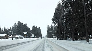
The Alice Creek Fire is a wildfire currently burning north of Lincoln in the Lewis and Clark National Forest, located in Lewis and Clark County in Montana in the United States. The fire, started by a lightning strike, was reported on July 22, 2017. The fire has burned 29,252 acres (118 km2) and four buildings have been destroyed. The fire impacts communities in the surrounding area, with mandatory evacuations in place. The Alice Creek Fire has crossed the Continental Divide, impacting wildlife, specifically aquatic life, and is threatening the Alice Creek Historic District. Additionally, hunting in the area surrounding the fire has been limited.

The High Cascades Complex was a group of 20 fires burning in four protected areas in Oregon, in the United States, specifically: Crater Lake National Park, Rogue River – Siskiyou National Forest, Umpqua National Forest, and Fremont–Winema National Forest. The first fire in the complex, the Blanket Creek Fire, was started by a lightning strike on July 29, 2017. In total, the fires have burned 72,309 acres (293 km2) and are 28% contained. The fires are directly impacting the communities of Prospect, Union Creek and Diamond Lake, park headquarters, old growth forests that house endangered species like the spotted owl and volcanic features.

The Nash Fire is a wildfire that occurred in the Deschutes National Forest and Willamette National Forest, on the southwest slope of the South Sister Mountain in Oregon in the United States. The fire, which was started by lightning, started on August 10, 2017. The Nash Fire was part of the Horse Creek Complex but for reporting purposes was removed from the complex by authorities. The fire threatened the campgrounds and structures at Elk Lake, Hosmer Lake, Lava Lake, and Little Lava Lake.

The Jones Fire was a wildfire in the Willamette National Forest, approximately 10 miles northeast of Lowell, in Oregon in the United States. The fire, which was first reported on August 10, 2017, burned a total of 10,114 acres (41 km2) and was started by lightning. The fire threatened the community of Lowell and distributed various activities in the park, including the start of deer hunting season.

The Whitewater Fire was a wildfire in and near the Mount Jefferson Wilderness, approximately 13 miles east of Detroit, Oregon, United States. The fire, which was caused by a lightning strike and first reported on July 23, 2017, has burned approximately 14,500 acres (59 km2) and is currently no longer active. It is one of eight fires to burn in Willamette National Forest in the Fall of 2017.

The Gibralter Fire was a wildfire in Kootenai National Forest, seven miles east of Eureka, Montana in the United States. The fire, which was started by a lightning strike, was reported on August 7, 2017, and burned a total of 12,938 acres (52 km2). The fire threatened numerous private property and structures, as well as recreational and historical sites in the forest.

The Uno Peak Fire was a wildfire on the slopes of Lake Chelan, approximately 15 miles from Manson, Washington in the United States. The human caused fire was started on August 30, 2017. The fire burned a total of 8,726 acres (35 km2).

The 416 & Burro Fire Complex are active wildfires in the southwestern portion of Colorado in the United States. The fires are predominately within San Juan National Forest, 13 miles north of Durango and 14 miles south of Rico. The 416 fire started on June 1, 2018 and the Burro Fire followed on June 8th. The causes are still under investigation, although it is widely speculated that embers emitted from a coal locomotive used by the Durango and Silverton Narrow Gauge Railroad may have started the blaze. As of July 2, 2018 the fires have burned a combined total of over 55,000 acres (22,258 ha) and have cost more than $27 million to contain. It is one of the largest wildfires in Colorado's history and has had major impacts on tourism and commerce for communities in the southwest portion of the state.

The Trail Mountain Fire was a wildfire burning in Manti-La Sal National Forest fifteen miles northwest of Orangeville, Utah in the United States. The fire was started on June 6, 2018, after the Trail Mountain Prescribed Fire escaped due to high winds. As of June 27, the fire has burned 17,767 acres (72 km2) and is 80 percent contained.

The Georges Fire was a wildfire in Inyo County, California in the United States. The fire was reported on July 8, 2018 in a rural area north of Lone Pine and west of Manzanar. The fire was started by a lightning strike and impacted recreational activities in the Inyo National Forest, as well as the habitat for Sierra Nevada bighorn sheep, an endangered species. The fire burned 2,883 acres (12 km2), before burning out on July 18.

The Ferguson Fire was a wildfire in the Sierra National Forest, Stanislaus National Forest and Yosemite National Park in California in the United States. The fire was reported on July 13, 2018, burning 96,901 acres (392 km2), before it was 100% contained on August 19, 2018. Interior areas of the fire continued to smolder and burn until September 19, 2018, when InciWeb declared the fire to be inactive. The Ferguson Fire was caused by the superheated fragments of a faulty vehicle catalytic converter igniting vegetation. The fire, which burned mostly in inaccessible wildland areas of the national forest, has impacted recreational activities in the area, including in Yosemite National Park, where Yosemite Valley and Wawona were closed. The Ferguson fire caused at least $171.2 million in damages, with a suppression cost of $118.5 million and economic losses measuring $52.7 million. Two firefighters were killed and nineteen others were injured in the fire.

The Cranston Fire was a wildfire that burned in southwest Riverside County, California, in the United States. The fire was started on July 25, 2018 by Brandon M. McGlover, in an act of arson. The fire burned a total of 13,139 acres (53 km2), before it was fully contained on August 10. The Cranston Fire impacted the communities of Idyllwild and Mountain Center, as well as recreational activities in the Lake Hemet area, San Bernardino National Forest and Mount San Jacinto State Park. Over 7,000 people were evacuated due to the Cranston Fire.