
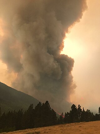
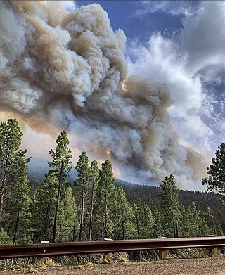
The Rice Ridge Fire was a wildfire that burned northeast of Seeley Lake in the Lolo National Forest in Montana in the United States. The fire, which was started by a lightning strike on July 24, 2017, became a megafire on September 3, growing from 40,000 acres (162 km2) to over 100,000 acres (405 km2), at which time it became the nation’s top wildfire priority as of early September 2017. Located north and east of Seeley Lake, Montana, over 700 firefighting personnel were assigned to the blaze, primarily active in a mountainous lodgepole and mixed conifer forest. The fire had burned 155,900 acres (631 km2) and at one point threatened over 1,000 homes in Powell County and Missoula County including the town of Seeley Lake, Montana and areas north of Highway 200, east of Highway 83. Evacuation orders included parts of Powell County north of Montana Highway 200, areas east of Montana Highway 83, and evacuation warnings for other sections of the forest within Missoula County.
The Alice Creek Fire was a wildfire north of Lincoln in the Lewis and Clark National Forest, located in Lewis and Clark County in Montana in the United States. The fire, started by a lightning strike, was reported on July 22, 2017. The fire burned at least 29,252 acres (118 km2). The Alice Creek Fire crossed the Continental Divide, impacting wildlife, specifically aquatic life, and threatened the Alice Creek Historic District.
The 2017 Montana wildfires were a series of wildfires that burned over the course of 2017.
The Park Creek Fire was a wildfire located two miles north of Lincoln in Helena National Forest and Lewis and Clark National Forest in Montana in the United States. The fire, which was reported on July 14, 2017, was started by lightning and burned over 18,000 acres (73 km2). It threatened the community of Lincoln and directly impacted recreational activities in the national forests.
The Gibralter Fire was a wildfire in Kootenai National Forest, 7 miles (11 km) east of Eureka, Montana in the United States. The fire, which was started by a lightning strike, was reported on August 7, 2017, and burned a total of 12,938 acres (52 km2). The fire threatened numerous private property and structures, as well as recreational and historical sites in the forest.
The Uno Peak Fire was a wildfire on the slopes of Lake Chelan, approximately 15 miles from Manson, Washington in the United States. The human caused fire was started on August 30, 2017. The fire burned a total of 8,726 acres (35 km2).

The Trail Mountain Fire was a wildfire burning in Manti-La Sal National Forest fifteen miles northwest of Orangeville, Utah in the United States. The fire was started on June 6, 2018, after the Trail Mountain prescribed burn escaped due to high winds.

The Ferguson Fire was a major wildfire in the Sierra National Forest, Stanislaus National Forest and Yosemite National Park in California in the United States. The fire was reported on July 13, 2018, burning 96,901 acres (392 km2), before it was 100% contained on August 19, 2018. Interior areas of the fire continued to smolder and burn until September 19, 2018, when InciWeb declared the fire to be inactive. The Ferguson Fire was caused by the superheated fragments of a faulty vehicle catalytic converter igniting vegetation. The fire, which burned mostly in inaccessible wildland areas of the national forest, impacted recreational activities in the area, including in Yosemite National Park, where Yosemite Valley and Wawona were closed. The Ferguson Fire caused at least $171.2 million in damages, with a suppression cost of $118.5 million and economic losses measuring $52.7 million. Two firefighters were killed and nineteen others were injured in the fire.
The Mendocino Complex Fire was a large complex of wildfires that burned in northern California for more than three months in 2018. It consisted of two wildfires, the River Fire and Ranch Fire, which burned in Mendocino, Lake, Colusa, and Glenn Counties in California, with the Ranch Fire being California's single-largest recorded wildfire at the time until the August Complex fire in 2020. The Ranch Fire burned eight miles northeast of Ukiah, and the River Fire burned six miles north of Hopland, to the south of the larger Ranch Fire. First reported on July 27, 2018, both fires burned a combined total of 459,123 acres (1,858 km2), before they were collectively 100% contained on September 18, though hotspots persisted until the complex was fully brought under control on January 4, 2019. The Ranch Fire alone burned 410,203 acres (1,660 km2), making it the largest wildfire in modern California history at the time until the August Complex fire that occurred in 2020. The Ranch Fire also surpassed the size of the 315,577-acre Rush Fire, which burned across California and Nevada, as well as the Santiago Canyon Fire of 1889, which was previously believed to have been California's all-time largest wildfire.

2020 was a record-setting year for wildfires in California. Over the course of the year, 8,648 fires burned 4,304,379 acres (1,741,920 ha), more than four percent of the state's roughly 100 million acres of land, making 2020 the largest wildfire season recorded in California's modern history. However, it is roughly equivalent to the pre-1800 levels which averaged around 4.4 million acres yearly and up to 12 million in peak years. California's August Complex fire has been described as the first "gigafire", burning over 1 million acres across seven counties, an area larger than the state of Rhode Island. The fires destroyed over 10,000 structures and cost over $12.079 billion in damages, including over $10 billion in property damage and $2.079 billion in fire suppression costs. The intensity of the fire season has been attributed to a combination of more than a century of poor forest management and higher temperatures resulting from climate change.

The 2020 Loyalton Fire was a large wildfire in Lassen, Plumas and Sierra counties in California and Washoe County in Nevada. After it was ignited by lightning on August 14, 2020, the fire burned 47,029 acres (19,032 ha) in the Tahoe National Forest and the Humboldt-Toiyabe National Forest before it was fully contained on August 26. The Loyalton Fire was notable for generating three fire tornadoes on August 15, necessitating first-of-their-kind warnings by the National Weather Service.

The North Complex Fire was a massive wildfire complex that burned in the Plumas National Forest in Northern California in the counties of Plumas and Butte. Twenty-one fires were started by lightning on August 17, 2020; by September 5, all the individual fires had been put out with the exception of the Claremont and Bear Fires, which merged on that date, and the Sheep Fire, which was then designated a separate incident. On September 8, strong winds caused the Bear/Claremont Fire to explode in size, rapidly spreading to the southwest. On September 8, 2020, the towns of Berry Creek and Feather Falls were immediately evacuated at 3:15 p.m. PDT with no prior warning. By September 9, 2020, the towns of Berry Creek and Feather Falls had been leveled, with few homes left standing. The fire threatened the city of Oroville, before its westward spread was stopped. The fire killed 16 people and injured more than 100. The complex burned an estimated 318,935 acres (129,068 ha), and was 100% contained on December 3. The fire was managed by the U.S. Forest Service in conjunction with Cal Fire, with the primary incident base in Quincy. The North Complex Fire is the eighth-largest in California's history, and was the deadliest fire in the 2020 California wildfire season.

The Western United States experienced a series of major wildfires in 2020. Severe August thunderstorms ignited numerous wildfires across California, Oregon, and Washington, followed in early September by additional ignitions across the West Coast. Fanned by strong, gusty winds and fueled by hot, dry terrains, many of the fires exploded and coalesced into record-breaking megafires, burning more than 10.2 million acres of land, mobilizing tens of thousands of firefighters, razing over ten thousand buildings, and killing at least 37 people. The fires caused over $19.884 billion in damages, including $16.5 billion in property damage and $3.384 billion in fire suppression costs. Climate change and poor forest management practices contributed to the severity of the wildfires.

The Cameron Peak fire was a wildfire that started near Chambers Lake, Colorado, 25 miles (40 km) east of Walden and 15 miles (24 km) southwest of Red Feather Lakes near Cameron Pass on August 13, 2020, and was declared 100% contained on December 2, 2020. The fire burnt 208,663 acres through the Arapaho and Roosevelt National Forests in Larimer and Jackson Counties and Rocky Mountain National Park. At its peak, the fire forced the evacuation of over 6,000 residents in Estes Park, Chambers Lake, Rustic, Glacier View Meadows, Red Feather Lakes, Masonville, Glen Haven, Spring Canyon, various small communities along Highway 14, Stove Prairie Landing Road, as well as the Colorado State University Mountain Campus and had over 1,000 personnel fighting the fire. 469 structures were destroyed by the fire, including 220 outbuildings and 42 primary residences. The fire became the largest wildfire in Colorado history, surpassing the Pine Gulch Fire, which had set the same mark just seven weeks prior.
The 2020 Lassen County wildfire season included seven large wildfires that burned entirely or in part in Lassen County. A total of 203,296 acres (82,271 ha) of land was burned in Lassen County, making it one of the larger clusters of fires in the 2020 California wildfire season.

Wildfires across the US state of Arizona burned 524,428 acres (212,228 ha) of land in at least 1,773 fires, fueled in part by a drought, hot temperatures, and thunderstorms producing dry lightning. At one point in late June, over 20 active wildfires were burning across the state.

The 2020 Maricopa County wildfires were a series of major and non-major wildfires that took place in Maricopa County, Arizona, from the month of May to the month of October. In the year 2020, Arizona saw one of its worst fire seasons in the states history. Due to the lack of precipitation needed in Arizona, the state fell into an ongoing drought from late 2020 and 2021. High winds were also present during the summer when fire season is mostly active in the state. These factors led to the wildfires in Maricopa County to be destructive and costly.

The 2022 Calf Canyon/Hermits Peak Fire was the largest and most destructive wildfire in the history of New Mexico. The fire burned 341,471 acres between early April and late June in the southern Sangre de Cristo Mountains, in San Miguel, Mora, and Taos counties. It was the most significant fire of the record-breaking 2022 New Mexico wildfire season, as well as the largest wildfire of the year in the contiguous United States. The fire destroyed at least 903 structures, including several hundred homes, and damaged 85 more.
The Cerro Pelado Fire was a wildfire that burned in the southern Jemez Mountains in Sandoval County, southwest of Los Alamos, in the state of New Mexico in the United States as part of the 2022 New Mexico wildfire season. The cause of the fire was determined to be an escaped prescribed burn started by the US Forest Service. The wildfire started on April 22, 2022, during extreme fire weather conditions. As of 15 June 2022, the Cerro Pelado Fire has burned 45,605 acres (18,456 ha) and is 100% contained.


