
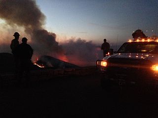
The 2009 California wildfires were a series of 9,159 wildfires that were active in the US state of California, during the year 2009. The fires burned more than 422,147 acres of land from early February through late November, due to Red Flag conditions, destroying hundreds of structures, injuring 134 people, and killing four. The wildfires also caused at least US$134.48 million in damage. Although the fires burned many different regions of California in August, the month was especially notable for several very large fires which burned in Southern California, despite being outside of the normal fire season for that region.

The Tumblebug Complex Fire burned 14,570 acres (5,900 ha) of Willamette National Forest land in Lane County, Oregon, United States, from September 12, 2009 to October 2009. The fire was located about 23 miles (37 km) southeast of Oakridge, Oregon, and roughly 5 miles (8.0 km) southwest of Crescent Lake.

Kelly's Camp is a small district of vacation cabins on the west shore of Lake McDonald in Glacier National Park, Montana, USA. Kelly's Camp consists of twelve log buildings along the western shore of the lake. The structures were notable for being one of the most extensive summer cabin enclaves remaining in the park. Early reports following the advance of the Howe Ridge Fire on August 12, 2018 are that nine or ten structures have been destroyed.

The Rough Fire was a devastating fire of the 2015 California wildfire season. The fire burned 151,623 acres (61,360 ha) of land, making it the largest fire of the year in California, involving up to 3,742 firefighters in the fire suppression efforts.

The Barry Point Fire was a wildfire that burned over 92,977 acres (376.26 km2) of Oregon and California forest land during the summer of 2012. The fire began on 5 August 2012, the result of a lightning strike. The fire consumed public forest and rangeland as well as private forest and grazing land located in Lake County, Oregon and Modoc County, California. The public lands effected by the fire are administered by the United States Forest Service and the Oregon Department of Forestry. The largest part of the private land was owned by the Collins Timber Company. At the peak of the firefighting effort, there were 1,423 personnel working on the fire. It took 22 days to fully contain the fire and then an additional three weeks to mop it up.
On Friday, April 16, 2016, a 200-acre (81 ha) forest fire was first reported in Shenandoah National Park in the U.S. state of Virginia. The fire originated in the area around Rocky Mount, a mountain in the south district of the park, in a remote region south of Elkton, Virginia. The fire was west of Skyline Drive, the scenic byway that runs through the park. By April 17, the fire had spread to over 500 acres (200 ha), prompting closures of Skyline Drive from mile markers 65 at Swift Run Gap to 79 at Loft Mountain. Additionally, more than a dozen hiking trails were closed, including a section of the Appalachian Trail. By Monday April 18, officials reported that the fire had spread to over 2,000 acres (810 ha) and that a Type 1 incident management team and several hotshot firefighting crews had been dispatched to address the situation. By Wednesday April 20, more than 200 firefighters were on scene or en route, supported by two helicopters carrying water buckets and eight fire engines. National Park Service officials reported on the morning of April 20 that the fire had spread to 4,000 acres (1,600 ha) and that 250 firefighting personnel were engaged in establishing firelines in an effort to control the blaze. By that evening, officials had reported that the fire had expanded to roughly 5,616 acres (2,273 ha) and that at mile marker 76 on Skyline Drive, the fire had crossed the road and burned another 80 to 100 acres. The fire was only 1 percent contained and full containment was not anticipated until April 30 because of ongoing weather conditions favoring fire growth. By the evening of Thursday, April 21, the fire had expanded to 7,935 acres (3,211 ha) and more than 300 firefighting and support personnel had been assigned to the fire. The fire expanded to 8,952 acres (3,623 ha) and 342 firefighters were assigned to the fire by the evening of April 22.
The Sherpa Fire was a wildfire that burned in the Santa Ynez Mountains along the Gaviota Coast in the southwestern part of Santa Barbara County, California in June 2016. In a matter of hours the fire spread to over 1,400 acres (570 ha) as the fire was propelled by downslope sundowner winds. This offshore northerly wind contrasts with the more typical onshore flow and sent the fire down the canyons towards the ocean with gusts of over 35 miles per hour (56 km/h). The wildfire resulted in evacuations at two state beach campgrounds and some residences together with intermittent interruption of traffic on a state transportation route.

The 2016 Southeastern United States Wildfires were a series of wildfires in the Southeastern United States in October and November 2016. As of November 15, 2016, the U.S. Forest Service reported tracking 33 wildfires that had burned about 90,000 acres (36,000 ha).

The Sprague Fire was a wildfire in Glacier National Park in the U.S. state of Montana. It was first reported on August 10, 2017 around 8:30pm after it was caused by a lightning storm. The fire encompassed 16,982 acres (6,872 ha). It nearly destroyed the historic Sperry Chalet.

The 2017 Montana wildfires were a series of wildfires that burned over the course of 2017.

The Adair Peak Fire was a wildfire in Glacier National Park in the U.S. state of Montana and was first reported on August 12, 2017 around 10:17 AM after it was caused by a lightning storm over the region that occurred several days before it was first spotted. The Adair Peak Fire encompassed 4,074 acres (1,649 ha). The fire forced the closure of the North Fork Road from the Polebridge Ranger Station south to Camas Creek as well as the Logging Creek and Quartz Creek campgrounds. Structure protection was performed at the Lower Logging Lake Snowshoe Cabin and Boathouse by a small firefighting crew that wrapped the structures with a fire resistant sheeting. The fire was started by the same dry lightning storm that ignited the Sprague Fire near Lake McDonald that destroyed the Sperry Chalet on August 31.

The Pawnee Fire was a large wildfire that burned in Spring Valley in Lake County, California, in the United States. The fire started on June 23, 2018, and quickly expanded overnight, destroying 12 structures, and causing the evacuation of the entire Spring Valley area. The fire destroyed 22 structures, damaged six structures, and burned a total of 15,185 acres (61 km2) before it was fully contained on July 8, 2018.

The Ferguson Fire was a wildfire in the Sierra National Forest, Stanislaus National Forest and Yosemite National Park in California in the United States. The fire was reported on July 13, 2018, burning 96,901 acres (392 km2), before it was 100% contained on August 19, 2018. Interior areas of the fire continued to smolder and burn until September 19, 2018, when InciWeb declared the fire to be inactive. The Ferguson Fire was caused by the superheated fragments of a faulty vehicle catalytic converter igniting vegetation. The fire, which burned mostly in inaccessible wildland areas of the national forest, has impacted recreational activities in the area, including in Yosemite National Park, where Yosemite Valley and Wawona were closed. The Ferguson fire caused at least $171.2 million in damages, with a suppression cost of $118.5 million and economic losses measuring $52.7 million. Two firefighters were killed and nineteen others were injured in the fire.

The Carr Fire was a large wildfire that burned in Shasta and Trinity Counties in California, United States. The fire burned 229,651 acres, before it was 100% contained late on August 30, 2018. The Carr Fire destroyed at least 1,604 structures while damaging 277 others, becoming the sixth-most destructive fire in California history, as well as the seventh-largest wildfire recorded in modern California history. The Carr Fire cost over $1.659 billion (2018) in damages, including $1.5 billion in insured losses and more than $158.7 million in suppression costs. At its height, the fire engaged as many as 4,766 personnel from multiple agencies. The fire was reported on the afternoon of July 23, 2018, at the intersection of Highway 299 and Carr Powerhouse Road, in the Whiskeytown district of the Whiskeytown–Shasta–Trinity National Recreation Area. Coincidental to the name of the incident, the fire was started when a flat tire on a vehicle caused the wheel's rim to scrape against the asphalt, creating sparks that set off the fire.
The Mendocino Complex Fire was the largest recorded fire complex in California history. It was a large complex of two wildfires, the River Fire and Ranch Fire, which burned in Mendocino, Lake, Colusa, and Glenn Counties in the U.S. State of California, with the Ranch Fire being California's single-largest recorded wildfire. The Ranch Fire burned eight miles northeast of Ukiah, and the River Fire burned six miles north of Hopland, to the south of the larger Ranch Fire. First reported on July 27, 2018, both fires burned a combined total of 459,123 acres (1,858 km2), before they were collectively 100% contained on September 18; the Ranch Fire alone burned 410,203 acres (1,660 km2), surpassing the Thomas Fire to become the single-largest modern California wildfire. The Ranch Fire also surpassed the size of the 315,577-acre Rush Fire, which burned across California and Nevada, as well as the Santiago Canyon Fire of 1889, which was previously believed to have been California's all-time largest wildfire. The fires collectively destroyed 280 structures while damaging 37 others; causing at least $267 million in damages, including $56 million in insured property damage and $201 million in fire suppression costs. The city of Lakeport, communities of Kelseyville, Lucerne, Upper Lake, Nice, Saratoga Springs, Witter Springs, Potter Valley, and Finley, parts of Hopland, and the tribal communities of Hopland Rancheria, Big Valley Rancheria, and Habematolel Pomo of Upper Lake were evacuated.

The Holy Fire was a wildfire that burned in the Cleveland National Forest in Orange and Riverside Counties, California. The wildfire started on August 6, 2018 at around 1:15 PM PDT, in the vicinity of Trabuco Canyon. The suspected arsonist, Forrest Gordon Clark, has been booked into the Orange County jail in Santa Ana, California. The blaze burned 23,136 acres (94 km2) and destroyed 18 buildings, before it was fully contained on September 13, 2018. While the fire was actively spreading in early and mid-August, residents of the nearby cities of Corona, Temescal Valley, and Lake Elsinore were placed under evacuation orders.

The Boundary Fire is a wildfire in Glacier National Park in the U.S. state of Montana. First reported in the evening of August 23, 2018, the fire is located slightly more than a mile west of Waterton Lake in the Boundary Creek Valley near Campbell Mountain. The fire straddles the international border but did not cross into Waterton Lakes National Park in Alberta, Canada. After it was detected on August 23, the fire quickly grew to more than 1,500 acres (610 ha) over the next two days but cooler and wetter weather conditions prevented significant growth after that. Firefighters were deployed to the Goat Haunt region to install sprinklers and be prepared for structure protection. By September 9 the fire was reported as being 2,896 acres (1,172 ha) and only 12 percent contained.
The Roosevelt Fire is a wildfire in Bridger-Teton National Forest in the U.S. state of Wyoming. The ignition point was near the head of the Hoback River in the Wyoming Range 32 miles (51 km) south of the town of Jackson, Wyoming. The fire was reported by a hunting party on September 15, 2018; the party attempted to leave the area on September 16, but ideal fire conditions allowed for rapid growth and two of them were forced to jump into a creek to escape the flames. The hunters, a father and son, were transported to a local hospital then to a burn center in Salt Lake City. By Monday September 17, the fire had moved several miles east, triggering evacuations in residential areas northwest of Pinedale, Wyoming in its path. By September 18, the fire was moving northeast, prompting the evacuation of the Hoback Ranches subdivision south of the town of Bondurant for a total of 230 homes evacuated. By the morning of September 19, the fire had expanded to over 25,000 acres (10,000 ha).. As of September 20, the fire began to burn outside the national forest to the edge of the Hoback Ranches; and was 3 mi (4.8 km) west of U.S. Route 189/191, leading officials to declare that further encroachment toward the highway would lead them to shut down a section of it for public safety. By September 21, more than a half dozen helicopters were assigned to and several air tankers were dropping retardant on the fire which was reported to have grown to 34,411 acres (13,926 ha). On September 23 the fire was spreading rapidly to the east and north forcing authorities to close a fifty mile stretch of U.S. route 189/191 from mile marker 110 to 160 to clear the road for evacuations underway, however the highway was reopened the following day.

The Swan Lake Fire is a large lightning-caused wildfire that has been burning between Sterling and Cooper Landing on the Kenai Peninsula in Alaska since June 5, 2019. As of September 9, the fire has burned 167,164 acres (67,649 ha) and is 90 percent contained.
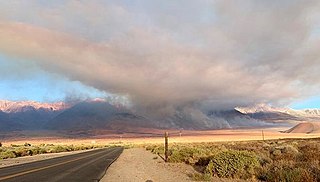
The Taboose Fire was a wildfire burning in Inyo National Forest, southwest of Big Pine and northwest of Aberdeen in Inyo County in the state of California, in the United States. The fire started September 4, 2019 and on October 7, it had burned 10,296 acres (4,167 ha) and was 75 percent contained. The cause of the fire was lightning. Select trails, campgrounds and roads in Inyo National Forest, Sequoia National Park and Kings Canyon National Park had been closed due to the fire. The community of Baxter Ranch was under mandatory evacuation.

