Seeley Lake, Montana

Last updated

Seeley Lake, Montana
CDP
Seeley Lake Montana 20130716 04.JPG
Missoula County Montana Incorporated and Unincorporated areas Seeley Lake Highlighted.svg
Location of Seeley Lake, Montana
Coordinates: 47°10′1″N113°28′1″W / 47.16694°N 113.46694°W / 47.16694; -113.46694
Country United States
State Montana
County Missoula
Area
[1]
  Total13.13 sq mi (34.00 km2)
  Land12.26 sq mi (31.75 km2)
  Water0.87 sq mi (2.25 km2)
Elevation
4,019 ft (1,225 m)
Population
 (2020)
  Total1,682
  Density137.21/sq mi (52.97/km2)
Time zone UTC-7 (Mountain (MST))
  Summer (DST) UTC-6 (MDT)
ZIP code
59868
Area code 406
FIPS code 30-67150
GNIS feature ID0799011
Seeley Lake Historical Society Seeley Lake Historical Society 20130716 01.JPG
Seeley Lake Historical Society

Seeley Lake is a census-designated place (CDP) in Missoula County, Montana, United States. It is part of the 'Missoula, Montana Metropolitan Statistical Area'. The town sits beside the 1,031.5 acres lake Seeley Lake. [2] The population was 1,682 at the 2020 census.

Contents

The community of Seeley Lake is named for Jasper B. Seely who built a cabin on what was in 1881 known as Clearwater Lake. [3] Seely served as the first ranger on the Lewis and Clarke Forest Reserve. The first road to Seeley Lake came in 1895.

Geography

According to the United States Census Bureau, the CDP has a total area of 11.0 square miles (28 km2), of which 10.9 square miles (28 km2) is land and 0.2 square miles (0.52 km2) (1.36%) is water.

Climate

According to the Köppen Climate Classification system, Seeley Lake has a warm-summer humid continental climate, abbreviated "Dfb" on climate maps. The hottest temperature recorded in Seeley Lake was 102 °F (38.9 °C) on July 7, 2007, while the coldest temperature recorded was −53 °F (−47.2 °C) on January 7, 1937. [4]

Climate data for Seeley Lake, Montana, 1991–2020 normals, extremes 1936–present
MonthJanFebMarAprMayJunJulAugSepOctNovDecYear
Record high °F (°C)55
(13)
62
(17)
73
(23)
86
(30)
93
(34)
98
(37)
102
(39)
101
(38)
96
(36)
86
(30)
66
(19)
61
(16)
102
(39)
Mean maximum °F (°C)44.5
(6.9)
49.8
(9.9)
59.3
(15.2)
69.4
(20.8)
80.4
(26.9)
87.1
(30.6)
93.6
(34.2)
93.4
(34.1)
88.3
(31.3)
75.3
(24.1)
54.5
(12.5)
43.1
(6.2)
95.2
(35.1)
Mean daily maximum °F (°C)32.0
(0.0)
36.5
(2.5)
45.1
(7.3)
53.6
(12.0)
64.5
(18.1)
72.2
(22.3)
83.2
(28.4)
82.9
(28.3)
72.8
(22.7)
56.0
(13.3)
39.6
(4.2)
30.6
(−0.8)
55.8
(13.2)
Daily mean °F (°C)22.0
(−5.6)
24.7
(−4.1)
32.5
(0.3)
40.2
(4.6)
49.4
(9.7)
56.4
(13.6)
63.7
(17.6)
62.8
(17.1)
54.6
(12.6)
42.4
(5.8)
30.5
(−0.8)
21.8
(−5.7)
41.8
(5.4)
Mean daily minimum °F (°C)12.1
(−11.1)
12.8
(−10.7)
19.9
(−6.7)
26.8
(−2.9)
34.2
(1.2)
40.5
(4.7)
44.3
(6.8)
42.6
(5.9)
36.5
(2.5)
28.7
(−1.8)
21.3
(−5.9)
13.0
(−10.6)
27.7
(−2.4)
Mean minimum °F (°C)−18.2
(−27.9)
−14.9
(−26.1)
−0.5
(−18.1)
15.3
(−9.3)
23.1
(−4.9)
30.3
(−0.9)
35.3
(1.8)
33.3
(0.7)
26.1
(−3.3)
13.3
(−10.4)
1.6
(−16.9)
−10.4
(−23.6)
−27.1
(−32.8)
Record low °F (°C)−53
(−47)
−45
(−43)
−42
(−41)
−4
(−20)
13
(−11)
23
(−5)
28
(−2)
24
(−4)
15
(−9)
−10
(−23)
−31
(−35)
−44
(−42)
−53
(−47)
Average precipitation inches (mm)2.63
(67)
1.92
(49)
1.44
(37)
1.37
(35)
1.88
(48)
2.31
(59)
1.07
(27)
0.96
(24)
1.19
(30)
1.96
(50)
2.52
(64)
2.35
(60)
21.60
(549)
Average snowfall inches (cm)30.4
(77)
18.5
(47)
15.2
(39)
4.5
(11)
0.7
(1.8)
0.4
(1.0)
0.0
(0.0)
0.0
(0.0)
0.0
(0.0)
2.3
(5.8)
18.0
(46)
28.9
(73)
118.9
(301.6)
Average extreme snow depth inches (cm)24.0
(61)
26.0
(66)
23.3
(59)
7.9
(20)
0.0
(0.0)
0.0
(0.0)
0.0
(0.0)
0.0
(0.0)
0.0
(0.0)
1.3
(3.3)
7.1
(18)
15.7
(40)
29.1
(74)
Average precipitation days (≥ 0.01 in)15.811.311.911.511.713.77.07.38.911.613.615.6139.9
Average snowy days (≥ 0.1 in)13.89.67.93.50.50.10.00.00.01.38.514.059.2
Source 1: NOAA [5]
Source 2: National Weather Service [4]

Aftermath of Rice Ridge Fire

In late summer 2017, Seeley Lake suffered an extended period of hazardous air quality as a result of the Rice Ridge Fire, prompting local officials to urge all residents to evacuate their homes. [6] Scooper aircraft were used to fetch water from Seeley Lake to fight the fire. [7] A followup study will measure the health impacts of the smoke. [8]

Demographics

Historical population
CensusPop.Note
2020 1,682
U.S. Decennial Census [9]

As of the census [10] of 2010, there were 1,659 people, 589 households, and 411 families residing in the CDP. The population density was 131.9 inhabitants per square mile (50.9/km2). There were 938 housing units at an average density of 86.2 per square mile (33.3/km2). The racial makeup of the CDP was 96.94% White, 0.07% African American, 1.46% Native American, 0.21% Asian, 0.49% from other races, and 0.84% from two or more races. Hispanic or Latino of any race were 1.46% of the population.

There were 589 households, out of which 29.2% had children under the age of 18 living with them, 59.4% were married couples living together, 5.1% had a female householder with no husband present, and 30.1% were non-families. 24.3% of all households were made up of individuals, and 6.3% had someone living alone who was 65 years of age or older. The average household size was 2.44 and the average family size was 2.89.

In the CDP, the population was spread out, with 25.3% under the age of 18, 5.2% from 18 to 24, 28.3% from 25 to 44, 29.5% from 45 to 64, and 11.8% who were 65 years of age or older. The median age was 41 years. For every 100 females, there were 113.4 males. For every 100 females age 18 and over, there were 112.1 males.

The median income for a household in the CDP was $35,101, and the median income for a family was $38,188. Males had a median income of $30,000 versus $18,269 for females. The per capita income for the CDP was $18,825. About 7.0% of families and 10.6% of the population were below the poverty line, including 14.4% of those under age 18 and 4.8% of those age 65 or over.

Education

It is in the Seeley Lake Elementary School District and the Missoula High School District. [11]

Seeley-Swan High School provides education for 9th through 12th grade. [12] Their mascot is the Blackhawks. [13]

The Missoula Public Library has a branch location in Seeley Lake. [14]

Media

The Seeley-Swan Pathfinder is the newspaper for Seeley Lake. [15] It is published weekly.

See also

Related Research Articles

<span class="mw-page-title-main">Missoula County, Montana</span> County in Montana, United States

Missoula County is located in the State of Montana. As of the 2020 census, the population was 117,922, making it Montana's third most populous county. Its county seat and most populous city is Missoula. The county was founded in 1860.

<span class="mw-page-title-main">Lake County, Montana</span> County in Montana, United States

Lake County is a county located in the northwest part of the U.S. state of Montana. As of the 2020 census, the population was 31,134. Its county seat is Polson.

<span class="mw-page-title-main">Busby, Montana</span> Census-designated place in Big Horn County, Montana, United States

Busby is a census-designated place (CDP) in Big Horn County, Montana, United States. It is on the Northern Cheyenne reservation. The population was 745 at the 2010 census.

<span class="mw-page-title-main">Bigfork, Montana</span> Unincorporated community in Montana, United States

Bigfork is a census-designated place (CDP) in Flathead County, Montana, United States. It is within Montana's Rocky Mountains. The population was 5,118 at the 2020 census, up from 4,270 in 2010.

<span class="mw-page-title-main">Big Arm, Montana</span> Census-designated place in Montana, United States

Big Arm is a census-designated place (CDP) in Lake County, Montana, United States. The population was 177 at the 2010 census, up from 131 in 2000.

<span class="mw-page-title-main">Ravalli, Montana</span> Place in Montana, United States

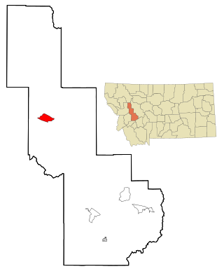
Ravalli is an unincorporated community in Lake County, Montana, United States. The population was 76 at the 2010 census, down from 119 in 2000. For statistical purposes, the United States Census Bureau has defined Ravalli as a census-designated place (CDP). In the early 1900s, the Pablo-Allard herd in Ravalli was said to be the largest collection of the bison remaining in the U.S. and played a critical role in the conservation of bison.

<span class="mw-page-title-main">Augusta, Montana</span> Census-designated place in Montana, United States

Augusta is an unincorporated community and census-designated place (CDP) in Lewis and Clark County, Montana, United States. The population was 309 at the 2010 census and rose to 316 in the 2020 census. The most accepted version in the naming of this town is after Augusta Hogan, thought to be the first child born in this town, the daughter of J. D. Hogan, an early rancher.

<span class="mw-page-title-main">Lincoln, Montana</span> Census-designated place in Montana, United States

Lincoln is an unincorporated community and census-designated place (CDP) in Lewis and Clark County, Montana, United States. As of the 2010 census, the population was 1,013.

<span class="mw-page-title-main">Bonner-West Riverside, Montana</span> CDP in Montana, United States

Bonner-West Riverside is a census-designated place (CDP) in Missoula County, Montana, United States, including the unincorporated communities of Bonner, Milltown, West Riverside, and Pinegrove. It is part of the Missoula, Montana Metropolitan Statistical Area. The population was 1,663 at the 2010 census, a decline from its population of 1,693 in 2000.

<span class="mw-page-title-main">Clinton, Montana</span> CDP in Montana, United States

Clinton is a census-designated place (CDP) in Missoula County, Montana, United States. It is part of the 'Missoula, Montana Metropolitan Statistical Area'. The CDP was named for General Sir Henry Clinton. The population was 1,052 at the 2010 census, an increase from its population of 549 in 2000.

<span class="mw-page-title-main">East Missoula, Montana</span> CDP in Montana, United States

East Missoula is a census-designated place (CDP) in Missoula County, Montana, United States. It is part of the Missoula, Montana Metropolitan Statistical Area'. The population was 2,157 at the 2010 census, an increase from its population of 2,070 in 2000.

<span class="mw-page-title-main">Evaro, Montana</span> CDP in Montana, United States

Evaro is a census-designated place (CDP) in Missoula County, Montana, United States, and part of the Missoula Metropolitan Statistical Area. It is located on the southernmost tip of the Flathead Indian Reservation, approximately 12 miles (19 km) north of downtown Missoula and is served by US Highway 93. In 2010, Evaro had a population of 322, a decrease from 329 in 2000.

<span class="mw-page-title-main">Frenchtown, Montana</span> CDP in Montana, United States

Frenchtown is a census-designated place (CDP) in Missoula County, Montana, United States. It is part of the Missoula, Montana Metropolitan Statistical Area. The population was 1,825 at the 2010 census, an increase from its population of 883 in 2000.

<span class="mw-page-title-main">Lolo, Montana</span> CDP in Montana, United States

Lolo is a census-designated place (CDP) in Missoula County, Montana, United States. It is part of the Missoula Metropolitan Statistical Area. The population was 4,399 at the 2020 census, an increase from its population of 3,892 in 2010. It is home to Travelers' Rest State Park, a site where Lewis and Clark camped in 1805 and again in 1806.

<span class="mw-page-title-main">Orchard Homes, Montana</span> CDP in Montana, United States

Orchard Homes is a census-designated place (CDP) in Missoula County, Montana, United States. It is part of the Missoula Metropolitan Statistical Area. The population was 5,377 at the 2020 census.

<span class="mw-page-title-main">Wye, Montana</span> Place in Montana, United States

Wye is an unincorporated community in Missoula County, Montana, United States. It is part of the Missoula, Montana Metropolitan Statistical Area. The population was 511 at the 2010 census, an increase from its population of 381 in 2000. For statistical purposes, the United States Census Bureau has defined Wye as a census-designated place (CDP). Wye is named for the "y"-shaped DeSmet Junction where US 93 and MT 200 met former US 10.

<span class="mw-page-title-main">Ovando, Montana</span> CDP in Montana, United States

Ovando is a census-designated place (CDP) in Powell County, Montana, United States. It is approximately fifty-four miles ENE of Missoula, Montana. The population was 71 at the 2000 census.

<span class="mw-page-title-main">Arlee, Montana</span> Census-designated place in Montana, United States

Arlee is an unincorporated community and census-designated place (CDP) on the Flathead Reservation, Lake County, Montana, United States. The population was 725 at the 2020 census. It is named after Alee, a Salish chief. The chief's name has no "r", as the Salish alphabet has no letter "r".

Box Elder is an unincorporated community and census-designated place (CDP) in Hill County in the U.S. state of Montana. The population was 87 at the 2010 census. The population was 794 at the 2000 census, but before 2010 the Box Elder CDP was split into the current much-smaller Box Elder CDP, while most of the former CDP area went into the new Rocky Boy West CDP. Box Elder is the headquarters of the Chippewa-Cree tribe.

<span class="mw-page-title-main">Power, Montana</span> CDP in Montana, United States

Power is a census-designated place (CDP) in Teton County, Montana, United States. The population was 171 at the 2000 census. The town is named after Montana pioneer, Thomas Charles Power, who platted the townsite in 1910.

References

  1. "ArcGIS REST Services Directory". United States Census Bureau. Retrieved September 5, 2022.
  2. "FISHMT :: Waterbody Details". myfwp.mt.gov. Retrieved October 2, 2018.
  3. "Seeley Lake". Montana Place Names Companion. Montana Historical Society. Retrieved April 9, 2021.
  4. 1 2 "NOAA Online Weather Data – NWS Missoula". National Weather Service. Retrieved February 21, 2023.
  5. "U.S. Climate Normals Quick Access – Station: Seeley Lake RS, MT". National Oceanic and Atmospheric Administration. Retrieved February 21, 2023.
  6. Volz, Matt (August 10, 2017). "Residents of Smoke-Choked Montana Town Advised to Leave". U.S. News & World Report - AP. Archived from the original on September 26, 2017.
  7. Randy Teague (August 4, 2017), Scoop Planes Fire Bombers 2 Seeley Lake, Mont. 8-1-2017, archived from the original on December 11, 2021, retrieved September 25, 2017
  8. Associated Press (September 22, 2017). "Researchers launch study to learn effects of wildfire smoke". Missoulian . Retrieved September 25, 2017.
  9. "Census of Population and Housing". Census.gov. Retrieved June 4, 2016.
  10. "U.S. Census website". United States Census Bureau . Retrieved January 31, 2008.
  11. "2020 CENSUS - SCHOOL DISTRICT REFERENCE MAP: Missoula County, MT" (PDF). U.S. Census Bureau . Retrieved March 13, 2024.
  12. "Seeley-Swan High School". Seeley-Swan High School. Retrieved April 20, 2021.
  13. "Member Schools". Montana High School Association. Retrieved April 19, 2021.
  14. "Hours & Locations". Missoula Public Library. Retrieved April 13, 2021.
  15. "News". Seeley-Swan Pathfinder. Retrieved August 31, 2023.