Huson, Montana

Last updated

Huson, Montana
Huson Mercantile in Huson Montana 2014.jpg
USA Montana location map.svg
Red pog.svg
Huson
Usa edcp location map.svg
Red pog.svg
Huson
Coordinates: 47°01′53″N114°19′38″W / 47.03139°N 114.32722°W / 47.03139; -114.32722
Country United States
State Montana
County Missoula
Area
[1]
  Total0.78 sq mi (2.01 km2)
  Land0.77 sq mi (1.98 km2)
  Water0.01 sq mi (0.03 km2)
Elevation
3,012 ft (918 m)
Population
 (2020) [2]
  Total256
  Density334.64/sq mi (129.21/km2)
Time zone UTC-7 (Mountain (MST))
  Summer (DST) UTC-6 (MDT)
ZIP code
59846 [3]
Area code 406
GNIS feature ID785180 [4]
FIPS code 30-38275

Huson is a census-designated place and unincorporated community in Missoula County, Montana, United States. Its population was 256 as of the 2020 census, [2] up from 210 in 2010. [5]

Contents

History

Huson was established as a railroad station in about 1894. [6] The post office opened as Glaude in about 1897, but was changed to Huson around a year later.

Geography

Huson is in northwestern Missoula County, in the valley of the Clark Fork River, which forms the southern border of the community. It is served by Exit 85 of Interstate 90, which leads southeast 20 miles (32 km) to Missoula and northwest 38 miles (61 km) to Superior.

According to the U.S. Census Bureau, the Huson CDP has an area of 0.78 square miles (2.02 km2), of which 0.01 square miles (0.03 km2), or 1.54%, are water. [1]

Demographics

Historical population
CensusPop.Note
2010 210
2020 25621.9%
U.S. Decennial Census [7]

Education

Frenchtown Public Schools, a unified K-12 school district, covers all of the CDP, [8]

Related Research Articles

<span class="mw-page-title-main">Augusta, Montana</span> Census-designated place in Montana, United States

Augusta is an unincorporated community and census-designated place (CDP) in Lewis and Clark County, Montana, United States. The population was 309 at the 2010 census and rose to 316 in the 2020 census. The most accepted version in the naming of this town is after Augusta Hogan, thought to be the first child born in this town, the daughter of J. D. Hogan, an early rancher.

<span class="mw-page-title-main">Helena Valley Northeast, Montana</span> Census-designated place in Montana, United States

Helena Valley Northeast is a census-designated place (CDP) in Lewis and Clark County, Montana, United States. The population was 2,995 at the 2010 census. It is part of the Helena Micropolitan Statistical Area.

<span class="mw-page-title-main">Alberton, Montana</span> Town in Montana, United States

Alberton is a town in Mineral County, Montana, United States. The population was 452 at the 2020 census. Alberton was the location of a major chlorine chemical release in 1996. It is the home of Northwest Indian Bible School, a Bible-training institution founded and operated by the Allegheny Wesleyan Methodist Connection.

<span class="mw-page-title-main">Riverbend, Montana</span> Census-designated place in Montana, United States

Riverbend is an unincorporated community and census-designated place (CDP) in Mineral County, Montana, United States. The population was 455 at the 2020 census. The community uses the ZIP Code of neighboring Superior, 59872.

<span class="mw-page-title-main">St. Regis, Montana</span> Census-designated place in Montana, United States

St. Regis or Saint Regis is an unincorporated community and census-designated place (CDP) in Mineral County, Montana. The population was 313 at the time of the 2020 census.

<span class="mw-page-title-main">Superior, Montana</span> Town in Montana, United States

Superior is a town in, and the county seat of, Mineral County, Montana, United States. The population was 830 at the 2020 census.

<span class="mw-page-title-main">Bonner-West Riverside, Montana</span> Census-designated place in Montana, United States

Bonner-West Riverside is a census-designated place (CDP) in Missoula County, Montana, United States, including the unincorporated communities of Bonner, Milltown, West Riverside, and Pinegrove. It is part of the Missoula metropolitan area. The population was 1,690 at the 2020 census.

<span class="mw-page-title-main">Clinton, Montana</span> Census-designated place in Montana, United States

Clinton is an unincorporated community and census-designated place (CDP) in Missoula County, Montana, United States. It is part of the Missoula metropolitan area. The population was 1,018 at the 2020 census.

<span class="mw-page-title-main">East Missoula, Montana</span> Census-designated place in Montana, United States

East Missoula is an unincorporated community and census-designated place (CDP) in Missoula County, Montana, United States. It is part of the Missoula metropolitan area. The population was 2,465 at the 2020 census, up from 2,157 in 2010.

<span class="mw-page-title-main">Evaro, Montana</span> Census-designated place in Montana, United States

Evaro is a census-designated place (CDP) in Missoula County, Montana, United States, and part of the Missoula metropolitan area. It is located on the southernmost part of the Flathead Indian Reservation, approximately 20 miles (32 km) north of downtown Missoula via US Highway 93. As of the 2020 census, the population of the CDP was 373, up from 322 in 2010.

<span class="mw-page-title-main">Frenchtown, Montana</span> Census-designated place in Montana, United States

Frenchtown is an unincorporated community and census-designated place (CDP) in Missoula County, Montana, United States. It is part of the Missoula metropolitan area. The population was 1,958 as of the 2020 census.

<span class="mw-page-title-main">Lolo, Montana</span> Census-designated place in Montana, United States

Lolo is an unincorporated community and census-designated place (CDP) in Missoula County, Montana, United States. It is part of the Missoula metropolitan area. The population was 4,399 at the 2020 census, an increase from its population of 3,892 in 2010. It is home to Travelers' Rest State Park, a site where Lewis and Clark camped in 1805 and again in 1806.

<span class="mw-page-title-main">Wye, Montana</span> Place in Montana, United States

Wye is an unincorporated community in Missoula County, Montana, United States. It is part of the Missoula, Montana Metropolitan Statistical Area. The population was 511 at the 2010 census, an increase from its population of 381 in 2000. For statistical purposes, the United States Census Bureau has defined Wye as a census-designated place (CDP). Wye is named for the "y"-shaped DeSmet Junction where US 93 and MT 200 met former US 10.

<span class="mw-page-title-main">Cardwell, Montana</span> Census-designated place in Montana, United States

Cardwell is a census-designated place (CDP) in Jefferson County, Montana, United States. The population was 62 at the 2020 census. It is part of the Helena Micropolitan Statistical Area.

<span class="mw-page-title-main">Arlee, Montana</span> Census-designated place in Montana, United States

Arlee is an unincorporated community and census-designated place (CDP) on the Flathead Reservation, Lake County, Montana, United States. The population was 725 at the 2020 census. It is named after Alee, a Salish chief. The chief's name has no "r", as the Salish alphabet has no letter "r".

Condon is an unincorporated community and census-designated place in Missoula County, Montana, United States. Located along the Swan River and Montana Highway 83, Condon is situated between the Swan Range to the east and the Mission Mountains to the west, providing ready access to the Bob Marshall Wilderness and Mission Mountains Wilderness, respectively. Its population was 285 as of the 2020 United States census, down from 343 in 2010.

<span class="mw-page-title-main">Saltese, Montana</span> Census-designated place in Montana, United States

Saltese is an unincorporated community and census-designated place in Mineral County, Montana, United States. It lies in the valley of the St. Regis River along Interstate 90 at exit 10. As of the 2020 census, the population was 10.

<span class="mw-page-title-main">Craig, Montana</span> Census-designated place in Montana, United States

Craig is an unincorporated community and census-designated place (CDP) in Lewis and Clark County, Montana, United States. As of the 2010 census, the population was 43. Craig is located along Interstate 15 on the west side of the Missouri River, 43 miles (69 km) north of Helena, the state capital, and 47 miles (76 km) southwest of Great Falls.

Swan Lake is a census-designated place and unincorporated community in Lake County, Montana, United States. Its population was 113 as of the 2010 census.

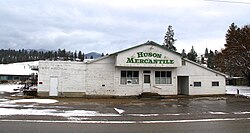
Carlton is a census-designated place (CDP) in Missoula County, Montana, United States. The population was 721 at the 2020 census.

References

  1. 1 2 "2023 U.S. Gazetteer Files: Montana". United States Census Bureau. Retrieved June 4, 2024.
  2. 1 2 "P1. Race – Huson CDP, Montana: 2020 DEC Redistricting Data (PL 94-171)". U.S. Census Bureau. Retrieved June 4, 2024.
  3. United States Postal Service (2012). "USPS - Look Up a ZIP Code" . Retrieved February 15, 2012.
  4. "Huson". Geographic Names Information System . United States Geological Survey, United States Department of the Interior.
  5. "U.S. Census website". United States Census Bureau . Retrieved May 14, 2011.
  6. "Hall". Montana Place Names Companion. Montana Historical Society. Retrieved April 5, 2021.
  7. "Census of Population and Housing". Census.gov. Retrieved June 4, 2016.
  8. "2020 CENSUS - SCHOOL DISTRICT REFERENCE MAP: Missoula County, MT" (PDF). U.S. Census Bureau . Retrieved March 13, 2024.