
Anthony Henday Drive (Highway 216) is a 78-kilometre (48 mi) freeway that encircles Edmonton, Alberta. It is a heavily travelled commuter and truck bypass route with the southwest quadrant serving as a portion of the CANAMEX Corridor that links Canada to the United States and Mexico. Henday is one of the busiest highways in Western Canada, carrying over 108,000 vehicles per day in 2019 at its busiest point near West Edmonton Mall. Rush hour congestion is common on the four-lane section in southwest Edmonton, where traffic levels have risen due to rapid suburban development. Work began in fall 2019 to widen this section to six lanes by the end of 2022.

Alberta Provincial Highway No. 14, commonly referred to as Highway 14, is an east-west highway in central Alberta, Canada. It stretches from Edmonton through Wainwright to the Alberta–Saskatchewan border, running parallel to the more northern Highway 16. Highway 14 is about 257 kilometres (160 mi) long.
Mill Woods is a residential area in the city of Edmonton, Alberta, Canada. Located in southeast Edmonton, Mill Woods is bounded by Whitemud Drive (Highway 14) to the north, 91 Street to the west, 34 Street to the east, and Anthony Henday Drive to the south. Mill Woods is adjacent to three other residential areas including The Meadows to the east across 34 Street, and Southeast Edmonton and Ellerslie to the south and southwest respectively across Anthony Henday Drive.
Transport in Edmonton is fairly typical for a Canadian city of its size, involving air, rail, road and public transit. With very few natural barriers to growth and largely flat to gently rolling terrain bisected by a deep river valley, the city of Edmonton has expanded to cover an area of nearly 768 km2 (297 sq mi), of which only two-thirds is built-up, while the metropolitan area covers around 9,430 km2 (3,640 sq mi). This has resulted in a heavily private transportation-oriented transportation network typical of any other city of its size in North America. However, Edmonton does not have the extensive limited access freeway system typical of what one would find in a US metro area, and the road network is somewhat unusual in regard to access to downtown.
Alberta Provincial Highway No. 627, commonly referred to as Highway 627, is a highway in the province of Alberta, Canada. It runs west to east through rural parts of Parkland County, beginning at Highway 759 about 12 km (7.5 mi) south of Seba Beach and heads due east. It takes name Maskêkosihk Trail passes 215 Street/Winterburn Road, before terminating at 184th Street, and continuing along 184th Street to the Anthony Henday Drive in Edmonton. Portions of 23 Avenue NW and 184 Street NW between Winterburn Road and Anthony Henday Drive were renamed Maskêkosihk Trail in February 2016 to honour Cree heritage.

Whitemud Drive is a major east–west freeway in southern Edmonton, Alberta, that stretches from 231 Street at the western city limit to Anthony Henday Drive just east of Edmonton in Strathcona County. The portion in southeast Edmonton from Anthony Henday Drive to Calgary Trail / Gateway Boulevard is designated as Highway 14, and from there until Anthony Henday Drive in west Edmonton is designated as Highway 2. The portion of Whitemud Drive from 170 Street and 75 Street forms part of the Edmonton inner ring road.
Wayne Gretzky Drive is a freeway in Edmonton, Alberta. Originally Capilano Drive/Capilano Freeway, it was officially renamed October 1, 1999, after NHL hockey player Wayne Gretzky, as a tribute to his years with the Edmonton Oilers. The same day, Wayne Gretzky's number 99 jersey was retired at the Skyreach Centre, which lies just west of Wayne Gretzky Drive, at 118 Avenue. 66/75 Street is a major arterial road in east Edmonton which serves residential and industrial areas.
Terwillegar Drive is a developing freeway in south-west Edmonton, Alberta. It is under construction, with the majority of its intersection at-grade, it retains its arterial road status. Once completed, it will be the third freeway in Edmonton not to have a highway designation after Groat Road and Wayne Gretzky Drive. South of Windermere Boulevard the roadway goes by 170 Street SW.
50 Street is the designated name of two major arterial roads in east Edmonton, Alberta. Separated by the North Saskatchewan River, it is mostly straight, and runs the entire south-north length of Edmonton as well as the suburb of Beaumont. The Yellowhead Trail and 50 Street junction is the start of Highway 15, it then goes north to Manning Drive, which it follows from there. Highway 814 used follow 50 Street between Edmonton and Beaumont, until the Beaumont government took control of the road. The northside section of 50 Street is presently segmented by the developing community of Cy Becker with grading in place for a future interchange at Anthony Henday Drive; however, there is no timeline for construction.

111 Street is a major arterial road in south Edmonton, Alberta, Canada. The south leg of the LRT runs between the northbound and southbound lanes north of 23 Avenue. It passes by Southgate Centre and the former location of Heritage Mall, now the location of the Century Park transit-oriented development.
100 Avenue is a major arterial road in west Edmonton, Alberta, Canada.
97 Street is a major arterial road in north Edmonton, Alberta. It is used to take vehicles in and out of Downtown Edmonton to the city's northern suburban neighbourhoods and to the region's main military installation, CFB Edmonton. North of Yellowhead Trail, it is designated as part of Highway 28.
Mayfield Road, 111 Avenue (Norwood Boulevard), and 112 Avenue is a major arterial road in north Edmonton, Alberta. It serves Edmonton's Northwest Industrial District, the former Town of Jasper Place (amalgamated with Edmonton in 1964), the inner city north Downtown Edmonton, and post-World War II Edmonton. Prior to the opening of Yellowhead Trail in the early 1980s, Highway 16 followed Mayfield Road and 111 Avenue between Stony Plain Road and 109 Street.
Fort Road is a discontinuous street in Edmonton, Alberta, Canada. Historically it was a major route in connecting Edmonton and Fort Saskatchewan. It was formed on the west side of the Canadian National Railway line that formerly connected the two cities, and crossed the North Saskatchewan River just south of the current Highway 15 bridge. As the city of Edmonton expanded its grid street system, and realigned the highway to Manning Drive, portions of Fort Road ceased to exist.
Mill Woods Road, together with 38 Avenue NW, is a ring road in the neighbourhood of Mill Woods, Edmonton, Alberta, Canada. Although Mill Woods is bisected by a number of numbered arterials, Mill Woods has utilized a newer form of residential and street design by building this inner neighbourhood ring, which acts as a collector for the curved and named residential streets.
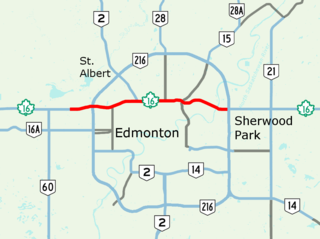
Yellowhead Trail is a 24.6-kilometre (15.3 mi) expressway segment of the Yellowhead Highway in northern Edmonton, Alberta, Canada. It carries a significant amount of truck traffic to and from the industrial areas of north Edmonton and serves as a key commuter route for the bedroom communities of Stony Plain, Spruce Grove, and Sherwood Park, carrying nearly 80,000 vehicles per weekday in 2015. A suburban bypass of the route was completed when the northeast leg of Anthony Henday Drive (Highway 216) opened in late 2016, providing an alternate route through north Edmonton.

16 Avenue N is a major road in Calgary, Alberta, that forms a 26.5-kilometre (16.5 mi) segment of Highway 1 and connects Calgary to Banff and Medicine Hat. It is a four to six-lane principal arterial expressway at its extremities, but is an urban arterial road between the Bow River and Bowness Road, and also between Crowchild Trail and Deerfoot Trail. Due to Calgary's quadrant system, it is known as 16 Avenue NW west of Centre Street and 16 Avenue NE to the east.
Calgary Trail and Gateway Boulevard are a pair of major arterial roadways in Edmonton, Alberta. Gateway Boulevard carries northbound traffic while Calgary Trail carries southbound traffic. From south of 31 Avenue, they form a two-way freeway separated by a median; for this portion, the roadway maintains the separate names for northbound and southbound traffic. Near 31 Avenue, Calgary Trail and Gateway Boulevard separate and become parallel one-way arterial roadways to Saskatchewan Drive, at the edge of the North Saskatchewan River valley. Designated as part of Highway 2 south of Whitemud Drive, it is Edmonton's main southern entrance and is both a major commuter route, connecting to the Edmonton International Airport and Leduc, as well as a regional connection to Red Deer and Calgary.
