
Berkeley Square is a green town square in Mayfair in the West End of London, in the City of Westminster. It was laid out, extending further south, in the mid 18th century by the architect William Kent.

Devonshire House in Piccadilly, Mayfair, was the London townhouse of the Dukes of Devonshire during the 18th and 19th centuries. Following a fire in 1733 it was rebuilt by William Cavendish, 3rd Duke of Devonshire, in the Palladian style, to designs by William Kent. Completed circa 1740, it stood empty after the First World War and was demolished in 1924.

Clarendon House was a town mansion which stood on Piccadilly in London, England, from the 1660s to the 1680s. It was built for the powerful politician Edward Hyde, 1st Earl of Clarendon, and was the grandest private London residence of its era.

Coade stone or Lithodipyra or Lithodipra was stoneware that was often described as an artificial stone in the late 18th and early 19th centuries. It was used for moulding neoclassical statues, architectural decorations and garden ornaments of the highest quality that remain virtually weatherproof today.

Old Devonshire House at 48 Boswell Street, was located between Theobald's Road in Bloomsbury, and Queen Square, London. William Cavendish, 3rd Earl of Devonshire had the house built in 1668 for his son, also called William Cavendish, who was MP for Derby at that time and eventually became the 1st Duke of Devonshire in 1694. This house was later sold by William Cavendish, 3rd Duke of Devonshire, who built Devonshire House in fashionable Piccadilly. Major George Henry Benton Fletcher bought Old Devonshire House in 1932, to display his keyboard collection. He donated the house and his collection to the National Trust in November 1937. The house was destroyed in May 1941 by a Luftwaffe bombing raid on Holborn during the Blitz. Most of his keyboard instruments had been evacuated to Gloucestershire before the raid. These survived and are currently on display in Fenton House, Hampstead.

Asthall Manor is a gabled Jacobean Cotswold manor house in Asthall, Oxfordshire. It was built in about 1620 and altered and enlarged in about 1916. The house is Grade II listed on the National Heritage List for England.
Devonshire Street was a short-lived railway station in the parish of Mile End Old Town, in the East End of London. It was opened on 20 June 1839 as a temporary London terminus of the Eastern Counties Railway (ECR) from Romford prior to the construction of Shoreditch station which became the permanent terminus.
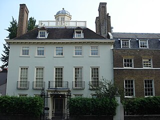
Devonshire House is an 18th-century house at 44 Vicarage Crescent, Battersea, London. It is a listed Grade II* on the National Heritage List for England along with its iron gate and railings. The interior of the house contains its original paneling.

The George and Devonshire is a Grade II listed public house at Burlington Lane, Chiswick, London.

Fulham War Memorial is a Grade II listed monument at Vicarage Garden, Fulham High Street, Fulham, London.

Devonshire Avenue Nature Area is a 0.4 hectare Local Nature Reserve and Site of Borough Importance for Nature Conservation, Grade II, in South Sutton in the London Borough of Sutton. It is owned by Sutton Council and managed by the Council and Sutton Nature Conservation Volunteers.

Stratton Street is a street in the Mayfair district of the City of Westminster, London. It runs from Berkeley Street in the north to Piccadilly in the south.
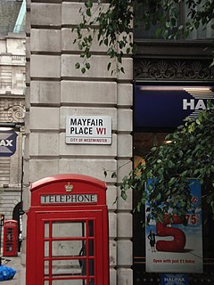
Mayfair Place is a street in the City of Westminster, London. The street joins Stratton Street to Berkeley Street.

The Rose and Crown is a Grade II listed public house at 199 Stoke Newington Church Street, Stoke Newington, Hackney, London, N16 9ES.
Devonshire Place is a street in the City of Westminster, London, that runs from Marylebone Road in the north to Devonshire Street in the south. A number of literary and society figures have lived in the street.

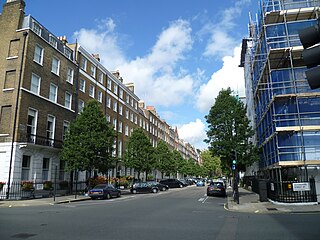
New Cavendish Street is a street in the City of Westminster, London, that runs from Marylebone High Street in the west to Cleveland Street in the east.

The White Horse is a public house on the south side of Castle Street, Hertford. England. The pub occupies numbers 31 and 33 Castle Street, two of a group of three grade II listed houses that also includes number 35. The timber-framed buildings date from the sixteenth and seventeenth centuries with later additions. The pub is under the management of Fullers Brewery.

Chesterfield Street is a "virtually intact" Georgian street in London's Mayfair district. Several of the buildings are Grade II listed on the National Heritage List for England.
Wimpole House at 28–29a Wimpole Street is a group of Grade II listed town houses on the corner of Wimpole Street and New Cavendish Street in the City of Westminster, London.

Hanover Chapel was a church in Regent Street, London. It was built in 1825, and was demolished in 1896.
