This article may be expanded with text translated from the corresponding article in Dutch. Click [show] for important translation instructions.
Machine translation, like DeepL or Google Translate, is a useful starting point for translations, but translators must revise errors as necessary and confirm that the translation is accurate, rather than simply copy-pasting machine-translated text into the English Wikipedia.
Do not translate text that appears unreliable or low-quality. If possible, verify the text with references provided in the foreign-language article.
You must provide copyright attribution in the edit summary accompanying your translation by providing an interlanguage link to the source of your translation. A model attribution edit summary is Content in this edit is translated from the existing Dutch Wikipedia article at [[:nl:A12 (België)]]; see its history for attribution.
You should also add the template {{Translated|nl|A12 (België)}} to the talk page.
The A12 is an incomplete motorway in Belgium. The road starts at the Dutch border near Zandvliet and goes to Antwerp. There the A12 goes onto the Antwerp ring road R1. Then the road goes via Wilrijk in the direction of Brussels (the traffic coming from Ghent takes the A112 via the Jan De Vos Tunnel). From here on, it has frontage roads on both sides. Between Wilrijk and Schelle, the A12 is an expressway with major at-grade intersections that contain also the frontage roads. There, from Schelle, it is again a motorway. Then, in Boom, a tunnel leads the A12 under the Rupel river, where the frontage roads take a bridge and then fuse with the motorway itself. Between Breendonk and Sint-Brixius-Rode, there are again at-grade intersections, and then it is again a motorway, until Brussels, where it ends onto the Brussels Ring.
There are plans to gradually convert the road into a full motorway. Therefore, exits would be built replacing the two intersections in Westrode/Londerzeel and a bridge replacing the intersection near Breendonk. However, in 2010, the intersections are being modernised instead and a frontage road is partially being built in the direction of Brussels.
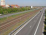
Between Zandvliet and Stabroek (north of Antwerp), the railway runs on the central reservation.
Unusually for a motorway in Belgium, the A12 is not part of the E-road network. However, for much of its length it runs a few kilometers to the west of and parallel with the A1 which forms a part of the European route E19.
Pictures
Picture of the A12 and the railway line 11
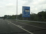
The A12 in the direction of Willebroek
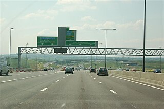
The A12 near Zandvliet, in the direction of Bergen-op-Zoom
Transport in Belgium is facilitated with well-developed road, air, rail and water networks. The rail network has 2,950 km (1,830 mi) of electrified tracks. There are 118,414 km (73,579 mi) of roads, among which there are 1,747 km (1,086 mi) of motorways, 13,892 km (8,632 mi) of main roads and 102,775 km (63,861 mi) of other paved roads. There is also a well-developed urban rail network in Brussels, Antwerp, Ghent and Charleroi. The ports of Antwerp and Bruges-Zeebrugge are two of the biggest seaports in Europe. Brussels Airport is Belgium's biggest airport.
European route E19 is a 551-kilometre (342 mi) long European route. It connects the Netherlands to France via Belgium. Among the places included in its itinerary are:
The A2 is a major road in south-east England, connecting London with the English Channel port of Dover in Kent. This route has always been of importance as a connection between London and sea trade routes to Continental Europe. It was originally known as the Dover Road. The M2 motorway has replaced part of the A2 as the strategic route.
Berchem is a southern district of the municipality and city of Antwerp in the Flemish Region of Belgium. Berchem is located along the old Grote Steenweg that has connected Brussels to Antwerp for several centuries; the town borders the districts of Deurne, Borgerhout, Wilrijk and Antwerp and the municipality of Mortsel. Berchem itself consists of three quarters, Oud Berchem, Groenenhoek and Nieuw Kwartier.
A controlled-access highway is a type of highway that has been designed for high-speed vehicular traffic, with all traffic flow—ingress and egress—regulated. Common English terms are freeway, motorway and expressway. Other similar terms include throughway and parkway. Some of these may be limited-access highways, although this term can also refer to a class of highways with somewhat less isolation from other traffic.
SEPTA's Subway-Surface Trolley Route 36 is a trolley line operated by the Southeastern Pennsylvania Transportation Authority (SEPTA) that connects the 13th Street station in downtown Philadelphia, Pennsylvania, to the Eastwick Loop station in Eastwick section of Southwest Philadelphia, although limited service is available to the Elmwood Carhouse. It is the longest of the five lines that are part of the Subway-Surface Trolley system, and was even longer between 1956 and 1962 when the western terminus was at 94th Street and Eastwick Avenue. From 1962 through the 1970s, it was at 88th Street and Eastwick Avenue, making the route 16.2 miles (26.1 km) long. Since 1975, it only goes as far as what was once 80th Street at the southern edge of the Penrose Plaza shopping center parking lot.
The HSL 4 is a Belgian high-speed rail line part of the 87 kilometres axis which connects Antwerp to the Dutch border. It is 40 kilometres long ; 36 kilometres of it being dedicated high speed tracks. It was scheduled for completion by 2005 and opened in 2009.
Bundesautobahn 60 is an autobahn in Germany. During its entire course it forms a part of the E 42.
The A4 motorway, also called Rijksweg 4, is a motorway in the Netherlands running southwards from Amsterdam to the Belgian border near Zandvliet, north of the city of Antwerp. The 119-kilometre-long (74 mi) A4 is divided into two sections; the first and longer section runs from Amsterdam to the A15 near the city of Rotterdam, while the second section starts near Heijningen, where the A29 and the A4 meet, going to the Belgian border.
The A1 is a major Belgian motorway linking the capital Brussels to Antwerp and then to the Dutch border turning to the A16 in the Netherlands. The motorway is a part of the E19.
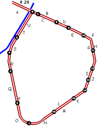
The Small Ring inner ring road, formally R20 and N0 is a series of roadways in central Brussels, Belgium, surrounding the historic city centre. The city centre is usually defined as the area within the Small Ring; this area is called the Pentagon due to its pentagonal shape. The pentagon forms the core of the City of Brussels municipality.
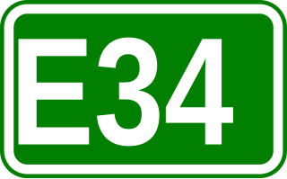
European route E34 forms part of the United Nations International E-road network. It connects Zeebrugge, the major seaport of Bruges, with Bad Oeynhausen, a German spa town located beside the River Weser at the eastern edge of North Rhine-Westphalia. At Bad Oeynhausen the E34 links to the E30, a major pan European east-west artery. It also passes, relatively briefly, through the Netherlands, following the southern by-pass of Eindhoven. Within Germany the route follows from south-west to north-east the full length of North Rhine-Westphalia.
Bundesautobahn 100 is an Autobahn in Germany.
The N1 is a national route that connects Brussels with Antwerp and the Dutch border near Wuustwezel.
The Greater Ring or Intermediate Ring in Brussels, Belgium is a set of roads in the shape of a ring, intermediate between the Small Ring and the main Brussels Ring motorway. The greater part of this set of roads is numbered R21 and is about 30 km long, compared to 8 km for the Small Ring and 80 km for the main Ring.
State Highway 74 is a state highway in New Zealand servicing the eastern suburbs of Christchurch. Mostly two-lane, it is composed of limited-access expressways, with part of the highway as the Christchurch-Lyttelton Motorway, and connects the city to its port town of Lyttelton.
European route E 233 is a west—east European Class-B road part of the International E-road network, running from Hoogeveen in the Netherlands to Cloppenburg in Germany, passing by the Dutch city of Emmen and the German city of Meppen. The road runs concurrently with four other roads over its course, first with the Dutch A37 from its western terminus to the German border, then with the German B402 up to Haselünne, from there on it follows B213 up to northern Cloppenburg, and on the last 2 kilometres (1.2 mi) of the B213 concurrency it also runs concurrent with B72, which it then follows up to its eastern terminus at the A1, which is also part of E 37. The road has a total length of 132 kilometres (82 mi), of which 41 kilometres (25 mi) in the Netherlands and 91 kilometres (57 mi) in Germany.
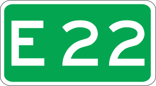
European route E 22 (E 22) is a west–east European route, running from Holyhead in the United Kingdom, through the Netherlands, Germany, Sweden and Latvia, to Ishim in Russia.
A bicycle highway, also known as a cycling superhighway, fast cycle route or bike freeway, is an informal name for a bicycle path that is meant for long-distance traffic. There is no official definition of a bicycle highway. The characteristics of a cycle motorway mentioned by authorities and traffic experts include an absence of single-level intersections with motorized traffic, a better road surface and the absence of traffic lights. Bicycle highways are mentioned in connection with traffic jam. Owing to higher average speeds than normal cycling infrastructure, they provide an alternative to the car in commuter traffic. Often a cycle motorway follows the route of a railway or other linear infrastructure.
This page is based on this Wikipedia article Text is available under the CC BY-SA 4.0 license; additional terms may apply. Images, videos and audio are available under their respective licenses.