A4 motorway (Switzerland)

Last updated

A4Swiss.svg
A4
Autobahn a4.png
Location of the A4 within Switzerland
Route information
Length165 km (103 mi)
Location
Country Switzerland
Highway system

The A4 motorway in Switzerland begins from Schaffhausen, in northern Switzerland, and travels southward into central Switzerland. [1]

Contents

The A4 between Rotkreuz and Zug (August 2004 image) A4 Switzerland.jpg
The A4 between Rotkreuz and Zug (August 2004 image)

The general route of A4 is: Bargen - Schaffhausen - Winterthur - Zürich - Central Switzerland.

Route description

A4 motorway bridge over the Rhine at Schaffhausen. Schaffhausen Schraegseilbruecke.jpg
A4 motorway bridge over the Rhine at Schaffhausen.

The A4 starts out as an Autostrasse road at the border crossing Bargen / Neuhaus am Randen, at the border to Germany, crossing a suspension bridge at Schaffhausen over the Rhine, and continues through Zurich's wine country to Winterthur. Between Winterthur and Zurich, the A4 runs together with the developed A1 Autobahn (motorway). From Zurich the branching east from the A4 and the A1 via the so-called Nordring the motorway interchange Limmattal, the motorway runs from where the A4 and A3, since 4 May 2009, joined to the Western Bypass of Zurich; until May 2009 this section ended for the motorway junction Birmensdorf. In November 2009 the opening of the A4 in Knonaueramt between the branches of Zurich West is planned, at Blegi Cham. From Blegi, the A4 goes on to Schwyz and ends as an Autostrasse road at Brunnen.

The continuation of the N4 national road that leads from Brunnen to Altdorf in the canton of Uri, has the status of a third-class national highway, with the physical role of a main road. The tunnel opened in 2005, is again shown as Flüelen Bypass Highway; yet the connection to the A2, however, remained as a non-main road intersection.

Expansion projects

Mini-Highway Flurlingen Andelfingen

On 20 October 2006, the Swiss Federal Department of Environment, Transport, Energy and Communications (DETEC) started a project to strengthen the implementation of the two-lane national highway between Flurlingen and Andelfingen, officially approved as a four-lane mini-freeway. The expansion will cost about 140 million Swiss francs. Thus the large volume of traffic is taken into account.

In the summer of 2007, construction work began on the mini-freeway. The completion and release of the developed part is planned for 20 October 2010.

Mini Highway Andelfingen branching Winterthur North

According to a media release from the Federal Roads Authority (Winterthur branch), for the year 2014/2015, the expansion of the previously two-lane section of Route Andelfingen to Winterthur North Branch, into a four-lane mini-freeway, is also officially approved.

Galgenbucktunnel

In May 2007, the Government of the Canton Schaffhausen presented the design project for the Galgenbuck-tunnel. The tunnel serves as a two-lane bypass the town of Neuhausen Rhine Falls. Currently, over 25,000 vehicles travel daily through Neuhausen. After commissioning, it will be only half the traffic. The tunnel has been listed since 1970 in the master plan.

The Islisberg-tunnel inside, showing gradual slope. Islisbergtunnel.jpg
The Islisberg-tunnel inside, showing gradual slope.

From Schaffhausen south, the A4 will create a 1,138-metre (3,734 ft) long tunnel with a slope of 4.5 percent, through the Galgenbuck Klettgau to the main road into the 13th link with the A4 intersections. In the service duct beneath the roadway, an escape tunnel has been built. Since this law concerns the transformation of a motorway connection, the federal government provides, under the new system of financial and division of tasks between the Confederation and the cantons, the full costs of approximately CHF 175 million. Construction is planned for summer 2010, with entry into service in 2014.

Reclassifying main road 15 as a national road

At the federal level, under the title "development of the national road network" (a revision of the WHO, "the Federal Decree") work has been performed on the national road network since 21 June 1960. During the consultation, the Federal Council in mid-2008 had invited the cantons to submit comments.

The so-called "New network decision" provides for the adjustment of the road network in the canton of Schaffhausen before the actual transit traffic. Ending on barges crossing the national highway 4 is obtained on the German side of any road performance, the transit traffic in the direction of Stuttgart, called on the cantonal main road 15 (J15), carried out through the border crossing Thayngen, and then removed from the German federal highway 34, which for Bundesautobahn 81 leads.

The main road 15 is, therefore, planned for 1 January 2010 from the junction to the border Mutzentäli Thayngen / Bietingen to be reclassified to the National Road, and the N4 today in return from the connector Schaffhausen Swiss border, to Bargen / Neuhaus am Randen, will be reclassified as the cantonal main road. The castling of the J15 shall be known N4/A4; the N4 is the new main road 4, while the old main road 4 can be in turn re-classified as the side street.

The Canton of Schaffhausen agreed in principle to the project, with the opinion on 15 September 2008 unanimously (69: 0 votes) adopted. Since the cantonal constitution in the case of the planned new recording of a main road into the national motorway network also requires a referendum for an opinion, this was held on 30 November 2008 and by 88.9% Yes votes (23,974: 2,988 votes) also confirmed.

Compared to the previous state, with the "new network" decision, the national motorway network in the canton of Schaffhausen, is approximately 7.2 kilometres (4.5 mi) shorter. The compensation-eligible main-road network has increased, however, due to the slightly longer course of the N4 towards the H4, and the inclusion of Klettgau Street (Hauptstrasse 13), as a longer total of 19.8 kilometres (12.3 mi).

The connections to the present main road number 15 are incorporated into the existing system of N4/A4. The future course is:

Junction list

Exits and structures
Bundesstrasse 27 number.svg B 27 Germany

Autostrasse A4
AB-Maut-Grenze.svg Border-crossing at Oberbargen/Neuhaus
am Randen
AB-AS.svg (1) Bargen
AB-AS.svg (2) Schaffhausen Schweizersbild
AB-Kreuz.svg AB-AS.svg (3)Junction Mutzentäli (T15)
AB-AS.svg (4) Schaffhausen Nord
AB-Tunnel.svg
AB-Tunnel.svg Fäsenstaub-Tannerberg (1460 m)
AB-AS.svg (5) Schaffhausen Süd
AB-Brucke.svg
AB-Tunnel.svg Flurlingen/Cholfirst (1250 m)
AB-AS.svg (6) Flurlingen
AB-AS.svg (7) Uhwiesen
AB-AS.svg (8) Benken
AB-AS.svg (9) Trüllikon
AB-AS.svg (10) Kleinandelfingen
AB-AS.svg (11) Adlikon
AB-AS.svg (12) Henggart
Autostrasse A4

End
AB-Vzw.svg (13)Junction Winterthur Nord A1Swiss.svg A 1
AB-AS.svg (14) Winterthur Wülflingen
AB-AS.svg (15) Winterthur Töss
AB-Tank.svg AB-Rast.svg Kempthal
AB-AS.svg (16) Effretikon
(Rest area) Baltenswil
AB-Kreuz.svg AB-AS.svg (17)Autobahnkreuz Brüttisellen A53Swiss.svg A 53
AB-AS.svg (18) Wallisellen
AB-Vzw.svg (19)Junction Zürich Ost A1LSwiss.svg A 1L
AB-Vzw.svg (20)Junction Zürich Nord A51Swiss.svg A 51
AB-Tunnel.svg Stelzen (380 m)
AB-AS.svg (21) Zürich Seebach
(Reste area) Büsisee
AB-AS.svg (22) Zürich Affoltern
AB-Tunnel.svg Gubrist (3230 m)
AB-AS.svg (23) Weiningen
AB-Kreuz.svg (24)Autobahnkreuz Limmattal A1Swiss.svg A 1 A1HSwiss.svg A 1H A3Swiss.svg A 3
AB-AS.svg (25) Urdorf Nord
AB-Tunnel.svg Niederurdorf/Honeret (450 m)
AB-AS.svg (26) Urdorf Süd
AB-Tunnel.svg Eggrain (480 m)
AB-AS.svg (27) Uitikon
AB-Tunnel.svg Hafnerberg (1385 m)
AB-AS.svg (28) Birmensdorf
End

Zeichen 123 - Baustelle, StVO 1992.svg AB-Tunnel.svg Aescher (2160 m) - construction (2008)
Zeichen 123 - Baustelle, StVO 1992.svg AB-Vzw.svg (29)Junction Zürich WestA3Swiss.svg A 3 - construction
(2008/2009)
Zeichen 123 - Baustelle, StVO 1992.svg AB-AS.svg (30) Wettswil - im Bau (2009)
Zeichen 123 - Baustelle, StVO 1992.svg AB-Tunnel.svg Islisberg (4950 m) - construction (2009)
Zeichen 123 - Baustelle, StVO 1992.svg AB-AS.svg (31) Affoltern am Albis - construction (2009)

Motorway end
AB-AS.svg Knonau - provisorisch bis 2009
Zeichen 123 - Baustelle, StVO 1992.svg AB-Vzw.svg (32)Junction Blegi A4ASwiss.svg A 4A - in work (2009)
AB-AS.svg (33) Cham
AB-Vzw.svg (34)Junction Rütihof / Holzhäusern A14Swiss.svg A 14
AB-AS.svg (35) Rotkreuz
AB-AS.svg (36) Küssnacht
AB-AS.svg (37) Arth
AB-Tunnel.svg Engiberg (263 m)
AB-Tunnel.svg Schönegg (197 m)
AB-AS.svg (38) Goldau
AB-AS.svg (39) Schwyz
AB-AS.svg (40) Brunnen Nord
Motorway end

Autostrasse A4
AB-Tunnel.svg Mosi (1080 m)
AB-AS.svg (41) Brunnen Süd
Autostrasse A4

Hauptstrasse N4 (Axenstrasse)

Autostrasse A4
AB-AS.svg (42)   Flüelen
AB-Tunnel.svg Umfahrung Flüelen (2600 m)
Autostrasse A4

Hauptstrasse N4
AB-AS.svg AB-Vzw.svg   (44)Junction Altdorf / Flüelen A2Swiss.svg A 2

A2Swiss.svg A 2
Autobahn part A4a
A4Swiss.svg A 4

Zeichen 123 - Baustelle, StVO 1992.svg AB-Vzw.svg    (1)Junction Blegi A4Swiss.svg A 4 - construction (2009)
AB-AS.svg (2) Zug
AB-AS.svg (3) Baar
AB-AS.svg (4)    Walterswil / Sihlbrugg
End

Related Research Articles

<span class="mw-page-title-main">Transport in Switzerland</span>

Switzerland has a dense network of roads and railways. The Swiss public transport network has a total length of 24,500 kilometres and has more than 2600 stations and stops.

<span class="mw-page-title-main">Rhine Falls</span> Swiss waterfall

The Rhine Falls is a waterfall located in Switzerland and the most powerful waterfall in Europe. The falls are located on the High Rhine on the border between the cantons of Schaffhausen (SH) and Zürich (ZH), between the municipalities of Neuhausen am Rheinfall (SH) and Laufen-Uhwiesen/Dachsen (ZH), next to the town of Schaffhausen in northern Switzerland.

<span class="mw-page-title-main">Canton of Schaffhausen</span> Canton of Switzerland

The canton of Schaffhausen, also canton of Schaffhouse, is the northernmost canton of Switzerland. The principal city and capital of the canton is Schaffhausen. The canton's territory is divided into three non-contiguous segments, where German territory reaches the Rhine. The large central part, which includes the capital, in turn separates the German exclave of Büsingen am Hochrhein from the rest of Germany.

<span class="mw-page-title-main">A13 motorway (Switzerland)</span> Motorway in Switzerland

The A13 is a motorway, at times an Autostrasse (expressway), which runs from St. Margrethen in northeastern Switzerland through to Ascona in southern Switzerland, crossing the main chain of the Alps in the Grisons area. It is the southern half of European route E43.

<span class="mw-page-title-main">Zurich S-Bahn</span> Train line network from Switzerland

The Zurich S-Bahn system is a network of rail lines that has been incrementally expanded to cover the ZVV area, which comprises the entire canton of Zurich and portions of neighbouring cantons, with a few lines extending into or crossing the territory of southern Germany. The network is one of many commuter rail operations in German speaking countries to be described as an S-Bahn. The lines connect with services of Aargau S-Bahn to the West, Basel S-Bahn and Schaffhausen S-Bahn to the North, St. Gallen S-Bahn to the East, and Lucerne S-Bahn/Zug Stadtbahn to the South, as well as with InterCity, InterRegio and RegioExpress services at major junction stations.

<span class="mw-page-title-main">Cholfirst Tunnel</span> Road tunnel in Switzerland

The Cholfirst Tunnel is a tunnel in Switzerland. The tunnel lies in the northern canton of Zuerich, and forms part of the Autostrasse A4. It was completed in 1996, and is 1,260 metres (4,130 ft) long.

<span class="mw-page-title-main">Neuhausen am Rheinfall</span> Municipality in Schaffhausen, Switzerland

Neuhausen am Rheinfall is a town and a municipality in the canton of Schaffhausen in Switzerland. The town is close to the Rhine Falls, mainland Europe's largest waterfall.

Switzerland has a two-class highway system: motorways with separated roads for oncoming traffic and a standard maximal speed limit of 120 kilometres per hour (75 mph), and expressways often with oncoming traffic and a standard maximal speed limit of 100 kilometres per hour (62 mph).

<span class="mw-page-title-main">Thurbo</span> Swiss railway company

Thurbo is a railway company with mostly S-Bahn-style services in Switzerland, southern Germany, and northwestern Vorarlberg, Austria, jointly owned by Swiss Federal Railways (90%) and the canton of Thurgau.

<span class="mw-page-title-main">A16 motorway (Switzerland)</span> Motorway in Switzerland

The A16, a motorway in north-central Switzerland, is a divided freeway connecting the border to France to the A5 motorway, 84 kilometres (52 mi) to the south on the Swiss plateau.

<span class="mw-page-title-main">High Rhine Railway</span> Railway line in Germany and Switzerland

The High Rhine Railway is a Deutsche Bahn railway line from Basel Badischer Bahnhof in the city of Basel to Konstanz on Lake Constance. It was built by the Grand Duchy of Baden State Railways as part of the Baden Mainline, which follows the Rhine upstream from Mannheim Hauptbahnhof to Konstanz. The line derives its name from the High Rhine, which it follows between Basel and Waldshut and on a short section in Schaffhausen.

<span class="mw-page-title-main">S12 (ZVV)</span> Railway service in Switzerland

The S12 is a regional railway line of the S-Bahn Zürich on the Zürcher Verkehrsverbund (ZVV), Zürich transportation network. The S12 is one of the network's lines connecting the cantons of Zürich, Aargau, Schaffhausen, Thurgau and St. Gallen.

<span class="mw-page-title-main">Winterthur railway station</span> Railway station in Winterthur, Switzerland

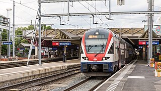
Winterthur railway station is the principal railway station of Winterthur, in the Swiss canton of Zürich. The station is listed on the Swiss Inventory of Cultural Property of National Significance.

<span class="mw-page-title-main">Oberwinterthur railway station</span> Railway station in Switzerland

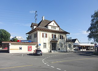
Oberwinterthur railway station is a railway station that serves Oberwinterthur, which is district number 2 in Winterthur, a city in the Canton of Zurich, Switzerland.

<span class="mw-page-title-main">S24 (ZVV)</span> Railway service in Switzerland

The S24 is a regional railway line of the Zürich S-Bahn of the Zürcher Verkehrsverbund (ZVV), Zürich transportation network. The line was significantly extended in June 2014, and again in December 2015, and has subsumed the former S21 line previously providing service in parts of its extended route.

<span class="mw-page-title-main">Schaffhausen railway station</span> Railway station in Switzerland

Schaffhausen railway station is a railway station in Schaffhausen, the capital of the Swiss canton of Schaffhausen. The station is jointly owned by the Swiss Federal Railways (SBB CFF FFS) and Deutsche Bahn (DB), and is served by trains of both national operators, as well as trains of the Swiss regional operator Thurbo.

<span class="mw-page-title-main">Rheinfall Railway</span> Swiss railway line

The Rheinfall Railway is a railway line in Switzerland. The line links Winterthur in the canton of Zurich with Schaffhausen in the canton of Schaffhausen. The Rheinfall Railway was constructed by the independent Rheinfallbahn-Gesellschaft.

<span class="mw-page-title-main">Eglisau–Neuhausen railway line</span> Swiss railway line that crosses part of Germany

The Eglisau–Neuhausen railway line is a cross-border railway line in Germany and Switzerland. It links Eglisau in the Swiss canton of Zurich with the city of Schaffhausen in the Swiss canton of Schaffhausen, crossing some 8 kilometres (5.0 mi) of the German state of Baden-Württemberg in between. It thus crosses the Germany–Switzerland border twice. The line is 17.88 kilometres (11.11 mi) long, standard gauge and electrified at 15 kV  16.7 Hz AC supplied by overhead line. It is formed of a mixture of single and double track sections.

<span class="mw-page-title-main">Zurich–Winterthur railway</span> Railway line in Switzerland

The Zurich–Winterthur railway is Switzerland's busiest railway line. Opened in 1855, it runs from Zürich Hauptbahnhof to Winterthur via several routes. It is a bottleneck in Swiss rail transport. Practically all lines of the core network of the Zurich S-Bahn use parts of this line.

<span class="mw-page-title-main">Hauptstrasse 13</span> Road in Switzerland

The Hauptstrasse 13 is a main road (“Hauptstrasse”) in the Swiss cantons of Schaffhausen, Zürich, Thurgau, St. Gallen, Grisons and Ticino. This main road begins at the German border at Trasadingen at the Bundesstraße 34 and ends at the Strada Statale 34 at the Italian border at Brissago. Between the border crossing Trasadingen / Erzingen and the A4 at Schaffhausen it is part of European route E54. The total length of Hauptstrasse 13 is approximately 320 kilometers.

References

  1. Tiefbauamt Document, 2009-01-22, web (PDF): SH-TBauamt [ permanent dead link ].

47°24′55″N8°34′29″E / 47.415384°N 8.574615°E / 47.415384; 8.574615