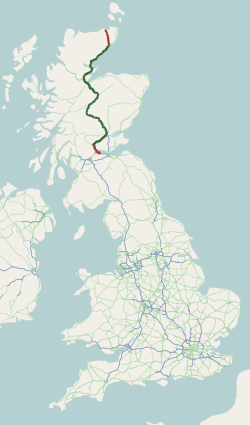
The A9 is a major road in Scotland running from the Falkirk council area in central Scotland to Scrabster Harbour, Thurso in the far north, via Stirling, Bridge of Allan, Perth and Inverness. At 273 miles (439 km), it is the longest road in Scotland and the fifth-longest A-road in the United Kingdom. Historically it was the main road between Edinburgh and John o' Groats, and has been called the spine of Scotland. It is one of the three major north–south trunk routes linking the Central Belt to the Highlands – the others being the A82 and the A90.
The A90 road is a major north-to-south road in eastern Scotland, running from Edinburgh to Fraserburgh, through Dundee and Aberdeen. Along with the A9 and the A82 it is one of the three major north–south trunk roads connecting the Central Belt to northern destinations. The A90 is not continuous, separated between Dalmeny and Perth by the M90.

The M90 is a motorway in Scotland. It runs from Junction 1A of the M9 motorway, south of the Queensferry Crossing, to Perth. It is the northernmost motorway in the United Kingdom. The northern point goes to the western suburbs of Perth at Broxden. A small part of the M90 was originally numbered as the M85 motorway.

The A96 is a major road in the north of Scotland.
The Strathspey Railway (SR) in Badenoch and Strathspey, Highland, Scotland, operates a ten-mile (16 km) heritage railway from Aviemore to Broomhill, Highland via Boat of Garten, part of the former Inverness and Perth Junction Railway which linked Aviemore with Forres. It is one of only a handful of former primary/secondary main lines to be preserved in Britain today.

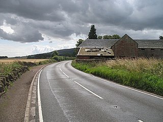
The A99 road is entirely within the former county of Caithness in the Highland of Scotland. It runs generally north/northeast from the A9 at Latheron to Wick and to the A836 at John o' Groats. It was part of the A9 until the A9 classification was transferred to what had been the A895-A882 link between Latheron and Thurso. Between Latheron and Wick it follows, mostly, the route of one of Telford's roads.

Burnside is a predominantly residential area of Thurso, Caithness, in the Highland council area of Scotland.
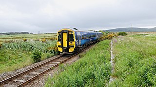
The Far North Line is a rural railway line entirely within the Highland area of Scotland, extending from Inverness to Thurso and Wick. As the name suggests, it is the northernmost railway in the United Kingdom. The line is entirely single-track, with only passing loops at some intermediate stations allowing trains to pass each other. Like other railway lines in the Highlands and northern Lowlands, it is not electrified and all trains are diesel-powered.

The A897 single track road is entirely within the Highland council area of Scotland. It runs generally north from the A9 at Helmsdale to the A836 near Halladale Bridge, east of Melvich. The road passes through or near Kildonan, Kinbrace and Forsinard, and has a junction with the B871 at Kinbrace. It also passes through Achiemore.

The A949 is a major road in Sutherland, in the Highland area of Scotland. It has staggered junctions with the A9. From the A949 the A9 runs (1) generally north to Thurso and (2) generally south to Tain, Inverness, Perth, Stirling and Falkirk.

The River Beauly is a river in the Scottish Highlands, about 15 km west of the city of Inverness.
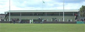
Victoria Park is a football ground in Buckie in north-east Scotland, which is the home ground of Highland Football League side Buckie Thistle. It is located at the junction of Midmar Street and South Pringle Street, 0.5 miles (0.8 km) from the town centre. The ground has a capacity of 3,000 with 400 seated.

The A98 road is a major coastal road of northeast Scotland passing through Moray and Aberdeenshire. The A98 is no longer a primary route, with this status being removed shortly after the A92 was renumbered A90.
The A912 is a major road in both Perth and Kinross and Fife, Scotland. It runs from the A9 in Perth, in the north, to the A92 at Muirhead, in the south. Part of it was formerly part of the A90.

The A803 is a road in central Scotland. It runs from Glasgow to Champany Corner, three miles (4.8 km) due north-east of Linlithgow).

The A835 is a road in the Scottish Highlands linking Inverness to Ullapool and the Far North of Scotland.

The A950 is a road in rural Aberdeenshire, Scotland. It runs for 19.2 miles (30.9 km), and was first classified in 1922.

The A832 is a road in the Scottish Highlands, linking Cromarty, on the east coast, to Gairloch on the west coast, and beyond Gairloch to Braemore Junction. It is 126 miles (203 km) long and runs entirely in the former county of Ross and Cromarty. The road forms part of the Wester Ross Coastal Trail.
Farmtown is a village in the Moray council area of Scotland.

The River Dulnain is a major left bank tributary of the River Spey in northeast Scotland. It rises in the eastern part of the Monadhliath Mountains and flows in a generally northeastward direction through uninhabited country to Sluggan, where it is crossed by Sluggan Bridge, constructed by General Wade to carry a military road. Turning more easterly, the Dulnain passes beneath the modern A9 road which bypasses Carrbridge, the mainline railway and, in Carrbridge itself, the Carrbridge Packhorse Bridge that gives the village its name and the bridge carrying the B9153 road. The final section flowing east-northeast to the village of Dulnain Bridge is accompanied by the A938 road. The river empties into the Spey after passing beneath the A95 road and the disused bridge of the former Strathspey railway.

