Galicia is an autonomous community of Spain and historic nationality under Spanish law. Located in the northwest Iberian Peninsula, it includes the provinces of A Coruña, Lugo, Ourense, and Pontevedra.

Ourense is a province of Spain, in the southeastern part of the autonomous community of Galicia. It is bordered by the provinces of Pontevedra to the west, Lugo to the north, León and Zamora, to the east, and by Portugal to the south. With an area of 7,278 square km., it is the only landlocked province in Galicia. The provincial capital, Ourense, is the largest population centre, with the rest of the province being predominantly rural.

Ribeira is the capital of the comarca of Barbanza, in the province of A Coruña in the autonomous community of Galicia in northwestern Spain. The capital and most populous urban center is Santa Uxía de Ribeira. Another of its major points is the center of San Martin de Oleiros. The municipality is administratively divided into nine civil parishes: Aguiño, Artes, Carreira, Castiñeiras, Corrubedo, Oleiros, Olveira, Palmeira and Ribeira.

The Sil is a river in León and Galicia, Spain, a tributary of the Miño. Its total length is 225 kilometres (140 mi). The source of the Sil is in the Cantabrian Mountains in the Leonese town of Villablino. It flows through the provinces of León and Ourense. The largest city on the Sil is Ponferrada (León). The Sil flows into the Miño upstream from Ourense.

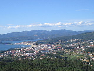
The Rías Baixas are a series of four estuarine inlets located on the southwestern coast of Galicia, Spain. They are the Ría de Muros e Noia, the Ría de Arousa, the Ría de Pontevedra, and the Ría de Vigo. The northernmost Rías Baixas begin below Cape Finisterre while the southernmost borders the Portuguese coast, taking up the southern part of the Province of Coruña and the entire Province of Pontevedra. Its capital is the city of Pontevedra. Due to unique conditions, the Rías Baixas are rich in marine life which helps the fishing and aquaculture industry of the area. Beaches, marinas, distinctive towns, and plenty of water activities attract tourists, providing another source of income.

Cambados is a municipality in Galicia, Spain in the province of Pontevedra. It is known for its historical monuments, its seafood and the famous white wine, Albariño.
Vilagarcía de Arousa is a municipality in the province of Pontevedra, in Galicia, Spain. As of 2014 it has a population of 37,712, being ninth largest town in Galicia.

The Cíes Islands are an archipelago off the coast of Pontevedra in Galicia, Spain, in the mouth of the Ria de Vigo. They were declared a Nature Reserve in 1980 and are included in the Atlantic Islands of Galicia National Park created in 2002.

The Ría de Arousa is a ria, a saline estuary, that forms a firth situated on Galicia, Spain. It is one of the five Rías Baixas. The Ría de Arousa estuary is the largest of the estuaries of Galicia. It is part of the Rias Baixas and is located between the estuary of Muros and Noia to the north and the Pontevedra estuary to the south. The peninsulas of Barbanza, in the province of A Coruña, and O Salnés, in the province of Pontevedra, are those who define their coasts on the north and south, respectively. Ría de Muros and Noia is located in north.

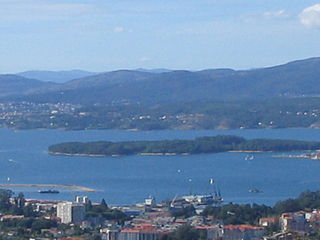
The Ons Island is the main island of a small archipelago in the Ria de Pontevedra in Galicia, Spain. Ons belongs administratively to the municipality of Bueu, which has a regular ferry boat connection to the island, as have the mainland towns of Portonovo, Sanxenxo, Marín and Aldán. In 2020, lightning due to Subtropical Storm Alpha started a forest fire.

The Atlantic Islands of Galicia National Park is the only national park located in the province of Pontevedra, in the autonomous community of Galicia, Spain. It comprises the archipelagos of Cíes, Ons, Sálvora and Cortegada. The park covers a land area of 1,200 ha and a sea area of 7,200 ha. It is the tenth most visited national park in Spain. It was the thirteenth national park to be established in Spain. Since 2021 it has been designated as a protected Ramsar site.

Sálvora Island is a small island located on the Ría de Arousa, coast of Galicia, Spain. It belongs to the municipality of Santa Uxía de Ribeira and is integrated in the Atlantic Islands of Galicia National Park. It is separated from the mainland by a distance of about 3 kilometers to the north. It occupies about 190 hectares and has a maximum height of 71 meters. Almost the entire perimeter of the island is rocky but has three beaches of fine white sand. Since 2001 it has been integrated into the Atlantic Islands of Galicia National Park.
Cortegada is an almost tidal island in a coastal inlet near Pontevedra in Galicia, Spain. It is part of the Atlantic Islands of Galicia National Park.

The Ulla is a river in Galicia, Spain.

The geography of Galicia (Spain) is characterized by the contrast between the low altitude coastal relief and, further inland, by the higher altitude of the Galician Massif which itself offers contrasts between the morphology of the high northern plains and the southern mountains and valleys.

The Island of San Simón, which alongside San Antón and other islets, is part of the San Simón archipelago in the Vigo estuary, Spain. The islands are one of five parts of the parish of Cesantes in the municipality of Redondela. As of 2021, San Simón is uninhabited.

The Covo Island, better known as the Island of Sculptures or Illa das Esculturas in Galician, is a park and island located near the mouth of the Lérez River, in Pontevedra, Spain. It has an area of 70,000 m² and is connected to both banks of the river by footbridges and pedestrian bridges. It is the largest and most important open-air museum in Galicia and one of the most important in Spain.

The Tambo Island is an island in the middle of the Pontevedra bay, in Spain. It belongs to the municipality of Poio, from which it is separated by a 1.1 km long but shallow channel. Its surface area is 0.28 km², with a maximum height of 80 m, although its entire central part is over 50 metres high. Its perimeter reaches 4 km.

The University Hospital Complex of Pontevedra (CHOP) is a public health institution and a teaching hospital established in 2012 that provides health services to the specialized region of the city of Pontevedra in Spain. It depends on the Galician Healthcare Service, and consists of three hospitals and one specialty center.
The Galician Institute of Aquaculture Training is an educational body dependent on the Dirección Xeral de Innovación e Desenvolvemento of the Consellería de Pesca e Asuntos Marítimos of the Galician autonomous government. It is co-financed by the European Social Fund. Courses are taught for obtaining the certificates of shell fisherman, aquaculturist and specialists in marine cultures.