Portas

Last updated
Portas
Escudo de Portas.svg
Situacion Portas.PNG
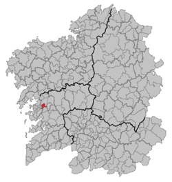
Situation of Portas within Galicia
Country Flag of Spain.svg  Spain
Autonomous community Flag of Galicia.svg  Galicia
Province Pontevedra
Comarca Caldas
Area
  Total23 km2 (9 sq mi)
Population
 (2018) [1]
  Total2,984
  Density130/km2 (340/sq mi)
Time zone UTC+1 (CET)
  Summer (DST) UTC+2 (CET)

Portas is a small municipality in the province of Pontevedra, in the autonomous community of Galicia, Spain. It belongs to the comarca of Caldas.

Parroquias

It is made up of four parroquias (parishes):

Related Research Articles

<span class="mw-page-title-main">Arctic Archipelago</span> Group of islands in the Arctic Ocean, off the coast of northern Canada

The Arctic Archipelago, also known as the Canadian Arctic Archipelago, is an archipelago lying to the north of the Canadian continental mainland, excluding Greenland and Iceland.

<span class="mw-page-title-main">Ancín – Antzin</span> Place in Navarra, Spain

Ancín is a town and municipality located in the province and autonomous community of Navarra, northern Spain.

<span class="mw-page-title-main">Añorbe</span>

Añorbe is a town and municipality located in the autonomous community of Navarre, northern Spain.

<span class="mw-page-title-main">Caparroso</span>

Caparroso is a town and municipality located in the province and autonomous community of Navarre, in the north of Spain.

<span class="mw-page-title-main">Enériz</span>

Enériz is a town and municipality located in the province and autonomous community of Navarre, northern Spain.

<span class="mw-page-title-main">Úcar</span>

Úcar is a town and municipality located in the province and autonomous community of Navarre, northern Spain.

<span class="mw-page-title-main">Remolino</span> Town in Caribbean, Colombia

Remolino is a town and municipality of the Colombian Department of Magdalena. Founded between 1752 and 1776 by Fernando de Mier y Guerra. Erected municipality in 1814.

<span class="mw-page-title-main">Bochalema</span> Municipality and town in Norte de Santander Department, Colombia.

Bochalema is a Colombian municipality and town located in the department of North Santander.

<span class="mw-page-title-main">Dagua</span> Municipality and town in Valle del Cauca Department, Colombia

Dagua is a town and municipality located in the Department of Valle del Cauca, Colombia.

Camponaraya is a village and municipality located in the region of El Bierzo. According to the 2010 census (INE), the municipality has a population of 4,230 inhabitants.

<span class="mw-page-title-main">Busto de Bureba</span> Municipality and town in Castile and León, Spain

Busto de Bureba is a municipality and town located in the province of Burgos, Castile and León, Spain. According to the 2004 census (INE), the municipality has a population of 216 inhabitants.

<span class="mw-page-title-main">Carcedo de Bureba</span> Municipality in Castile and León, Spain

Carcedo de Bureba is a municipality located in the province of Burgos, Castile and León, Spain. According to the 2004 census (INE), the municipality had a population of 46 inhabitants.

<span class="mw-page-title-main">Castrillo del Val</span> Municipality in Castile and León, Spain

Castrillo del Val is a municipality located in the province of Burgos, Castile and León, Spain. It is in the valley of the River Arlanzón.

<span class="mw-page-title-main">Madrigal del Monte</span> Municipality in Castile and León, Spain

Madrigal del Monte is a municipality located in the province of Burgos, Castile and León, Spain. According to the 2004 census (INE), the municipality has a population of 209 inhabitants.

<span class="mw-page-title-main">Piérnigas</span> Municipality and town in Castile and León, Spain

Piérnigas is a municipality and town located in the province of Burgos, Castile and León, Spain. According to the 2004 census (INE), the municipality has a population of 38 inhabitants.

<span class="mw-page-title-main">Poza de la Sal</span> Municipality and town in Castile and León, Spain

Poza de la Sal is a municipality and town located in the province of Burgos, Castile and León, Spain. According to the 2004 census (INE), the municipality has a population of 387 inhabitants.

Carrizo de la Ribera is a town and municipality in the Province of León, Castile and León, Spain. According to the 2008 census (INE), the municipality has a population of 2,554 inhabitants. It is situated in the western bank of the Órbigo River. In addition to Carrizo, the municipality includes the villages of Huerga del Río, La Milla del Río, Quiñones del Río and Villanueva de Carrizo.

<span class="mw-page-title-main">Piikani 147</span> Indian reserve of the Piikani in Alberta, Canada

Piikani 147, formerly Peigan 147, is an Indian reserve of the Piikani Nation in Alberta. It is located 61 km (38 mi) west of the City of Lethbridge. It has a land area of 426.992 km2 (164.863 sq mi), making it the fourth-largest Indian reserve in Canada, and lies at an elevation of 1,046 m (3,432 ft). The Canada 2011 Census reported a population of 1,217 inhabitants. It is bordered by the Municipal District of Willow Creek No. 26 on its north and east, and by the Municipal District of Pincher Creek No. 9 on its west and south. The nearest outside communities are Fort Macleod and Pincher Creek.

<span class="mw-page-title-main">Valladolid (Senate constituency)</span>

Valladolid is one of the 59 constituencies represented in the Senate of Spain, the upper chamber of the Spanish parliament, the Cortes Generales. The constituency elects four senators. Its boundaries correspond to those of the Spanish province of Valladolid. The electoral system uses an open list partial block voting, with electors voting for individual candidates instead of parties. Electors can vote for up to three candidates.

<span class="mw-page-title-main">House of Romay</span> Spanish aristocratic family

The Romay family is a Spanish aristocratic family that descends from 8th-century pre-Reconquista Galicia, in northern Spain.

References

  1. Municipal Register of Spain 2018. National Statistics Institute.


42°35′N8°40′W / 42.583°N 8.667°W / 42.583; -8.667