
Madhubani district is one of the thirty-eight districts of Bihar, India, and is a part of Darbhanga division. Its administrative headquarters are located in Madhubani. The district has an area of 3,501 square kilometres (1,352 sq mi) and has a population of 4,487,379.

The Gandaki River, also known as the Narayani and the Gandak, is one of the major rivers in Nepal and a left bank tributary of the Ganges in India. Its total catchment area amounts to 46,300 km2 (17,900 sq mi), most of it in Nepal. In the Nepal Himalayas, it is notable for its deep canyon. The basin also contains three mountains over 8,000 m (26,000 ft), namely Dhaulagiri, Manaslu and Annapurna I. Dhaulagiri is the highest point of the Gandaki basin.
Dailekh District a part of Karnali Province, is one of the 77 districts of Nepal. The district, with Dailekh as its district headquarters, covers an area of 1,502 km2 (580 sq mi) and had a population of 225,201 in 2001 and 261,770 in 2011.

Lomanthang is a rural municipality in Mustang district in Gandaki Province of western Nepal. It is located at the northern end of the district, bordering the Tibet Autonomous Region of China to the north and Dalome rural municipality of Mustang in the south.

Waling Municipality, the heart of Syangja, is a small valley covered with hills formed on 27 January 1997 by merging of the then three VDCs namely Waling, Dhanubase and Pekhubaaghkhor. It is a town and municipality in the western hilly region of Nepal. It is in the Aadhikhola valley in Syangja District, Gandaki Zone of Nepal. Waling will be the first municipality to have houses all coloured with pink and will be named as Pink City. Waling has grabbed an award for the best municipality of the country.
Argal is a Village Development Committee in Baglung District in the Dhaulagiri Zone of central Nepal. It is located roughly 25 kilometres west of Baglung. At the time of the 1991 Nepal census it had a population of 2,148 and had 387 houses in the village.
Basantapur is a Village Development Committee in Baitadi District in Sudurpashchim Province of western Nepal. At the time of the 1991 Nepal census it had a population of 2,141 and had 366 houses in the village.
Jhor Mahankal is a village and former village development committee which is part of the Tokha municipality in Kathmandu District, Bagmati Province of central Nepal. It had a population of 4,103 in the 2011 Nepal census, with 873 households. Jhor Mahankal is known for Baruneshwar Gufa and its waterfalls. A number of clans live there, primarily the Adhikaris, Lamichanne, Dulals, Bidari, and Tamang. Jhor Mahankal is 7 kilometres (4.3 mi) from Kathmandu, with bus service from the Jhor bus station to Simalchour Syampati and Samakhushi and Ratna Park in Kathmandu.
Patarasi is a rural municipality located in Jumla District of Karnali Province of Nepal.

Siddhipur is a village and former Village Development Committee that is now part of Mahalaxmi Municipality in Bagmati Province of central Nepal. At the time of the 2021 Nepal census it had a population of 8194 living in 2009 individual households.
Narayan is a municipality located in Dailekh District of Karnali Province of Nepal.
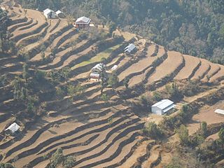
Kaskikot, commonly known as Kaski, is a Ward no. 24 of the Pokhara metropolitan city. It was earlier a part of the village development committee in Kaski District, a region in northern-central Nepal.

Tahoon is a village very development committee in Palpa District in the Lumbini Zone of southern Nepal. At the time of the 1991 Nepal census it had a population of 3776.
Arehalli is a village in the state of Karnataka in southern India.As per census 2011, the location code number of Arehalli is 615144. It is located in the Belur taluk of Hassan district in Karnataka, and is about 230 kilometres from the state capital Bangalore, and 146 kilometres from the chief port city of Mangalore. It is well connected by road through the city of Hassan. The nearest airport is Mangalore International Airport at 160 km, and the nearest major railway station is Hassan Junction railway station located at a distance of 46 km; Sakleshpura railway station is 17 km away.
The Mechi River is a trans-boundary river flowing through Nepal and India. It is a tributary of the Mahananda River.
'Tisaura'/Babhanpura is a village in Varanasi sadar tehsil, Varanasi district in Uttar Pradesh state in India, located 20 kilometres (12 mi) from the cantonment railway station in Varanasi and 12 kilometres (7.5 mi) from its airport. It is located 20.42 km from its District Main City Varanasi on the highway that connects it to Nepal, and 261 km from its State Main City Lucknow.
Narayan Wagle is a Nepali journalist and writer. He served as the editor of Kantipur Daily, one of Nepal's largest circulating newspapers, until 2008, and was the editor of Nagarik News until 18 May 2012. Wagle won the Madan Puraskar for his novel Palpasa Cafe in 2005.

Kodari is a small village located at the border with Tibet-China. The village is located at the end–point of the Arniko Highway, which connects Kodari with the capital city of Kathmandu. Kathmandu is 144 kilometres (89 mi) away from Kodari. Kodari is a major border crossing from Nepal into the Tibet Autonomous Region.

