
Banke District (Nepali: बाँके जिल्ला[bãke], a part of Lumbini Province, is one of the 77 districts of Nepal. The district, located in midwestern Nepal with Nepalganj as its district headquarters, covers an area of 2,337 km2 and had a population of 385,840 in 2001 and 491,313 in 2011. There are three main cities in the Banke District: Nepalganj, Kohalpur and Khajura Bajaar.

Bardiya District, one of the seventy-seven Districts of Nepal, is part of Lumbini Province of Nepal. The district, with Gulariya as its headquarters, covers an area of 2,025 km2 (782 sq mi) and according to the 2001 census the population was 382,649 in 2011 it has 426,576.
Dadeldhura district, a part of Sudurpashchim Province, is one of the seventy-seven districts of Nepal. The district, with Dadeldhura as its district headquarters, covers an area of 1,538 km2 (594 sq mi) and had a population of 126,162 in 2001 and 142,094 in 2011.

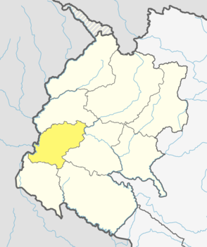
Jhapa is a district of Province No. 1 in eastern Nepal named after a Rajbanshi word "Jhapa" meaning "to cover" (verb). The latest official data, the 2011 Nepal Census, puts the total population of the district at 812,650. The total area of the district is 1606 square kilometres.
Kailali District, a part of Sudurpashchim Province in Terai plain, is one of the 77 districts of Nepal. The district, with Dhangadhi as its district headquarters, covers an area of 3,235 square kilometres (1,249 sq mi) and has a population 911,155 and ,(616,697 in 2001 census).

Lalitpur District (Nepali: ललितपुर जिल्लाListen , a part of Bagmati Province, is one of the seventy-seven districts of Nepal. The district, with Lalitpur as its district headquarters, covers an area of 396.92 km2 and has a population of 337,785. It is one of the three districts in the Kathmandu Valley, along with Kathmandu and Bhaktapur. Its population was 466,784 in the initial 2011 census tabulation. It is surrounded by Makwanpur, Bhaktapur, Kathmandu and Kavre.

Mahottari District, a part of Madhesh Province, is one of the seventy-seven districts of Nepal. The district, with Jaleshwar as its district headquarters, covers an area of 1,002 km2 (387 sq mi) and had a population of 553,481 in 2001, 627,580 in 2011 and 705,838 in 2021 census. Its headquarters is located in Jaleshwar, a neighbouring town of the historical city of Janakpur. The name Jaleshwar means the 'God in Water'. One can find a famous temple of Lord Shiva in Water there. Jaleshwar lies at a few kilometres distance from the Nepal-India border and has a majority Maithili population.
Makwanpur District(Nepali: मकवानपुर जिल्ला; Listen , a part of Bagmati Province, earlier a part of Narayani Zone, is one of the seventy-seven districts of Nepal. The district, with Hetauda as its district headquarter, as well as pradesh headquarter covers an area of 2,426 km2 and had a population of 392,604 in 2001 and 420,477 in 2011.

Okhaldhunga District is one of 14 districts of Province No. 1 in eastern Nepal. The district, with Okhaldhunga as its district headquarters, covers an area of 1,074.5 km2 (414.9 sq mi) and had a population of 156,702 in 2001 and 147,984 in 2011.

Parsa District (Nepali: पर्सा जिल्लाListen , a part of Madhesh Province in Terai plain, is one of the seventy-seven districts of Nepal. The district, with Birgunj as its district headquarters, covers an area of 1,353 km2 and has a population of 497,219. According to the locals, Parsa is named after Parashnath temple situated in Mahuwan.
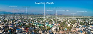
Damak, a city in eastern Nepal is one of the oldest municipalities in Jhapa District in Province No. 1 of Nepal. It is situated between the Ratuwa River in the east and the Maawa River in the west. It has Sivalik Hills in its north and ends with the intersection of Ratuwa River and Maawa River in the south. Mahendra Highway crosses this municipality nearly bisecting it. It is the largest city in Jhapa District as well as in Province No. 1 with a population of 75,743 in 2011 A.D

A Village Development Committee (VDC) in Nepal was the lower administrative part of its Ministry of Federal Affairs and Local Development. Each district had several VDCs, similar to municipalities but with greater public-government interaction and administration. There were 3,157 village development committees in Nepal. Each VDC was further divided into several wards depending on the population of the district, the average being nine wards.
Dullu is an urban Municipality in Dailekh District of Karnali Province in Nepal.
Shambhunath Municipality is a Town in Saptari District in the Sagarmatha Zone of south-eastern Nepal. Merging the existing Khoksar Parbaha, Shambhunath, Mohanpur, Bhangha, Basbalpur and Rampur Jamuwa village development committee this new municipality was formed on 18 May 2014. Kathauna Bazar is now finally head office of this new municipality. At the time of the 1991 Nepal census it had a population of 5168 people living in 933 individual households.
Duhabi is a municipality in Sunsari District in the Koshi Zone of south-eastern Nepal. At the time of the 2001 Nepal census it had a population of 17,574. Duhabi is situated in between Itahari and Biratnagar, on the bank of Budi River. It is the center of Sunsari–Morang industrial corridor.
Pathari Shanishchare (पथरी-शनिश्चरे) is a Municipality in Morang District in the Koshi Zone of south-eastern Nepal. It was formed by merging three existing village development committees i.e. Hasandaha, Pathari and Sanischare in May 2014.
Urlabari is a city and municipality in Morang District in the Koshi Zone of south-eastern Nepal. It is considered to be the second largest city in Morang District after Biratnagar. At the time of the 1991 Nepal census it had a population of 18,224. At the time of the 2011 Nepal census it had a population of 35,166 and 8,165 households.
Nepal conducted a widespread national census in 2011 by the Nepal Central Bureau of Statistics. Working with the 58 municipalities and the 3915 Village Development Committees at a district level, they recorded data from all the municipalities and villages of each district. The data included statistics on population size, households, sex and age distribution, place of birth, residence characteristics, literacy, marital status, religion, language spoken, caste/ethnic group, economically active population, education, number of children, employment status, and occupation.
Sundar Haraicha is a municipality in Morang District of Province No. 1 in Nepal. It is centered around Biratchowk town which is the gateway to Biratnagar. It borders Itahari Sub- Metropolitan city to the West, Dharan Sub- Metropolitan city to the Northwest and Belbari municipality to the East and is connected by the Mahendra Highway. It is one of the fastest growing cities in the Eastern Nepal and the second largest city of Morang district after Biratnagar with 121,305 inhabitants living in 26,677 households. It consists the town centres of Biratchowk and Gothgaun which are parts of the Greater Birat Development Area which incorporates the cities of Biratnagar-Itahari-Gothgau-Biratchowk-Dharan primarily located on the Koshi Highway in Eastern Nepal, with an estimated total urban agglomerated population of 804,300 people living in 159,332 households.

