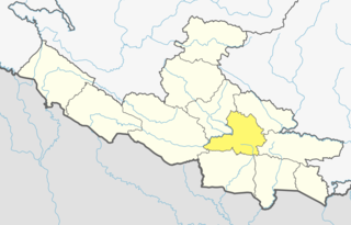
Arghakhanchi is one of the districts of Province No. 5 in Nepal. The district headquarter is Sandhikharka. The district covers an area of 1,193 km2 (461 sq mi) and has a population (2011) of 197,632. Its neighboring districts are Palpa in the east, Gulmi in the north, Kapilvastu District in the south and Pyuthan in the west.

Baglung District, a part of Gandaki Pradesh, is one of the seventy-seven districts of Nepal. The district, with Baglung as its district headquarters, covers an area of 1,784 km2 (689 sq mi) and has a population (2011) of 268,613.
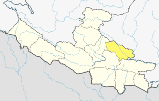
Gulmi District, a part of Province No. 5, is one of the seventy-seven districts of Nepal. The district, with Tamghas as its headquarters, covers an area of 1,149 km2 (444 sq mi), had a population of 296,654 in 2001, 280,160 in 2011 and 268,597 in 2016.
Wangla is a Market Center in Sandhikharka Municipality of Arghakhanchi District in the Lumbini Zone of southern Nepal. The former village development committee (VDC) was converted into a municipality on 18 May 2014 by merging the existing Sandhikharka, Wangla, Narapani, Khanchikot, Keemadada, Argha and Dibharna VDCs. At the time of the 1991 Nepal census, the town had a population of 5,142 living in 1,033 houses. At the time of the 2001 Nepal census, the population was 5,380, of which 66% was literate.
Amar Arbathok is a village and municipality in Gulmi District in the Lumbini Zone of centralNepal. At the time of the 1991 Nepal census it had a population of 1978 persons living in 387 individual households. there people are market go to gandaki dobata.Amari is a famous village.
Gulmi Arkhale is a business center in Resunga Municipality in Gulmi District in the Lumbini Zone of central Nepal. At the time of the 1991 Nepal census, it had a population of 6196 people residing in 1165 individual households.
Badagaun is a town and municipality in Gulmi District in the Lumbini Zone of central Nepal. At the time of the 1991 Nepal census it had a population of 7247 persons residing in 1305 individual households.
Bajhketeri is a village and municipality in Gulmi District in the Lumbini Zone of central Nepal. At the time of the 1991 Nepal census it had a population of 2984 persons living in 554 individual households.
Bhurmung (chhapchour) is a town and municipality in Gulmi District in the Lumbini Zone of central Nepal. At the time of the 1991 Nepal census it had a population of 4047 persons living in 784 individual households.
Darling is a village and municipality in Gulmi District in the Lumbini Zone of central Nepal. At the time of the 1991 Nepal census it had a population of 2465 persons living in 454 individual households.

Dhamir is a village in Gulmi District in the Lumbini Zone of Western Nepal. It is located at latitude 28°12′7.81″ N and longitude 83°9′32.66″ E. It lies 1143 meters above sea level. According to 2011 Nepal census, the total population of this village is 3,588 individuals living in 768 households. The census also noted some absent people; most are foreign employees employed overseas and in the Middle East. The male population is 1,563 and the female population is 2,025, causing a sex ratio of 77.19.
Isma Rajasthal is a Village Development Committee in Gulmi District in the Lumbini Zone of central Nepal. At the time of the 1991 Nepal census it had a population of 2974 persons living in 568 individual households.
Jaisithok is a village and municipality in Gulmi District in the Lumbini Zone of central Nepal. At the time of the 1991 Nepal census it had a population of 2938.
Kurgha is a village and municipality in Gulmi District in the Lumbini Zone of central Nepal. At the time of the 1991 Nepal census it had a population of 2988 persons residing in 556 individual households.
Neta is a village and municipality in Gulmi District in the Lumbini Zone of central Nepal. At the time of the 1991 Nepal census it had a population of 2375 persons residing in 451 individual households.
Palkikot is a village and municipality in Gulmi District in the Lumbini Zone of central Nepal. At the time of the 1991 Nepal census it had a population of 2085 persons living in 387 individual households.
Paudi Amarahi is a town and municipality in Gulmi District in the Lumbini Zone of central Nepal. At the time of the 1991 Nepal census it had a population of 4136 persons living in 742 individual households.
Siseni is a town and municipality in Gulmi District in the Lumbini Zone of central Nepal. At the time of the 1991 Nepal census it had a population of 3851 persons living in 720 individual households.
Maina Kaderi is a village development committee in Saptari District in the Sagarmatha Zone of south-eastern Nepal. At the time of the 2011 Nepal census it had a population of 3,206 people living in 554 individual households.
Galkot is a municipality in Baglung district of Gandaki province of Nepal. It consists of several VDCs. Nearby cities include Gulmi and Pokhara. Its geographic coordinates are 28°13'24"N 83°25'29"E.
