The Aare or Aar is the main tributary of the High Rhine and the longest river that both rises and ends entirely within Switzerland.

The geography of Switzerland features a mountainous and landlocked country located in Western and Central Europe. Switzerland's natural landscape is marked by its numerous lakes and mountains. It is surrounded by five countries: Austria and Liechtenstein to the east, France to the west, Italy to the south and Germany to the north. Switzerland has a maximum north–south length of 220 kilometres (140 mi) and an east–west length of about 350 kilometres (220 mi).

The Bernese Alps are a mountain range of the Alps located in western Switzerland. Although the name suggests that they are located in the Berner Oberland region of the canton of Bern, portions of the Bernese Alps are in the adjacent cantons of Valais, Fribourg and Vaud, the latter being usually named Fribourg Alps and Vaud Alps respectively. The highest mountain in the range, the Finsteraarhorn, is also the highest point in the canton of Bern.

The canton of Bern, or Berne, is one of the 26 cantons forming the Swiss Confederation. Its capital city, Bern, is also the de facto capital of Switzerland. The bear is the heraldic symbol of the canton, displayed on a red-yellow background.

The Jungfraujoch is a saddle connecting two major 4000ers of the Bernese Alps: the Jungfrau and the Mönch. It lies at an elevation of 3,463 metres (11,362 ft) above sea level and is directly overlooked by the rocky prominence of the Sphinx. The Jungfraujoch is a glacier saddle, on the upper snows of the Aletsch Glacier, and part of the Jungfrau-Aletsch area, situated on the boundary between the cantons of Bern and Valais, halfway between Interlaken and Fiesch.

The Grimsel Pass is a mountain pass in Switzerland, crossing the Bernese Alps at an elevation of 2,164 metres (7,100 ft). The pass connects the Haslital, the upper valley of the river Aare, with the upper valley of the Rhône. In so doing, and as the Aare is a tributary of the Rhine, the pass crosses the continental divide between the North Sea and the Mediterranean Sea.

Monte Rosa is a mountain massif in the eastern part of the Pennine Alps, on the border between Italy and Switzerland (Valais). The highest peak of the massif, amongst several peaks of over 4,000 m (13,000 ft), is the Dufourspitze, the second highest mountain in the Alps and western Europe, after Mont Blanc. The east face of the Monte Rosa towards Italy has a height of about 2,400 metres (7,900 ft) and is the highest mountain wall of the Alps.

The Bernese Oberland, sometimes also known as the Bernese Highlands, is the highest and southernmost part of the canton of Bern. It is one of the canton's five administrative regions. It constitutes the Alpine region of the canton and the northern side of the Bernese Alps, including many of its highest peaks, among which the Finsteraarhorn, the highest in both range and canton.

The Alps form a large mountain range dominating Central Europe, including parts of Italy, France, Switzerland, Liechtenstein, Austria, Slovenia, Germany and Hungary.

Titlis is a mountain of the Uri Alps, located on the border between the cantons of Obwalden and Bern. At 3,238 metres (10,623 ft) above sea level, it is the highest summit of the range north of the Susten Pass, between the Bernese Oberland and Central Switzerland. It is mainly accessed from Engelberg (OW) on the north side and is famous as the site of the world's first rotating cable car. The cable car system connects Engelberg to the summit of Klein Titlis through the three stages of Gerschnialp, Trübsee and Stand. In 2016, a direct route was created that bypassed Geraschnialp, going directly to Trübsee.
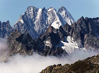
The Lauteraarhorn is a peak of the Bernese Alps, located in the canton of Bern. Together with the higher Schreckhorn, to which it is connected by a high ridge, it lies between the valleys of the Lower Grindelwald Glacier and the Unteraar Glacier, about 10 kilometres southeast of Grindelwald, the closest locality. The Lauteraarhorn belongs to the Aaremassif and is surrounded by large glaciers: the Lauteraargletscher and the Strahlegg-Gletscher and the Obers Ischmeer. Being off the main ridge of the Bernese Alps, all the glaciers surrounding the Lauteraarhorn and the Schreckhorn are part of the Aare basin. The Lauteraarhorn is the second highest summit lying wholly within the canton of Bern. Administratively, it is split between the municipalities of Grindelwald and Guttannen.

The Unteraargletscher, literally "Lower Aare-Glacier", is the larger of the two sources of the Aare river in the Bernese Alps. It emerges from the association of the Finsteraargletscher and the Lauteraargletscher and flows for about 6 km (3.7 mi) to the east down to the Grimselsee near the Grimsel Pass. In total the glacier was 12.95 km (8.05 mi) long and 29.48 km2 (11.38 sq mi) in area in 1973. Its lower end is almost 400 metres lower than that of the neighbouring Oberaargletscher.

The Stein Glacier is a 4 km long glacier (2005) situated at the Susten Pass in the Urner Alps in the easternmost part of the canton of Bern in Switzerland.In 1973 it had an area of 6.06 km2.

The Oberaargletscher, literally "Upper Aare-Glacier", is a 4 km (2.5 mi) long glacier (2005) situated in the Bernese Alps in the canton of Bern in Switzerland. In 1973 it had an area of 5.82 km2 (2.25 sq mi). The lower end of this glacier lies almost 400 m higher than the (original) lower end of neighbouring Unteraargletscher.

The Konkordia Hut is a mountain hut of the Swiss Alpine Club, located north of Fieschertal in the canton of Valais. The hut lies above Konkordiaplatz, the point of convergence of several glaciers in the great Aletsch Glacier system of the Bernese Alps. It is located at a height of 2,850 metres above sea level, at the foot of the Fülbärg.

The Mönchsjoch Hut is a mountain hut located in the Bernese Alps in the canton of Valais in Switzerland. At an altitude of 3,658 metres (12,001 ft) it is the highest staffed hut in Switzerland.

The Finsteraarhorn Hut is a mountain hut of the Swiss Alpine Club, located north of Fieschertal in the canton of Valais. It lies at a height of 3,048 metres (10,000 ft) above sea level at the southern foot of the Finsteraarhorn, the highest peak of the Bernese Alps. The hut overlooks the upper basin of the Fiescher Glacier, which is among the largest of the range. It is located a few kilometres east of the Grünhornlücke.
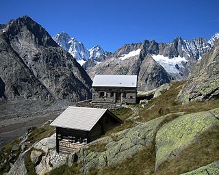
The Lauteraar Hut is a mountain hut of the Swiss Alpine Club, located south-west of Handegg in the canton of Bern. The hut lies at a height of 2,392 metres (7,848 ft) above sea level, above the Unteraar Glacier, at the foot of the Hienderstock in the Bernese Alps.

The Schreckhorn Hut is a mountain hut of the Swiss Alpine Club, located south of Grindelwald in the canton of Bern. The hut lies at a height of 2,529 metres above sea level, above the Lower Grindelwald Glacier, at the foot of the Schreckhorn in the Bernese Alps.

Belpberg is an isolated ridge in the Aaretal between Bern and Thun in Switzerland. The ridge has a width of 2 to 4 km and a length of about 11 km, reaches its highest point on the Chutzen at 892.5 m above sea level and rises up to 370 meters from the surrounding valley plains. Belpberg is bordered on the west by the Gürbetal, on the east by the wide Aaretal and on the north by the Belpmoos, the place where the Gürbetal merges with Aaretal. The southern boundary is formed by a valley furrow near Seftigen. Until 2011, it was in the municipality of Belpberg, which later was merged with Belp.