
Nain County is a county in Isfahan Province in Iran. The capital of the county is Nain. At the 2006 census, the county's population was 54,298, in 15,919 families; excluding those portions, the population was 36,810 in 10,995 families. The county is subdivided into two districts: the Central District and Anarak District. The county has three cities: Nain, Anarak & Bafran.
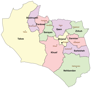
Darmian County is a county in South Khorasan Province in Iran. The capital of the county is Asadiyeh. It was separated from Birjand County in 2005. At the 2006 census, the county's population was 51,793, in 12,893 families. The county consists of three districts Central District, Qohestan District, and Gazik District. The county has four cities: Asadiyeh, Gazik, Qohestan and Tabas-e Masina

Gotvand County is a county in Khuzestan Province in Iran. The capital of the county is Gotvand. It was separated from Shushtar County in 2005. At the 2006 census, the county's population was 58,311, in 11,440 families. The county is subdivided into two districts: the Central District and Aghili District. The county has five cities: Gotvand, Saleh Shahr, Somaleh, Torkalaki & Jannat Makan.
Shahin Shahr and Meymeh County is a county in Isfahan Province in Iran. The capital of the county is Shahin Shahr. At the 2006 census, the county's population was 182,394, in 49,364 families. The county is subdivided into two districts: the Central District and Meymeh District. The county has six cities: Shahin Shahr, Meymeh, Vazvan, Gaz, Gorgab & Lay Bid.
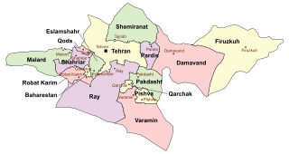
Qods County is a county in Tehran Province in Iran. The capital of the county is Qods. At the 2006 census, the county's population was 237,077, in 62,355 families. The county has one district: the Central District. The county has one city: Qods.
Khanmirza District is a district (bakhsh) in Lordegan County, Chaharmahal and Bakhtiari Province, Iran. At the 2006 census, its population was 31,320, in 6,391 families. The District has one city: Aluni. The District has two rural districts (dehestan): Javanmardi Rural District and Khanmirza Rural District.
Rahimabad District is a district (bakhsh) in Rudsar County, Gilan Province, Iran. The sole city in Rahimabad District, also called Rahimabad, is located west of the Caspian Sea at 35° 22' 54" North, 45° 7' 28" East, and lies at an altitude of 4,268 feet according to Maplandia.com. At the 2006 census, its population was 27,653, in 7,820 families. The District has one city: Rahimabad. The District has four rural districts (dehestan): Eshkevar-e Sofla Rural District, Rahimabad Rural District, Shuil Rural District, and Siyarastaq Yeylaq Rural District.
Kardef is a village in Chelo Rural District, Chelo District, Andika County, Khuzestan Province, Iran. At the 2006 census, its population was 304, in 40 families.

Ashmizan is a village in Kamazan-e Sofla Rural District, Zand District, Malayer County, Hamadan Province, Iran. At the 2006 census, its population was 133, in 32 families.
Gangarestan is a village in Doab Rural District, Bazoft District, Kuhrang County, Chaharmahal and Bakhtiari Province, Iran. At the 2006 census, its population was 51, in 10 families.
Dehaj Rural District is a rural district (dehestan) in Dehaj District, Shahr-e Babak County, Kerman Province, Iran. At the 2006 census, its population was 3,137, in 633 families. The rural district has 29 villages.
Chal Anjir is a village in Sepidar Rural District, in the Central District of Boyer-Ahmad County, Kohgiluyeh and Boyer-Ahmad Province, Iran. At the 2006 census, its existence was noted, but its population was not reported.
Tighiyeh is a village in Vilkij-e Jonubi Rural District, Vilkij District, Namin County, Ardabil Province, Iran. At the 2006 census, its population was 215, in 44 families.
Shahrak-e Gharbi is a village in Qeshlaq-e Shomali Rural District, in the Central District of Parsabad County, Ardabil Province, Iran. At the 2006 census, its population was 1,425, in 384 families.
Toska is a village in Khvosh Rud Rural District, Bandpey-ye Gharbi District, Babol County, Mazandaran Province, Iran. At the 2006 census, its population was 491, in 113 families.
Kalak is a village in Miandorud-e Kuchak Rural District, in the Central District of Sari County, Mazandaran Province, Iran. At the 2006 census, its population was 58, in 18 families.
Gandab is a village in Chahardangeh Rural District, Chahardangeh District, Sari County, Mazandaran Province, Iran. At the 2006 census, its population was 96, in 32 families.
Kuh-e Estel is a village in Rastupey Rural District, in the Central District of Savadkuh County, Mazandaran Province, Iran. At the 2006 census, its population was 133, in 40 families.
Defense Industry Complex, Isfahan is a village and company town in Ashiyan Rural District, in the Central District of Lenjan County, Isfahan Province, Iran. At the 2006 census, its population was 2,444, in 642 families.
Melk Melk is a village in Jolgah Rural District, in the Central District of Jahrom County, Fars Province, Iran. At the 2006 census, its existence was noted, but its population was not reported.

