
The River Don is a river in South Yorkshire and the East Riding of Yorkshire, England. It rises in the Pennines, west of Dunford Bridge, and flows for 69 miles (111 km) eastwards, through the Don Valley, via Penistone, Sheffield, Rotherham, Mexborough, Conisbrough, Doncaster and Stainforth. It originally joined the Trent, but was re-engineered by Cornelius Vermuyden as the Dutch River in the 1620s, and now joins the River Ouse at Goole. Don Valley is a UK parliamentary constituency near the Doncaster stretch of the river.

The River Sheaf in Sheffield, South Yorkshire, England, flows northwards, past Dore, through Abbeydale and north of Heeley. It then passes into a culvert, through which it flows under the centre of Sheffield before joining the River Don. This lower section of the River Sheaf, together with the River Don between the Blonk Street and Lady's Bridges, formed two sides of the boundary of Sheffield Castle.
The Porter Brook is a river which flows through the City of Sheffield, England, descending over 1,000 feet (300 m) from its source on Burbage Moor to the west of the city to its mouth where it joins the River Sheaf in a culvert beneath Sheffield railway station. Like the other rivers in Sheffield, its steep gradient made it ideal for powering water mills and works associated with the metalworking and cutlery industries, and around 20 dams were constructed over the centuries to facilitate this. At its lower end, it is extensively culverted, but parts of it are gradually being restored to open channels, as part of a daylighting scheme for the city.

Ecclesall Ward—which includes the neighbourhoods of Bents Green, Ecclesall, Greystones, Millhouses, and Ringinglow—is one of the 28 electoral wards in City of Sheffield, England. It is located in the southwestern part of the city and covers an area of 3.6 square miles. The population of this ward in 2007 was 19,211 people in 7,626 households, reducing to 6,657 at the 2011 Census. Ecclesall ward is one of the four wards that make up the South West Community Assembly and one of five wards that make up the Sheffield Hallam Parliamentary constituency. The Member of Parliament is Olivia Blake, a Labour MP. Ecclesall is one of the least socially deprived wards in the entire country, with a 2002 deprivation score of 4.7—making it the 8,105th most deprived ward out of 8,414 wards in the country. The demographic consists largely of white, middle-class families.

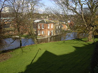
The Kelham Island Museum is an industrial museum on Alma Street, alongside the River Don, in the centre of Sheffield, England. It was opened in 1982.

The Moss is a brook in North East Derbyshire, England.
Totley is a suburb on the extreme southwest of the City of Sheffield, in South Yorkshire, England. Lying in the historic county boundaries of Derbyshire, Totley was amalgamated into the city of Sheffield in 1933, and is today part of the Dore and Totley electoral ward in the city, though it remains close to the contemporary county boundary of Derbyshire. Totley had a population of 7,963 in 2011. Totley was shown at the 2011 census as being part of the ward of Dore and Totley.
Meersbrook is a suburban district in the south-west of Sheffield, England bordered by Nether Edge to the west, Norton Lees to the south, Heeley to the north and the Meersbrook allotment site to the east. Until 1950 it was part of the Sheffield Ecclesall constituency and now forms part of the Sheffield Heeley constituency. The district falls within the Gleadless Valley ward of the city. The name comes from the stream, the Meers Brook, a tributary of the River Sheaf which means 'boundary brook' and in ancient times this, along with the River Sheaf formed the boundary between the Anglo-Saxon kingdoms of Northumbria and Mercia. It remained as the boundary between Yorkshire and Derbyshire into the 20th century. Meersbrook itself was once several small communities which have given many roads their names; Rush Dale, Carfield & Cliffe Field and in 1857 was known as Mears Brook.
Millhouses is a neighbourhood in the City of Sheffield, England. It is located in Ecclesall ward; in the south-western portion of the city on the northwest bank of the River Sheaf. Its origins lie in a small hamlet that grew around the Ecclesall Corn Mill. It has a population of 4,424.

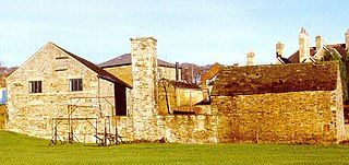
Shepherd Wheel is a working museum in a former water-powered grinding workshop situated on the Porter Brook in the south-west of the City of Sheffield, England. One of the earliest wheels on the River Porter, it is one of the few remaining—and effectively complete—examples of this kind of enterprise, one that used to be commonplace in the Sheffield area. Its 5.5 m (18 ft) diameter overshot water wheel is powered from a large dam stocked with water diverted from the Porter Brook. The workshops, dam, goit and weir are Grade II listed, and the site is a Scheduled Ancient Monument.

Whirlow is a suburb of the City of Sheffield in England, it lies 3.7 miles (6 km) south-west of the city centre. The suburb falls within the Dore and Totley ward of the City. It is one of the most affluent areas of Sheffield, with much high class housing and several notable small country houses within it. During the Victorian era it was home to some of Sheffield's most influential citizens. Whirlow straddles the A625, the main Sheffield to Hathersage road. The suburb covers the area from Parkhead in the north to Whirlow Bridge in the south and from Ecclesall Woods in the east to Broad Elms Lane in the west. Whirlow had a population of 1,663 in 2011.

Abbeydale is an area in the City of Sheffield, England that follows the valley of the River Sheaf. It covers many districts of Sheffield in the south-west of the city running roughly from Heeley Bridge in the district of Heeley to Dore Road between Beauchief and Totley. It is named for the Abbey that existed at Beauchief from the 12th century to 1537.
The Sheffield Industrial Museums Trust (SIMT) is an independent charitable trust based in Sheffield, England, that runs the Sheffield City Council-owned Kelham Island, Abbeydale Industrial Hamlet, and Shepherd Wheel museums.
A blade mill was a variety of water mill used for sharpening newly fabricated blades, including scythes, swords, sickles, and knives.

The Old Hay Brook is a small river in Sheffield, South Yorkshire, England. It is formed from the Redcar Brook, Blacka Dike and another stream, which rise on moors to the south of Sheffield, and is joined by Needham's Dyke near Totley Grange. At Totley Rise it joins Totley Brook, to become the River Sheaf. Water from the river was used to power mills processing lead, corn and paper from at least the 17th century, which were later used for grinding scythes as the Sheffield metal industry expanded. All the mills were defunct by 1900, although some remnants including weirs and dams are still visible.

The Limb Brook is a stream in Sheffield, South Yorkshire, England. It rises at the village of Ringinglow, flowing east through Whirlow and Ecclesall Woods into Abbeydale in the Beauchief area, where it merges with the River Sheaf. Near this point part of the stream has been diverted to provide the goit for the Abbeydale Industrial Hamlet millpond, and this channel flows through what is now Beauchief Gardens.

Butchers Wheel or Butcher Works is a former cutlery and tool factory in Sheffield, South Yorkshire. The last of the manufacturing tenants left in 2004. The building is a listed historic site, and is now used for residential and retail purposes.

35 Well Meadow Street is the site of a house, attached workshops, courtyard complex and a crucible furnace. It is located in the St Vincent's Quarter of the City of Sheffield in England, it is also part of the Well Meadow Conservation Area. The buildings and furnace are grade II* listed buildings because of their importance as part of Sheffield’s industrial heritage and it is regarded as, “One of the most significant of the city’s 19th century industrial monuments”. It has now been converted into residences.

The Darnall Works is a former steelworks in the Darnall area of Sheffield in England. The only remaining large complex of crucible furnaces, the works opened in the 1835 and were frequently extended and adapted until the late 20th century. Some of the structures at the works are listed buildings, at Grade II* and Grade II, and part of the site is a Scheduled Ancient Monument.


