Related Research Articles
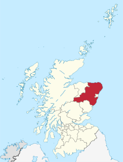
Aberdeenshire is one of the 32 council areas of Scotland.

The River Dee is a river in Aberdeenshire, Scotland. It rises in the Cairngorms and flows through southern Aberdeenshire to reach the North Sea at Aberdeen. The area it passes through is known as Deeside, or Royal Deeside in the region between Braemar and Banchory because Queen Victoria came for a visit there in 1848 and greatly enjoyed her visit. She and her husband, Prince Albert, replaced an old castle there and built Balmoral Castle.
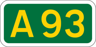
The A93 is a major road in Scotland and the highest public road in the United Kingdom. It runs north from Perth through Blairgowrie and Rattray, then through the Grampian Mountains by way of Glenshee, the Cairnwell Pass and Glen Clunie to Braemar in Aberdeenshire. At Braemar, the road then switches east down the strath of the River Dee before crossing the A90 and terminating in Aberdeen.

Aberdeenshire or the County of Aberdeen is a historic county and registration county of Scotland. The area of the county, excluding the city of Aberdeen itself, is also a lieutenancy area. The county borders Kincardineshire, Angus and Perthshire to the south, Inverness-shire and Banffshire to the west, and the North Sea to the north and east. It has a coast-line of 65 miles (105 km).

Kincardine and Mearns is one of six area committees of the Aberdeenshire council area in Scotland. It has a population of 38,506. There are significant natural features in this district including rivers, forests, mountains and bogs.

Fetternear Bishop's Palace is an archaeological site of what was one of the palaces of the medieval bishops of Aberdeen. it is near Kemnay in Aberdeenshire. Later, a ruined tower-house and mansion of Fetternear House were built on part of the site.
John Smith was a Scottish architect. His career started in 1805 and he was appointed as the official city architect of Aberdeen in 1807, the first person to hold this post. Together with Archibald Simpson, he contributed significantly to the architecture of Aberdeen, and many of the granite buildings that gave the city the nickname 'The Granite City' or also 'The Silver City' are attributed to them.

The Castle of Rattray was a medieval Scottish castle, with multiple variations on its structure over approximately six centuries. Originally built as a "late 12th- or early 13th century defensive motte" it provided protection for Starny Keppie Harbour and Rattray village. Sometime between 1214 and 1233 it was upgraded by William Comyn, jure uxoris Earl of Buchan before being destroyed in the 1308 Harrying of Buchan. After Comyn's timber castle was burned down, it was replaced by a stronger stone castle which was engulfed during a 1720 sand storm along with nearby Rattray village. After the storm, the castle was not dug out and remains covered to this day. The castle was described by W. Douglas Simpson as one of the nine castles of the Knuckle, referring to the rocky headland of north-east Aberdeenshire.

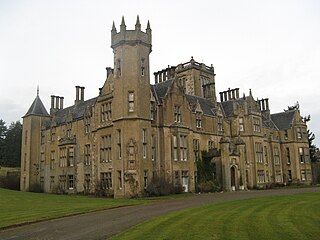
Dunecht House is a stately home on the Dunecht estate in Aberdeenshire, Scotland. The house is protected as a category A listed building, and the grounds are included on the Inventory of Gardens and Designed Landscapes in Scotland, the national listing of significant gardens.

Cairnbulg Castle is a z-plan castle situated in Cairnbulg, Aberdeenshire, Scotland. It was described by W. Douglas Simpson as one of the nine castles of the Knuckle, referring to the rocky headland of north-east Aberdeenshire. It stands by the River Philorth and was originally known as Philorth Castle. The 17th-century Philorth Castle, an L-plan house consisting of a sizeable crow-stepped block, was demolished after a fire in 1915.
Dundarg Castle is a ruined castle about 2 kilometres (1.2 mi) north-northeast of New Aberdour, Aberdeenshire, Scotland, built within the ramparts of an earlier Iron Age promontory fort. It was described by W. Douglas Simpson as one of the nine castles of the Knuckle, referring to the rocky headland of north-east Aberdeenshire, and by Charles McKean as "Scotland's answer to Tintagel". It became a small Celtic monastery for a period.

Kincardine Castle is a Victorian country house in Royal Deeside, Scotland. Formerly known as Kincardine House, it is a private home which also operates as a hospitality venue. The house sits 1 kilometre (0.62 mi) north-east of the village of Kincardine O'Neil, and 8 kilometres (5.0 mi) east of Aboyne on the north side of the River Dee, Aberdeenshire.

Castle Forbes is a 19th-century country house in the Scottish baronial architecture style near Alford in Aberdeenshire, Scotland.

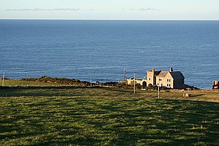
Abergeldie Castle is a four-floor tower house in Crathie and Braemar parish, SW Aberdeenshire, Scotland. It stands at an altitude of 840 feet (260 m), on the south bank of the River Dee, five miles (8 km) west of Ballater, and about two miles (3 km) east of the royal residence of Balmoral Castle. Behind it rises Creag nam Ban, a rounded granite hill about 527 metres (1,729 ft) high, and across the river to its front is the cairn-crowned Geallaig Hill, rising to 743 metres (2,438 ft).

Cluny Castle was originally built c.1604 as a Z-plan castle replacing either a house or small peel tower. Sited in the parish of Cluny, it is south of Monymusk and north of Sauchen in Aberdeenshire, north-east Scotland. Owned by three separate branches of Gordon families over the centuries, it was used to shelter Jacobite rebels in the mid-18th century. Extensive additions were made in 1820 to the design of architect John Smith when it was in the ownership of Colonel John Gordon. Two wings of the castle and the adjoining private chapel were destroyed by fire in 1926, but the damage was restored.
Fordyce Castle is a T-plan castle, its oldest part dating from 1592, about three miles south-west of Portsoy, in the village of Fordyce, Aberdeenshire, Scotland.
Dumbreck Castle was a tower house, dating from the 16th century, around 3.5 miles (5.6 km) west of Ellon, in Aberdeenshire, Scotland.
The Findhorn Viaduct is a railway bridge near Forres in Moray, Scotland. Built for the Inverness & Aberdeen Junction Railway between 1856 and 1858 by Joseph Mitchell, with ironwork by William Fairbairn & Sons of Manchester, the viaduct carries the railway line over the River Findhorn approximately 1.7 km west of the town of Forres.

Glenkindie Castle was a 16th-century castle, about 3 miles (4.8 km) south-west of Kildrummy, Aberdeenshire, Scotland, at Glenkindie, north of the River Don, 0.5 miles (0.80 km) east of the confluence with the Kindie Burn.
Gairn Water, situated in the Cairngorms National Park, is a river with an elevation of 899 feet and a length of 4.75 kilometres.
References
- 1 2 3 Coventry Martin (1997) The Castles of Scotland. Goblinshead. ISBN 1 899874 10 0 p48
- ↑ "Abergairn Castle". The Antiquaries Journal. Retrieved 28 July 2014.
- ↑ "Abergairn Castle". Gazetteer for Scotland. Retrieved 28 July 2014.
- 1 2 3 "Abergairn Castle". Canmore. Retrieved 28 July 2014.
- ↑ Macdonald, James (1900). Place Names Of West Aberdeenshire. Aberdeen: University of Aberdeen. p. 32 . Retrieved 2 April 2019.