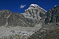
Abi (Cholo)

Last updated

Abi
Cholo
Cholo 6043m.jpg
Southwest aspect
Highest point
Elevation 6,043 m (19,826 ft) [1] [2]
Prominence 423 m (1,388 ft) [3]
Isolation 1.62 km (1.01 mi) [3]
Listing Mountains of Nepal
Coordinates 27°59′01″N86°43′14″E / 27.983689°N 86.720671°E / 27.983689; 86.720671 [3]
Geography
Nepal rel location map.svg
Red triangle with thick white border.svg
Abi
Location in Nepal
Abi (Cholo)
Interactive map of Abi
Location Khumbu
Country Nepal
Province Koshi
District Solukhumbu
Protected area Sagarmatha National Park
Parent range Himalayas

Abi, also known as Cholo, or Kangchung, is a mountain in Nepal.

Contents

Description

Abi is a 6,043-metre (19,826-foot) summit in the Khumbu region of the Nepalese Himalayas. It is situated 20 kilometres (12 mi) west of Mount Everest and four kilometres (2.5 mi) northeast of Gokyo in Sagarmatha National Park. Topographic relief is significant as the summit rises 900 metres (2,953 ft) above the Gaunara Glacier in 0.6 kilometre (0.37 mi). Precipitation runoff from the mountain's slopes drains into the Dudh Koshi. [3] Trekkers pass by this peak en route to Everest Base Camp. This peak is a popular climbing destination and is on the list of permitted trekking peaks. [4] [5]

Climate

Based on the Köppen climate classification, Abi is located in a tundra climate zone with cold, snowy winters, and cool summers. [6] Weather systems coming off the Bay of Bengal are forced upwards by the Himalaya mountains (orographic lift), causing heavy precipitation in the form of rainfall and snowfall. Mid-June through early-August is the monsoon season. The months of April, May, September, and October offer the most favorable weather for viewing or climbing this peak. [7]

See also

References

  1. "Abi". Nepal Himal Peak Profile. Government of Nepal. Retrieved 21 April 2025.
  2. "Cholo". Peakvisor.com. Retrieved 21 April 2025.
  3. 1 2 3 4 "Abi, Nepal". Peakbagger.com. Retrieved 21 April 2025.
  4. Trekking peaks of Nepal, project-himalaya.com, Retrieved April 21, 2025.
  5. Nepal "Trekking Peaks", Peakbagger, Retrieved April 21, 2025.
  6. Peel, M. C.; Finlayson, B. L.; McMahon, T. A. (2007). "Updated world map of the Köppen−Geiger climate classification". Hydrol. Earth Syst. Sci. 11. ISSN   1027-5606.
  7. Everest Treks: A Month By Month Review of the Best Seasons, Brinley Clark, Himalayanwonders.com, Retrieved April 21, 2025.