
Sudan, officially the Republic of the Sudan, is a country in eastern Africa. It is bordered by Egypt to the north, Libya to the northwest, Chad to the west, the Central African Republic to the southwest, South Sudan to the south, Ethiopia to the southeast, Eritrea to the east, and the Red Sea to the northeast. Sudan has a population of 43 million and occupies 1,886,068 square kilometres, making it Africa's third-largest country and also the third-largest in the Arab world. Before South Sudan's secession from Sudan on 9 July 2011, the united Sudan was the largest country in Africa and the Arab world by area. Sudan's predominant religion is Islam, and its official languages are Arabic and English. The capital is Khartoum, located at the confluence of the Blue and White Nile. Since 2011, Sudan has been the scene of an ongoing military conflict in its southern states.

The White Nile is a river in Africa, one of the two main tributaries of the Nile; the other is the Blue Nile. The name comes from colouring due to clay carried in the water.
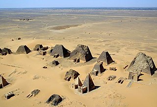
Nubian pyramids are pyramids that were built by the rulers of the ancient Kushite kingdoms. The area of the Nile valley known as Nubia, which lies within the north of present day Sudan, was home to three Kushite kingdoms during antiquity. The first had its capital at Kerma. The second was centered on Napata. Finally, the last kingdom was centered on Meroë. They are built of granite and sandstone. The pyramids were partially demolished by Italian treasure hunter Giuseppe Ferlini in the 1830s.

Makuria was a Nubian kingdom located in what is today Northern Sudan and Southern Egypt. Makuria originally covered the area along the Nile River from the Third Cataract to somewhere south of Abu Hamad as well as parts of northern Kordofan. Its capital was Dongola, and the kingdom is sometimes known by the name of its capital.

Alodia, also known as Alwa, was a medieval Nubian kingdom in what is now central and southern Sudan. Its capital was the city of Soba, located near modern-day Khartoum at the confluence of the Blue and White Nile rivers.

The Kerma culture or Kerma kingdom was an early civilization centered in Kerma, Sudan. It flourished from around 2500 BCE to 1500 BCE in ancient Nubia. The Kerma culture was based in the southern part of Nubia, or "Upper Nubia", and later extended its reach northward into Lower Nubia and the border of Egypt. The polity seems to have been one of a number of Nile Valley states during the Middle Kingdom of Egypt. In the Kingdom of Kerma's latest phase, lasting from about 1700–1500 BCE, it absorbed the Sudanese kingdom of Sai and became a sizable, populous empire rivaling Egypt. Around 1500 BCE, it was absorbed into the New Kingdom of Egypt, but rebellions continued for centuries. By the eleventh century BCE, the more-Egyptianized Kingdom of Kush emerged, possibly from Kerma, and regained the region's independence from Egypt.
Soba is the former capital of the medieval Nubian kingdom of Alodia from the sixth century until around 1500. E. A. Wallis Budge identified it with a group of ruins on the Blue Nile 19 kilometres (12 mi) from Khartoum, where there are remains of a Meroitic temple that had been converted into a Christian church. This would place Soba in the modern-day Sudanese state of Al Jazirah.

The region of Semna is 15 miles south of Wadi Halfa and is situated where rocks cross the Nile narrowing its flow—the Semna Cataract.

El Kab is an Upper Egyptian site on the east bank of the Nile at the mouth of the Wadi Hillal about 80 kilometres (50 mi) south of Luxor. El Kab was called Nekheb in the Egyptian language, a name that refers to Nekhbet, the goddess depicted as a white vulture. In Greek it was called Eileithyias polis, "city of the goddess Eileithyia".
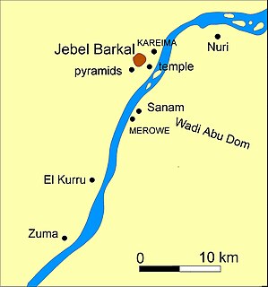
Nuri is a place in modern Sudan on the west side of the Nile, near the Fourth Cataract. Nuri is situated about 15 km north of Sanam, and 10 km from Jebel Barkal.
El-Hobagi is an archaeological site in Sudan. It lies approximately 65 kilometres (40 mi) southwest of Meroe on the western side of the Nile, near the sixth cataract. A number of large tumuli were found at el-Hobagi from the period after the fall of the Meroitic kingdom, but before the Christianization of Nubia. The site, which is dated to the 4th century, is situated near a post-Meroitic cemetery. Grave mounds excavated by a French team revealed an absence of rich gifts, instead containing weapons such as swords, spears, axes, arrows and bows. The dead lay on a bed and were surrounded by numerous vessels. There was also a bronze bowl, which contains one of the last known Meroitic inscriptions; it is decorated with agricultural scenes and the word Qore ("King"). This suggests that local kings were buried here in the wake of the Meroitic kingdom. Some findings suggest that the King's court was moved to the area of el-Hobagi in the 4th century AD, though no village of that era has been found here. Tumulus III at El Hobagi is believed to date to the early Postmeroitic period of the late 4th century.

Meinarti was an island with a Nubian village in northern Sudan. Situated in the Nile, Meinarti was just north of the 2nd Cataract, a few kilometers upstream of the Sudanese border town of Wadi Halfa. On the island was an artificial mount 175m long and 12.5m high, consisting of stratified archaeological remains. When excavated it proved to contain 18 recognizable levels, the result of six separate and distinct phases of occupation. Each phase was followed by a period of abandonment and then a complete rebuilding. Structural remains at all phases were entirely of mud brick. Meinarti was excavated by William Yewdale Adams from 1962 to 1964, prior to perishing in the 1960s with the rising of Lake Nubia due to the Aswan Dam.

The Daju kingdom was a medieval monarchy that existed in Darfur (Sudan) from possibly the 12th–15th century. Its name stems from the Daju people, the ruling ethnic group. The Daju were eventually ousted from power by the Tunjur and the last Daju king subsequently fled to present-day Chad. The sources for the Daju kingdom are almost entirely local traditions collected in the 19th and 20th century and mentions by medieval Arab historians.

The kingdom of Fazughli was a precolonial state in what is now southeastern Sudan and western Ethiopia. Oral traditions assert its establishment to refugees from the Nubian kingdom of Alodia, after its capital Soba had fallen to Arabs or the Funj in c. 1500. Centered around the mountainous region of Fazughli on the Blue Nile and serving as a buffer between the Funj sultanate and the Ethiopian empire, the kingdom lasted until its incorporation into the Funj sultanate in 1685.

The kingdom of al-Abwab was a medieval Nubian monarchy in what is now central Sudan. Initially the most northerly province of Alodia, it appeared as an independent kingdom from 1276. Henceforth it was repeatedly recorded by Arabic sources in relation to the wars between its northern neighbour Makuria and the Egyptian Mamluk sultanate, where it generally sided with the latter. In 1367 it is mentioned for the last time, but based on pottery finds it has been suggested that the kingdom continued to exist until the 15th, perhaps even the 16th, century. During the reign of Funj king Amara Dunqas the region is known to have become part of the Funj sultanate.

The Dongola Reach is a reach of approximately 160 km in length stretching from the Fourth downriver to the Third Cataracts of the Nile in Upper Nubia, Sudan. Named after the Sudanese town of Dongola which dominates this part of the river, the reach was the heart of ancient Nubia.

Selima Oasis is an oasis in the Sudan located 90 kilometres (56 mi) west of the Third Cataract of the Nile and the ancient site of Amara West. It lies along the Darb al-Arbaʿīn, a desert track linking Kordofan with Egypt. Just to the north of Selima, the track splits into a northern route going to Kharga Oasis and a northwestern route going to Dunqul Oasis.

The Hosh el-Kab fort is a fort in Sudan. Ruins of a stone fort located on the left bank of the Nile, in Khartoum State (Sudan), at a distance of 40 km from the place where the waters of the White Nile meet with the Blue Nile. The enclosure was erected in the 2nd half of the 6th century AD. At that time, the region was under the Alwan rule.
The Sudan Archaeological Research Society is a registered British charity based in London, UK. It was founded in 1991 to study the history and culture of Sudan and expanded its remit in 2011 to include the newly independent South Sudan. The society has surveyed and excavated numerous archaeological sites across Sudan, and disseminates its research through publications and events.
