U.S. Route 19 (US 19) is a north–south U.S. Highway. Despite encroaching Interstate Highways, the route has remained a long-haul route, connecting the Gulf of Mexico with Lake Erie.
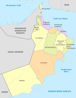
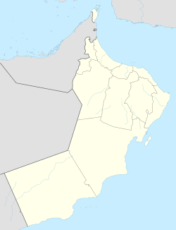
Oman is divided into eleven governorates (muhafazah), and has been since 28 October 2011. Each of the 11 governorates are divided into provinces (wilayat).
The Polk Parkway, also known as Florida State Road 570, is a 24-mile (39 km), limited-access toll road which runs through Polk County, Florida. It is operated as part of the Florida's Turnpike Enterprise system of limited-access expressways. The Polk Parkway mainly serves as a beltway around Lakeland forming a semicircle, which along with I-4 circumscribes most of the city limits of Lakeland.
State Road 909 is a 3.77-mile-long (6.07 km) state highway in northern Miami-Dade County, Florida, United States. It runs along West Dixie Highway, the original alignment of the Dixie Highway, from the east end of Gratigny Drive in North Miami northeast to North Miami Beach Boulevard in North Miami Beach, just across the Florida East Coast Railway from Biscayne Boulevard. State Road 909 is actually in two pieces as motorists traveling the route in North Miami encounter signs on North Miami Boulevard saying "TO 909" and "To W Dixie Hwy" and guiding them along a two-block "detour" to the other section.
State Road 989, locally known as Allapattah Road and Southwest 112th Avenue, is a 3.0-mile-long (4.8 km) north–south four lane undivided highway in southern Miami-Dade County, Florida between the Homestead Air Reserve Base and Cutler Bay. SR 989 begins at an interchange with the Homestead Extension of Florida's Turnpike and ends at an intersection with the Dixie Highway.

Alberta Provincial Highway No. 21, commonly referred to as Highway 21, is a north-south highway in Alberta, Canada that parallels Highway 2 between Calgary and Edmonton. It is approximately 328 kilometres (204 mi) in length. It begins at the Trans-Canada Highway (Highway 1) east of Strathmore, and ends at Fort Saskatchewan where it is succeeded by Highway 15. The northernmost 25 kilometres (16 mi) of the highway are twinned. Highway 21 runs roughly parallel to the main north-south CN rail line between Calgary and Edmonton between Three Hills and Looma.

New York State Route 17A (NY 17A) is a state highway in southern New York in the United States, entirely within Orange County. Its western terminus is located in the village of Goshen at a junction with NY 17, and its eastern terminus is at another intersection with NY 17 located in Southfields. It runs concurrently with NY 94 from Warwick to Florida. It serves mainly to connect Warwick with the rest of the county. While it is an east–west route, many sections run in a more north–south orientation. Its circuitous route allows it to offer much scenery to drivers.

Adam is a town in the region Ad Dakhiliyah, in northeastern Oman.
Highway 925 is a provincial highway in the far north region of the Canadian province of Saskatchewan. It begins about ten kilometres south of Buffalo Narrows on Highway 155 and ends in Michel Village. Highway 925 is about 76 km (47 mi) long.
Interstate 25 (I-25) in the U.S. state of New Mexico follows the north–south corridor through Albuquerque and Santa Fe. It replaced U.S. Route 85 (US 85), which is no longer signed, but still exists in route logs sharing the I-25 alignment. I-25 starts in New Mexico at an interchange with I-10 in Las Cruces and extends roughly 460 miles (740 km) before reaching Colorado. I-25 passes through principally rural land through central New Mexico and passes through or near the cities of Las Cruces, Truth or Consequences, Socorro, Belen, Albuquerque, Santa Fe, Las Vegas, and Raton.
ISO 3166-2:OM is the entry for Oman in ISO 3166-2, part of the ISO 3166 standard published by the International Organization for Standardization (ISO), which defines codes for the names of the principal subdivisions of all countries coded in ISO 3166-1.
Coral Reef Drive, also known as South 152nd Street, is a 9.6-mile-long (15.4 km) main east–west road south south of Miami in Miami-Dade County, Florida, United States. It serves to connect the communities of Country Walk and Richmond Heights with Palmetto Bay. State Road 992 is designated along the 2.462-mile-long (3.962 km) section of Coral Reef Drive between the Homestead Extension of Florida's Turnpike and US 1.
Al Akhdar is a village in Ad Dhahirah Region, in northeastern Oman. It lies just to the northwest of the regional capital of Ibri along Highway 21. The village contains a post office and has been assigned the postcode 516.
The Kampala–Jinja Highway is a road in Uganda, connecting the cities of Kampala and Jinja. Sometimes referred to as Kampala–Jinja Road, it is a busy road, with several towns, trading centers and other points of interest along the way. As of October 2016, a new, wider, four-lane dual carriageway expressway, the Kampala–Jinja Expressway, is proposed to be constructed south of the present highway to relieve traffic and complement existing transport infrastructure between Kampala and Jinja.

Nakawa is an area in the city of Kampala, Uganda's capital. It is also the location of the headquarters of Nakawa Division, one of the five administrative divisions of Kampala.
As Subaykhi is a village in Ad Dhahirah Region, in northeastern Oman.The village is located just off Highway 21, south of Mazim and about 20 miles northwest of Ibri. Over half of the village is covered in green trees and agricultural land. A hill area to the south of the village is known as Jebel Subaykhi.The central government have discouraged Iqtabi families from moving into As Subaykhi. In the late 1970s, it was reported that semi- nomads were building more permanent structures, adjacent to the village.
Bakhabi is a village in Ad Dhahirah Region, in northeastern Oman.It lies along Highway 21 opposite Abu Silah, north of Mazim.
Al-Qābil is a village in Al Buraimi Governorate, in northeastern Oman. A small agricultural village on the edge of the Wahibah Desert, Al Qabil lies about 25 km (16 mi) south along the Muscat-Sur Highway from Al Ain across the border in the United Arab Emirates. The village lies south of Mazyad and Al-Zahir, west of Hisn Mazyad, and 10 km (6.2 mi) northwest of Al-Mintirib. Described as a "prosperous market village", Al-Qabil lies at a curve in the road before "descending into the Sa'dah basin from the west". The village is said to contain populations of the Al Bu-Shamis group of the Na'im who moved into the village from across the border with the Emirates. Wadi Sarin is said to flow nearby.
Yibal Airport is an airport serving the town of Yibal in the Ad Dhahirah Governorate of Oman.