The Arabian Sea is a region of the northern Indian Ocean bounded on the north by Pakistan and Iran, on the west by the Gulf of Aden, Guardafui Channel and the Arabian Peninsula, on the southeast by the Laccadive Sea, on the southwest by the Somali Sea, and on the east by India. Its total area is 3,862,000 km2 (1,491,000 sq mi) and its maximum depth is 4,652 metres (15,262 ft). The Gulf of Aden in the west connects the Arabian Sea to the Red Sea through the strait of Bab-el-Mandeb, and the Gulf of Oman is in the northwest, connecting it to the Persian Gulf.

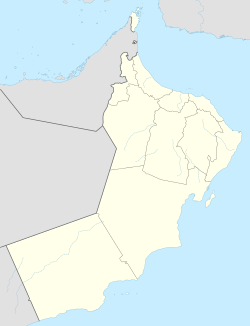
Oman is a country situated in Southwest Asia, bordering the Arabian Sea, Gulf of Oman, and Persian Gulf, between Yemen and the United Arab Emirates (UAE).

The Jebel Akhar, is part of Al Hajar Mountains range in Ad Dakhiliyah Governorate of Oman. It extends about 300 km (190 mi) northwest to southeast, between 50–100 mi (80–161 km) inland from the coast of the Gulf of Oman.

The Dhofar Governorate is the largest of the eleven Governorates in the Sultanate of Oman in terms of area. It lies in Southern Oman, on the eastern border with Yemen's Al Mahrah Governorate. It is a rather mountainous area that covers 99,300 km2 (38,300 sq mi) and has a population of 249,729 as of the 2010 census. The largest city, as well as capital of the Governorate, is Salalah. Historically, the region was the chief source of frankincense in the world. The local variety of Arabic is Dhofari Arabic, which is quite distinct from that of the rest of Oman and from Yemen.

Ibri is a city and Wilāyat (Province) in the region Az Zahirah, in northwest Oman.
Al Buraimi is a governorate of Oman which was split from the Ad Dhahirah Region. Until October 2006, the area was part of Ad Dhahirah Region. At this time, the new governorate was created from the Wilayats (Provinces) of Al Buraymi and Mahdah. A third wilayat, As-Sunaynah, was created from parts of the two.
Al Akhdar is a village in Ad Dhahirah Region, in northeastern Oman. It lies just to the northwest of the regional capital of Ibri along Highway 21. The village contains a post office and has been assigned the postcode 516.

Smith is a hamlet in northern Alberta, Canada within the Municipal District of Lesser Slave River No. 124. It is located on Highway 2A, approximately 182 kilometres (113 mi) northwest of Edmonton, at the confluence of the Lesser Slave River and the Athabasca River.
Bakhabi is a village in Ad Dhahirah Region, in northeastern Oman.It lies along Highway 21 opposite Abu Silah, north of Mazim.
Al-Qābil is a village in Al Buraimi Governorate, in northeastern Oman. A small agricultural village on the edge of the Wahibah Desert, Al Qabil lies about 25 km (16 mi) south along the Muscat-Sur Highway from Al Ain across the border in the United Arab Emirates. The village lies south of Mazyad and Al-Zahir, west of Hisn Mazyad, and 10 km (6.2 mi) northwest of Al-Mintirib. Described as a "prosperous market village", Al-Qabil lies at a curve in the road before "descending into the Sa'dah basin from the west". The village is said to contain populations of the Al Bu-Shamis group of the Na'im who moved into the village from across the border with the Emirates. Wadi Sarin is said to flow nearby.
Sunaynah or As Sunaynah is a Wilayah in Al Buraimi Governorate, in northeastern Oman. The village contains a substantial area of greenery and is described "remote, even by Omani standards". The village is reportedly occupied by the Al Nuaimi tribe; in the 1960s the tamimah of the Al Nuaim was reported to be 'Ali ibn Hamuda of the Al Bu Khuraiban division, who lived at Sunainah.
Tanam or Tan`am is a village in Ad Dhahirah Region, in northeastern Oman. The village lies just southwest of the town of Ibri in Wadi Aswad. The village is described as "little more than an oasis surrounded by block house"It is an important centre for date production and contains a notable population of Duru peoples, especially since the 1970s, when the gather during the date harvest but then return to their nomadic life." The village contains Tanam Hospital, a 200-bed hospital.The hamlet of Dubayshi lies to the north and the hamlet of Khuldah immediately west.
The Jebel Akhdar War or the Jebel Akhdar rebellion broke out in 1954 and again in 1957 in Oman, as an effort by Imam Ghalib Alhinai to protect the Imamate of Oman lands from the advancement plans of Sultan Said bin Taimur, backed by the British government. The Imamate was eventually supported by the Kingdom of Saudi Arabia and Egypt. The war lasted until 1959, when the British armed forces decided to take on direct interventions using air and ground attacks on the Imamate, which won the Sultanate the war.
The 2011 Sultan Qaboos Cup was the 39th edition of the Sultan Qaboos Cup, the premier knockout tournament for football teams in Oman.

Biladhi Shuhoom is a small village near Ibri town in Oman. The village lies near Mokniyath town on the way to Ibri. There is one school and Friday mosque in the village.

John Gordon Lorimer CIE, also known as J. G. Lorimer, was a British diplomat, historian and colonial administrator. Working for the British Raj in Punjab and the Northwest frontier province, he later served in the Persian Gulf region as British Political Resident. He is most famous for his encyclopedia, the Gazetteer of the Persian Gulf, Oman and Central Arabia.
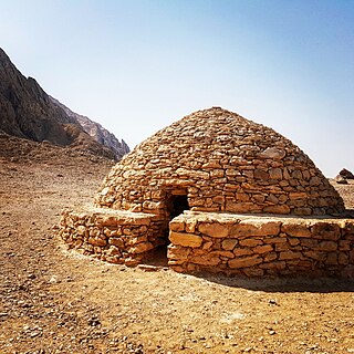
The Hafit period defines early Bronze Age human settlement in the United Arab Emirates and Oman in the period from 3200 to 2600 BC. It is named after the distinctive beehive burials first found on Jebel Hafit, an outlier of Al Hajar Mountains in the region of Tawam, which is composed of the UAE city of Al Ain and the adjacent Omani town of Al-Buraimi, and borders the Rub Al Khali desert. Hafit period tombs and remains have also been located across the UAE and Oman in sites such as Bidaa bint Saud, Jebel Al-Buhais and Buraimi.