Zalipie is a village in Poland, in Gmina Olesno, Dąbrowa County, Lesser Poland Voivodeship. It is approximately 7 kilometres (4 mi) west of Olesno, 13 km (8 mi) north-west of Dąbrowa Tarnowska, and 68 km (42 mi) east of the regional capital Kraków.
Gmina Bolesław is a rural gmina in Dąbrowa County, Lesser Poland Voivodeship, in southern Poland. Its seat is the village of Bolesław, which lies approximately 15 kilometres (9 mi) north-west of Dąbrowa Tarnowska and 73 km (45 mi) east of the regional capital Kraków.
Gmina Gręboszów is a rural gmina in Dąbrowa County, Lesser Poland Voivodeship, in southern Poland. Its seat is the village of Gręboszów, which lies approximately 18 kilometres (11 mi) north-west of Dąbrowa Tarnowska and 64 km (40 mi) east of the regional capital Kraków.
Gmina Mędrzechów is a rural gmina in Dąbrowa County, Lesser Poland Voivodeship, in southern Poland. Its seat is the village of Mędrzechów, which lies approximately 14 kilometres (9 mi) north of Dąbrowa Tarnowska and 76 km (47 mi) east of the regional capital Kraków.

Ćwików is a village in the administrative district of Gmina Olesno, within Dąbrowa County, Lesser Poland Voivodeship, in southern Poland. It lies approximately 4 kilometres (2 mi) north-west of Olesno, 10 km (6 mi) north-west of Dąbrowa Tarnowska, and 72 km (45 mi) east of the regional capital Kraków.
Dąbrówka Gorzycka is a village in the administrative district of Gmina Olesno, within Dąbrowa County, Lesser Poland Voivodeship, in southern Poland.
Dąbrówki Breńskie is a village in the administrative district of Gmina Olesno, within Dąbrowa County, Lesser Poland Voivodeship, in southern Poland. It lies approximately 4 kilometres (2 mi) north of Olesno, 10 km (6 mi) north of Dąbrowa Tarnowska, and 76 km (47 mi) east of the regional capital Kraków.
Niwki is a village in the administrative district of Gmina Olesno, within Dąbrowa County, Lesser Poland Voivodeship, in southern Poland. It lies approximately 6 kilometres (4 mi) west of Olesno, 12 km (7 mi) north-west of Dąbrowa Tarnowska, and 68 km (42 mi) east of the regional capital Kraków.
Oleśnica is a village in the administrative district of Gmina Olesno, within Dąbrowa County, Lesser Poland Voivodeship, in southern Poland. It lies approximately 6 kilometres (4 mi) south of Olesno, 4 km (2 mi) west of Dąbrowa Tarnowska, and 72 km (45 mi) east of the regional capital Kraków.

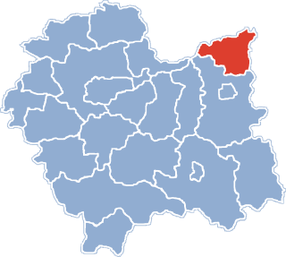
Olesno is a village in Dąbrowa County, Lesser Poland Voivodeship, in southern Poland. It is the seat of the gmina called Gmina Olesno. It lies approximately 7 kilometres (4 mi) north-west of Dąbrowa Tarnowska and 74 km (46 mi) east of the regional capital Kraków.
Pilcza Żelichowska is a village in the administrative district of Gmina Olesno, within Dąbrowa County, Lesser Poland Voivodeship, in southern Poland. It lies approximately 5 kilometres (3 mi) west of Olesno, 10 km (6 mi) north-west of Dąbrowa Tarnowska, and 69 km (43 mi) east of the regional capital Kraków.
Podborze is a village in the administrative district of Gmina Olesno, within Dąbrowa County, Lesser Poland Voivodeship, in southern Poland. It lies approximately 2 kilometres (1 mi) east of Olesno, 7 km (4 mi) north-west of Dąbrowa Tarnowska, and 75 km (47 mi) east of the regional capital Kraków.
Swarzów is a village in the administrative district of Gmina Olesno, within Dąbrowa County, Lesser Poland Voivodeship, in southern Poland. It lies approximately 3 kilometres (2 mi) south-east of Olesno, 5 km (3 mi) north-west of Dąbrowa Tarnowska, and 74 km (46 mi) east of the regional capital Kraków.
Pisarzówka is a village in the administrative district of Gmina Biecz, within Gorlice County, Lesser Poland Voivodeship, in southern Poland. It lies approximately 5 kilometres (3 mi) west of Biecz, 9 km (6 mi) north of Gorlice, and 99 km (62 mi) southeast of the regional capital Kraków.
Żarczyce Małe is a village in the administrative district of Gmina Małogoszcz, within Jędrzejów County, Świętokrzyskie Voivodeship, in south-central Poland. It lies approximately 6 kilometres (4 mi) south-west of Małogoszcz, 19 km (12 mi) north of Jędrzejów, and 32 km (20 mi) west of the regional capital Kielce.
Oleszno is a village in the administrative district of Gmina Krasocin, within Włoszczowa County, Świętokrzyskie Voivodeship, in south-central Poland. It lies approximately 8 kilometres (5 mi) north-west of Krasocin, 12 km (7 mi) north-east of Włoszczowa, and 41 km (25 mi) west of the regional capital Kielce.
Myślina is a village in the administrative district of Gmina Dobrodzień, within Olesno County, Opole Voivodeship, in south-western Poland. It lies approximately 7 kilometres (4 mi) south-west of Dobrodzień, 20 km (12 mi) south of Olesno, and 31 km (19 mi) east of the regional capital Opole.
Bobrowa is a village in the administrative district of Gmina Rudniki, within Olesno County, Opole Voivodeship, in south-western Poland. It lies approximately 7 kilometres (4 mi) south-east of Rudniki, 20 km (12 mi) north-east of Olesno, and 61 km (38 mi) north-east of the regional capital Opole.
Prusków is a village in the administrative district of Gmina Zębowice, within Olesno County, Opole Voivodeship, in south-western Poland. It lies approximately 3 kilometres (2 mi) north of Zębowice, 12 km (7 mi) south-west of Olesno, and 32 km (20 mi) north-east of the regional capital Opole.