Ross Island is an island formed by four volcanoes in the Ross Sea near the continent of Antarctica, off the coast of Victoria Land in McMurdo Sound. Ross Island lies within the boundaries of Ross Dependency, an area of Antarctica claimed by New Zealand.

Stonington Island is a rocky island lying 1.8 km (1.1 mi) northeast of Neny Island in the eastern part of Marguerite Bay off the west coast of Graham Land, Antarctica. It is 0.75 km (0.47 mi) long from north-west to south-east and 0.37 km (0.23 mi) wide, yielding an area of 20 ha. It was formerly connected by a drifted snow slope to Northeast Glacier on the mainland. Highest elevation is Anemometer Hill which rises to 25 m (82 ft).

The Australasian Antarctic Expedition was a 1911–1914 expedition headed by Douglas Mawson that explored the largely uncharted Antarctic coast due south of Australia. Mawson had been inspired to lead his own venture by his experiences on Ernest Shackleton's Nimrod expedition in 1907–1909. During its time in Antarctica, the expedition's sledging parties covered around 4,180 kilometres (2,600 mi) of unexplored territory, while its ship, SY Aurora, navigated 2,900 kilometres (1,800 mi) of unmapped coastline. Scientific activities included meteorological measurements, magnetic observations, an expansive oceanographic program, and the collection of many biological and geological samples, including the discovery of the first meteorite found in Antarctica. The expedition was the first to establish and maintain wireless contact between Antarctica and Australia. Another planned innovation – the use of an aircraft – was thwarted by an accident before the expedition sailed. The plane's fuselage was adapted to form a motorised sledge or "air-tractor", but it proved to be of very limited usefulness.

SY Aurora was a 580-ton barque-rigged steam yacht built by Alexander Stephen and Sons Ltd. in Dundee, Scotland, in 1876, for the Dundee Seal and Whale Fishing Company. It was 165 feet (50 m) long with a 30-foot (9.1 m) beam. The hull was made of oak, sheathed with greenheart and lined with fir. The bow was a mass of solid wood reinforced with steel-plate armour. The heavy side frames were braced by two levels of horizontal oak beams. Its primary use was whaling in the northern seas, and it was built sturdily enough to withstand the heavy weather and ice that would be encountered there. That strength proved useful for Antarctic exploration as well and between 1911 and 1917 it made five trips to the continent, both for exploration and rescue missions.

Snow Hill Island is an almost completely snowcapped island, 33 km (21 mi) long and 12 km (7.5 mi) wide, lying off the east coast of the Antarctic Peninsula. It is separated from James Ross Island to the north-east by Admiralty Sound and from Seymour Island to the north by Picnic Passage. It is one of several islands around the peninsula known as Graham Land, which is closer to Argentina and South America than any other part of the Antarctic continent.

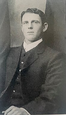
John King Davis was an English-born Australian explorer and navigator notable for his work captaining exploration ships in Antarctic waters as well as for establishing meteorological stations on Macquarie Island in the subantarctic and on Willis Island in the Coral Sea.

The Western Base Party was a successful exploration party of the Australasian Antarctic Expedition. The eight-man Western Party was deposited by the SY Aurora on the Shackleton Ice Shelf at Queen Mary Land. The leader of the team was Frank Wild and the party included the geologist Charles Hoadley.

Labbé Point is a point projecting 600 m (660 yd) into the southwest part of Discovery Bay from Parvomay Neck, Greenwich Island in the South Shetland Islands, Antarctica with an adjacent ice-free area of 11 hectares. The point forms the northwest side of the entrance to Basullo Cove and the east side of the entrance to Vinett Cove. The small Basso Island is linked by a mainly submerged spit to the north side of Labbé Point.

The Tryne Islands are a group of numerous small Antarctic islands and rocks, about 7 km (4 mi) in extent, forming the western limit of Tryne Bay and Tryne Sound at the north-eastern end of the Vestfold Hills. The islands were mapped by Norwegian cartographers from aerial photographs taken by the Lars Christensen Expedition (1936–37) and named Trynøyane.

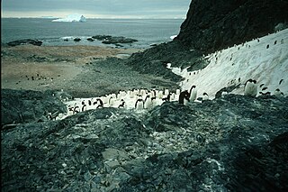
Ardley Island is an island 1.9 kilometres (1 nmi) long, lying in Maxwell Bay close off the south-west end of King George Island, in the South Shetland Islands of Antarctica. It was charted as a peninsula in 1935 by Discovery Investigations personnel of the Discovery II and named for Lieutenant R.A.B. Ardley, Royal Naval Reserve, an officer on the ship in 1929–31 and 1931–33. Aerial photography has since shown that the feature is an island with Braillard Point being the headland forming the northeast end of Ardley Island. It has been designated an Antarctic Specially Protected Area because of the importance of its seabird colonies.
Nelly Island is the largest and easternmost of the Frazier Islands, lying in Vincennes Bay off Wilkes Land, East Antarctica.
Dewart Island is the central island in the Frazier Islands, in Vincennes Bay, Wilkes Land, East Antarctica.
Turner Island is an island in the Donskiye Islands group lying 0.9 km (0.6 mi) north-west of Bluff Island and 4.6 km (2.9 mi) west of Breidnes Peninsula, Vestfold Hills, in Prydz Bay, Princess Elizabeth Land, Antarctica.

The Edwards Islands are a group of about 20 small islands, mostly ice free in summer, lying off the south-western tip of the Canisteo Peninsula, which projects into the eastern Amundsen Sea between Cranton and Ferrero Bays, on the Walgreen Coast of Marie Byrd Land, Antarctica. They were plotted from air photos taken by U.S. Navy Squadron VX-6 in January 1960, and were named by the Advisory Committee on Antarctic Names for Z T Edwards, chief quartermaster on the USS Glacier during the U.S. Navy Bellingshausen Sea Expedition to this area in February 1960.
Gibbney Island is a small island on the west side of Holme Bay, off Mac. Robertson Land, Antarctica. It was mapped by Norwegian cartographers from air photos taken by the Lars Christensen Expedition, 1936–37, and named "Bryggeholmen". It was renamed by the Antarctic Names Committee of Australia for L.F. Gibbney, officer in charge at Heard Island station in 1952.
Lucas Island is a small island lying just west of the Vestfold Hills, Antarctica, 4 kilometres (2 nmi) north-west of Plog Island. It was mapped by Norwegian cartographers from air photos taken by the Lars Christensen Expedition (1936–37) and called "Plogsteinen". It was mapped by the Australian National Antarctic Research Expeditions in 1958 and renamed for W.C. Lucas, a diesel mechanic at Davis Station, 1957.
Hawker Island is an irregularly shaped island about 2 km (1.2 mi) long, lying some 7 km south-west of Davis Station between Mule Island and Mule Peninsula, Vestfold Hills, in the eastern part of Prydz Bay, Antarctica. It was mapped by Norwegian cartographers from aerial photographs taken by the Lars Christensen Expedition, 1936–37. It was remapped by the Australian National Antarctic Research Expeditions (1957–58) and named after Alan Charles Hawker, a radio supervisor at Davis Station in 1957.
The Mackellar Islands, also MacKellar Islets, are a group of about 30 small islands and rocks lying 3 kilometres (1.5 nmi) north of Cape Denison in the center of Commonwealth Bay, George V Land, Antarctica. They were discovered by the Australasian Antarctic Expedition (1911–14) under Douglas Mawson, who named them for C.D. Mackellar of London, a patron of the expedition. The largest is Greater Mackellar Island.
Kartografov Island is a small coastal island lying in the western part of the mouth of Harald Bay, Oates Land, Antarctica. It was photographed by U.S. Navy Operation Highjump (1946–47), the Soviet Antarctic Expedition (1957–58) and the Australian National Antarctic Research Expedition (1959). The island was named "Ostrov Kartografov" by the Soviet expedition.
Lagotellerie Island is an island 1.9 kilometres (1 nmi) long, lying 3.7 kilometres (2 nmi) west of Horseshoe Island in Marguerite Bay, off the west coast of Graham Land, Antarctica. It was discovered and named by the French Antarctic Expedition, 1908–10, under Jean-Baptiste Charcot.