
Addington Square is a Georgian and Regency garden square in Camberwell in the London Borough of Southwark which is named after the early 19th century prime minister Henry Addington. [1]
Addington Square is a Georgian and Regency garden square in Camberwell in the London Borough of Southwark which is named after the early 19th century prime minister Henry Addington. [1]
Addington Square is an unusually well-preserved conservation area [2] with the houses that make up the east, south and west sides of the square listed Grade II. [3] [4] [5] [6] [7] [8] [9] [10] On the north side is the Southwark City Tennis Club / Burgess Park Tennis Centre. [11]
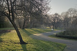
Because three sides of the square back onto Burgess Park and there is no through traffic, it is a peaceful space popular with lunchtime office workers. This controlled access, period buildings and proximity to central London also make it popular with film crews.
In the 1960s, the square was the base of the Richardson Gang, a south London rival to the Kray twins. They ran a private drinking club from the square, [12] [13] which had "Mad" Frankie Fraser and two dancing bears [14] in residence. [15] According to the gang's Old Bailey trial in 1967, the club was used to kangaroo court and torture rivals. The bears escaped onto Camberwell Road one night. [16]
More than a century earlier, one of the founders of the National Trust, Robert Hunter had been born in the square in 1844, [17] and it was also the home of Liberal politician Charles Masterman. [18] [19]
Construction of the square in the early 1800s came with the Grand Surrey Canal which terminated at Camberwell Wharf lying on the north side of the square. The first house in the square (now number 48) was completed by 1810 and owned by Nathaniel Simmons who was the engineer to the Grand Surrey Canal Company. Most of the rest of the square was built by 1827, and the square was complete by 1844. The 1851 census shows 32 houses with 179 residents and 33 servants, an occupancy rate of 6.2 persons per house. Nikolaus Pevsner points out in his The Buildings of England that as the construction was completed over a period of time (unlike most North London squares) "uniformity was abandoned" leading to "the pleasant irregular early c19 houses and terraces around Addington Square."
It was completed as a private square in 1855. By 1897 the square had become derelict, but was renovated and opened for public use; the Metropolitan Public Gardens Association donated six seats in 1898. [20]
There were also public baths and a swimming pool on the north side until the turn of the 19th/20th centuries, and a scandal involving a parson in bathhouse activities is commemorated in a rare satirical poem found in the library of Cornell University. [21] In the late 1930s the King George's Fields Foundation gave a grant of £1,000 towards the cost of £5,363 of acquiring the former swimming pool and turning it into a public garden. [22] [23]
In 2008 it was used as the location for the electronic duo Goldfrapp's music video for their single "Happiness", which features on their fourth studio album, Seventh Tree . The video focused on a young man in a white suit joyfully jumping down the streets in Addington Square, and featured the duo in a variety of cameos.
Camberwell is a district of South London, England, in the London Borough of Southwark, 2+3⁄4 miles southeast of Charing Cross.

The London Borough of Southwark in South London forms part of Inner London and is connected by bridges across the River Thames to the City of London and London Borough of Tower Hamlets. It was created in 1965 when three smaller council areas amalgamated under the London Government Act 1963. All districts of the area are within the London postal district. It is governed by Southwark London Borough Council.
Walworth is a district of south London, England, within the London Borough of Southwark. It adjoins Camberwell to the south and Elephant and Castle to the north, and is 1.9 miles (3.1 km) south-east of Charing Cross.

East Dulwich is an area of South East London, England in the London Borough of Southwark. It forms the eastern part of Dulwich, with Peckham to the east and Camberwell to the north. This South London suburb was first developed in the nineteenth century on land owned by the College of God's Gift.

Old Kent Road is a major thoroughfare in South East London, England, passing through the London Borough of Southwark. It was originally part of an ancient trackway that was paved by the Romans and used by the Anglo-Saxons who named it Wæcelinga Stræt. It is now part of the A2, a major road from London to Dover. The road was important in Roman times linking London to the coast at Richborough and Dover via Canterbury. It was a route for pilgrims in the Middle Ages as portrayed in Chaucer's Canterbury Tales, when Old Kent Road was known as Kent Street. The route was used by soldiers returning from the Battle of Agincourt.

Burgess Park is a public park situated in Camberwell the London Borough of Southwark, and is close to Walworth to the north, Bermondsey to the east and Peckham to the south. At 56 hectares, it is one of the largest parks in South London.

Denmark Hill railway station is in the area of Denmark Hill in south London, England, on the South London and Catford Loop lines. It is 4 miles 22 chains (6.9 km) down the line from London Victoria. It is managed by Thameslink.
Tower Hill is infamous for the public execution of high status prisoners from the late 14th to the mid 18th century. The execution site on the higher ground north-west of the Tower of London moat is now occupied by Trinity Square Gardens.

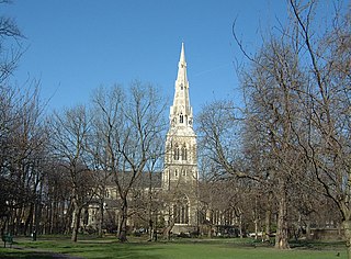
The London Borough of Southwark, occupying a roughly triangular area south of Tower Bridge over the River Thames, considers itself to be one of the greenest boroughs in London, with its 245 hectares of public parkland. There are more than 130 such green areas, ranging from the large areas around Dulwich and Southwark Park in Rotherhithe to the many sports grounds and squares. The main ones are:

Peckham was a borough constituency in South London which returned one Member of Parliament (MP) to the House of Commons of the Parliament of the United Kingdom. Elections were held using the first-past-the-post voting system.

Sydenham Hill Wood is a ten-hectare wood on the northern slopes of the Norwood Ridge in the London Borough of Southwark. It is designated as a Local Nature Reserve and Site of Metropolitan Importance for Nature Conservation. With the adjacent Dulwich Wood, Sydenham Hill Wood is the largest extant tract of the ancient Great North Wood. The two woods are formed from coppices known as Lapsewood, Old Ambrook Hill Wood and Peckarmans Wood after the relocation of The Crystal Palace in 1854 and the creation of the high level line in 1865.

Christ Church, Southwark, is a church of the Anglican denomination situated on the west side of Blackfriars Road, London. At the time of the foundation there was no bridge at Blackfriars and so no major road connecting the area to the south or to the City.
Myatt's Fields Park is a 14-acre Victorian park in Camberwell in the London Borough of Lambeth in South London, England, 2.9 miles south-east of Charing Cross.

Francis Octavius Bedford (1784–1858) was an English ecclesiastical architect, who designed four Greek Revival churches in south London during the 1820s. He later worked in the Gothic style.

Ruskin Park is a park in the London Borough of Lambeth, London, England, close to Camberwell, Loughborough Junction and Herne Hill.

Camberwell Grove is a residential street in Camberwell, London, England, in the Borough of Southwark. It follows the line of a grove of trees, hence the name. The street once led from a Tudor manor house south to the top of a hill, which afforded a view of the City of London, approximately three miles to the north. Today, the grove is part of Camberwell Grove Conservation area.
Madeline Agnes Agar was a British landscape designer. She was an early professional female landscape designer in Britain, and responsible for the design and the layout of a number of public gardens across London in the early 20th-century. She was the second woman to be the landscape gardener for the Metropolitan Public Gardens Association and was an author of books on gardening.
The Metropolitan Public Gardens Association is a charity in London for the purposes of the preservation of public parks and gardens, established in 1882. It facilitated the creation of new public open spaces, including from philanthropic landowners within its membership. The MPGA was involved in the formation and development of other amenity organisations. The charity still exists; in recent decades its emphasis has changed to smaller parcels of land and smaller projects within larger spaces, as well as to themed projects. The MPGA was the starting point for the careers of the ground-breaking female landscape gardeners Fanny Wilkinson and Madeline Agar.
Brunswick Park is a 4-acre (1.6 ha) public park located in Camberwell, in South East London, and is managed by the London Borough of Southwark. Originally a private square, the park was opened to the public in 1907.