Ladbroke Grove is an area and a road in North Kensington in the Royal Borough of Kensington and Chelsea, passing through Kensal Green and Notting Hill, running north–south between Harrow Road and Holland Park Avenue.

The May Fair Hotel is a luxury hotel on Stratton Street in Mayfair, London, near the site of Devonshire House in Piccadilly. It opened in 1927 with King George V and Queen Mary in attendance. The hotel is now owned by Edwardian Hotels, and Inderneel Singh, son of the chairman and CEO Jasminder Singh, is the managing director.

Addison Road is a road in London, England, which connects Kensington High Street with Notting Hill and Holland Park Avenue, and runs nearby to Holland Park.

Homer Row is a street in the Marylebone district of the City of Westminster, London, that runs form Old Marylebone Road in the north to the junction of Crawford Place and Crawford Street in the south.

Cranbourn Street is a street in Central London. It connects Leicester Square to Long Acre via Charing Cross Road.

Russia Row is a street in the City of London that runs between Milk Street and Trump Street on the northern side of the former Honey Lane Market. Russia Court, formerly Robin Hood Court, the home of the Russia Company, was once located on the northern side of the street and the City of London School on the south side. The street is thought to have received its name around 1804, shortly before Russia decided to enter the Napoleonic Wars on the same side as Britain. It was damaged by German bombing during the Second World War and has since been completely rebuilt.
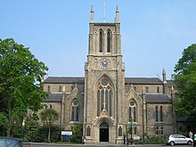
Abercorn Place is a street in St John's Wood in London. Located in the City of Westminster, it runs west to east from the Edgware Road at Maida Vale until it joins Abbey Road not far from the Abbey Road Studios to the south. It is crossed by Hamilton Terrace. The street is named after the Duke of Abercorn, an Anglo-Irish aristocrat. It was part of an estate originally owned by Harrow School of which Abercorn was a governor with other nearby streets similarly named. The street contains a mixture of housing from the 1820s onwards. Several buildings in the street are listed today. The Anglican St Mark's Church was built in 1847 at the intersection with Hamilton Terrace. It was designed in the Gothic style by the architect Thomas Cundy.
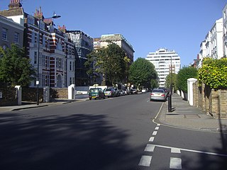
Randolph Avenue is a street in Maida Vale in London. Located in the City of Westminster, it is a long avenue running from north to south. The southern end is located in Little Venice near to the Paddington branch of the Grand Union Canal. The street runs northwards, crossing Clifton Gardens, Sutherland Avenue, Elgin Avenue and Carlton Vale. The road then continues as Randolph Gardens until it meets Kilburn Park Road. The Edgware Road runs directly parallel to Randolph Avenue to the east.

Warrington Crescent is a street in Maida Vale in London. Located in the City of Westminster, it is a crescent curving north eastwards from Warwick Avenue until it reaches a roundabout where it meets including Randolph Avenue, Sutherland Avenue and Lauderdale Road. Warrington Gardens and Formosa Street both lead westwards off Warrington Crescent.
Sutherland Avenue is a street in Maida Vale in London, England. Located in the City of Westminster on the northern edge of Little Venice. it is an avenue running east to west from the Edgware Road to Harrow Road. Along the route it is crossed or joined by Randolph Avenue, Warrington Crescent, Lauderdale Road, Castellian Road, Warwick Avenue and Shirland Road. Elgin Avenue runs directly parallel to the north.

Kilburn Lane is a street in Northwest London which runs through North Kensington, London and Kilburn, London. It’s route marks the boundary between the City of Westminster and the London Borough of Brent. To the east it continues into South Kilburn as Carlton Vale. At the western end the street curves southwards until it meets Harrow Road, becoming Ladbroke Grove and continuing across the Grand Union Canal.

Gloucester Avenue is a street in the Primrose Hill area of London, England. Located in the London Borough of Camden, it is a residential road featuring many nineteenth century properties including several pubs as well as the neo-Georgian Cecil Sharp House. For much of its route it runs adjacent to the West Coast Main Line out of Euston Station.

Arlington Road is a street running between Mornington Crescent and Camden Town in the London Borough of Camden, England. It runs south to north, directly parallel to Camden High Street to its east. It is crossed by Inverness Street, Parkway and Delancey Street. It is near Gloucester Crescent. It is mainly residential, with a few commercial properties.

Norfolk Square is a rectangular garden square in Paddington in Central London. Located in the City of Westminster, it is part of the Tyburnia district north of Hyde Park. It runs east to west from London Street to Norfolk Place. Praed Street and Sussex Gardens are directly parallel to it north and south respectively.

Norland Square is a garden square in the Notting Hill area of London. Located in the Royal Borough of Kensington and Chelsea, runs northward from Holland Park Avenue to Queensdale Road. The mews street Norland Place runs eastwards of the Square.

St Ann's Villas is a street in the Notting Hill area of London. Located in the Royal Borough of Kensington and Chelsea, it runs northwards from Royal Crescent. It is intersected by Queensdale Road.

Connaught Street is a street in Central London. Located in the City of Westminster, it is part of the Tyburnia area of Paddington north of Hyde Park. It runs west to east from Hyde Park Square to the Edgware Road. It continues eastwards becoming Upper Berkeley Street in Marylebone. The street contains a mixture of commercial and residential properties, forming part of Connaught Village. Connaught Square and Albion Street are located on its southern side. The Duke of Kendal public house sits at the junction between Connaught Street and Kendal Street.

Albion Street is a residential street located in Central London in the City of Westminster. Part of the Tyburnia area, it runs southwards from Connaught Street to the Bayswater Road on the edge of Hyde Park. It is notable for its Regency architecture.
North End Way is a street in Hampstead in the London Borough of Camden, today a stretch of the A502 road. At the boundary with the London Borough of Barnet it becomes North End Road running northwards into Golders Green where it terminates at the junction with Finchley Road, by the tube station. North End Way passes through Hampstead Heath.