History
Prior to the adoption of the 1995 constitution, a portion of this Zone (particularly the northern part) was part of Tigray Province. [2] As a result, a UNDP mission visiting the Zone described it as "the most isolated zone of the Afar National Regional State", at the time showing signs of "suffered heavily from bombardment, as well as from general neglect. Much of the remaining infrastructure dates from the Haile Selassie era." [3]

Tigray is a historical region and province of Ethiopia. It encompasses most of the territories of Tigrinya-speakers in Ethiopia; Tigray is separated from the northern Tigrinya territories by the River Mereb, now serving as the state border to Eritrea.
At the time the UNDP visited, they observed two major socio-political issues in the Zone. The first was a smoldering conflict between the Afar Revolutionary Democratic Unity Front (ARDUF) and government forces. The ARDUF conducted sporadic attacks on government military forces and officials and competed for control of the salt trade. In response, the military closed markets at Berhale, Garamoyti, Gaharta, ‘Ala, Mergis and Dande, and schools in at least three woredas. The second was the continued influx of rural Afar, primarily nomads, from Eritrea. These new arrivals claimed to be fleeing the Eritrean government’s recent enforcement of its National Service programme and a parallel agenda of disarmament. Despite a lack of external assistance, these refugees were given assistance and shelter due to clan ties between them and the locals. [3]

The Afar Revolutionary Democratic Unity Front is an Afar political party in Ethiopia that was founded in 1993 and is currently part of the United Ethiopian Democratic Forces (UEDF) coalition opposition party.
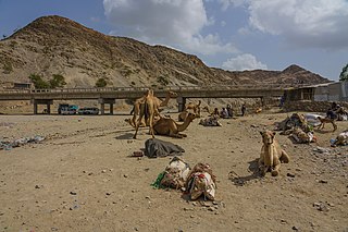
Berhale is a town in north-eastern Ethiopia. Located in the Administrative Zone 2 of the Afar Region, this town has a latitude and longitude of 13°51′N40°01′E with an altitude of 639 meters above sea level. It is the largest town in Berhale woreda.
Demographics
Based on the 2007 Census conducted by the Central Statistical Agency of Ethiopia (CSA), this Zone has a total population of 350,111, of whom 195,404 are men and 154,707 women. While 26,217 or 7.49% are urban inhabitants, a further 38,249 or 10.93% were pastoralists. Two largest ethnic groups reported in Zone 2 were the Afar (96.04%) and Tigray (3.29%); all other ethnic groups made up 0.67% of the population. Afar is spoken as a first language by 96%, and Tigrinya by 3.31%; the remaining 0.69% spoke all other primary languages reported. 96.54% of the population said they were Muslim, and 3.4% were Orthodox Christians. [4]

The Afar, also known as the Danakil, Adali and Odali, are an ethnic Cushitic peoples inhabiting the Horn of Africa. They primarily live in the Afar Region of Ethiopia and in northern Djibouti, although some also inhabit the southern point of Eritrea. Afars speak the Afar language, which is part of the Cushitic branch of the Afroasiatic family.
The Afar language is an Afroasiatic language belonging to the Cushitic branch. It is spoken by the Afar people inhabiting Djibouti, Eritrea and Ethiopia.
Tigrinya language, is a Semitic language spoken by people of southern Eritrea and across the broader by people of Tigray region. Tigrinya is also spoken by groups of emigrants from these regions, including some Beta Israel.
The 1996 national census reported a total population for this Zone of 218,721, of whom 121,598 were men and 97,123 women; 4,990 or 2.3% of its population were urban dwellers at the time. The major ethnic groupings in 1996 were 97.73% Afar and 2.16% Tigrean. Of the school-age school-age children, 2.31 (3.25% male and 1.10% female) were currently attending school, which is lower than the Regional average; 4.16% of the total population over the age of 10 (6.26% male and 1.5% female) are reported to be literate. [5]

Mi'irabawi is the westernmost Zone of the Tigray Region in Ethiopia. It is subdivided into three woredas (districts); from north to south they are Kafta Humera, Wolqayt and Tsegede. Major towns and cities include Humera. Mi'irabawi is bordered on the east by the Semien Mi'irabawi Zone, the south by the Amhara Region, the west by Sudan and on the north by Eritrea.

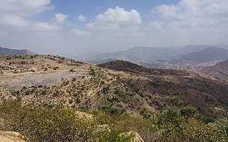
Mebrak is a Zone in the Ethiopian Region of Tigray. Misraqawi is bordered on the east by the Afar Region, on the south by Debub Misraqawi, on the west by Mehakelegnaw (Central) and on the north by Eritrea. Its highest point is Mount Asimba. Towns and cities in Misraqawi include Adigrat, Atsbi, Hawzen, and Wiqro.

Debubawi is one of the Zones in the Ethiopian Region of Tigray. Debubawi is bordered on the south and west by the Amhara Region, on the north by Debub Misraqawi (Southeastern) Zone, and on the east by the Afar Region. Towns and cities in Debubawi include Korem, Alamata. Debub Misraqawi (Southeastern) Zone was separated from Debubawi Zone.

Semien Shewa is one of 10 Zones in the Ethiopian Amhara Region. Semien Shewa takes its name from the kingdom or former province of Shewa. The Zone is bordered on the south and the west by the Oromia Region, on the north by Debub Wollo, on the northeast by the Oromia Zone, and on the east by the Afar Region. The highest point in the Zone is Mount Abuye Meda ; other prominent peaks include Mount Megezez. Towns and cities in Semien Shewa include Ankober, Debre Berhan, and Shewa Robit.
Liben is one of the eleven zones of the Somali Region of Ethiopia. Liben is bordered on the south by Kenya, on the northwest by the Oromia Region, on the northeast by Afder, and on the southeast by Somalia. Towns in Liben include Sathe, Softu and Dolo.

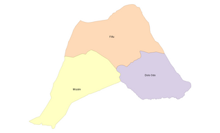
Administrative Zone 3 is one of five Zones of the Afar Region of Ethiopia. This zone is bordered on the south by the Oromia Region, on the southwest by the Amhara Region, on the west by the Administrative Zone 5, on the north by Administrative Zone 1, and on the east by the Somali Region.

Administrative Zone 4 is one of five Zones of the Afar Region of Ethiopia. This zone is bordered on the south and east by Administrative Zone 1, on the southwest by the Amhara Region, on the northwest by the Tigray Region, and on the north by Administrative Zone 2. The administrative center of the Zone is Kelewina; the largest town is Dibina.

Administrative Zone 5 is one of five Zones of the Afar Region of Ethiopia. Stretching along the eastern base of the Ethiopian highlands, this Zone is bordered on the south and east by Administrative Zone 3, on the west by the Amhara Region, and on the north by Administrative Zone 1.

Welkait is a woreda and region in northwestern Ethiopia, part of the West Zone of Tigray Region. The woreda is bordered to the north by Kafta Humera and to the south by Tsegede; these are the other two woredas of Mi'irabawi Zone in Tigray. It is bordered on the east by the North West Zone; the woredas of Tahtay Adiyabo and Asgede Tsimbla lie to the north-east, on the other side of the Tekezé River, and Tselemti is to the east. The administrative center of Welkait is Addi Remets; other towns in the woreda include Mai'gaba and Awura.

Irob is one of the woredas in the Tigray Region of Ethiopia. This woreda is named after the Irob people, who are the predominant ethnic group living there. Located in the Misraqawi Zone at the eastern escarpment of the Ethiopian highlands, Irob is bordered on the south by Saesi Tsaedaemba, on the west by Gulomahda, on the north and east by the Endelli River which separates it from Eritrea, and on the southeast by the Afar Region. The administrative center of this woreda is Dawhan; other towns include Alitena, the former administrative center.
Afdera is one of the woredas in the Afar Region of Ethiopia. It is named after the saline Lake Afdera, located in the southern part of the Afar Depression. Part of the Administrative Zone 2, Afdera is bordered on the southwest by the Administrative Zone 4, on the west by Erebti and Abala, on the north by Berhale, on the northeast by Eritrea, and on the southeast by Administrative Zone 1. The largest towns of this woreda is Afdera.
Bure Mudaytu is one of the woredas in the Afar Region of Ethiopia. Part of the Administrative Zone 3, Bure Mudaytu stretches along a narrow band covering the marshy lowlands along the Awash River, with the Administrative Zone 5 to the west and Gewane to the east. The administrative center of this woreda is Debel.

Kafta Humera is one of the woredas in the Tigray Region of Ethiopia. Part of the West Tigray Zone, Kafta Humera is bordered on the south by Tsegede, on the west by Sudan, then by the Tekezé River which separates Kafta Humera from Eritrea on the north and Semien Mi'irabawi Zone on the east, and on the southeast by Wolkayt. Towns in Kafta Humera include Adi Hirdi and Humera.
Tahtay Adiyabo is one of the woredas in the Tigray Region of Ethiopia. Part of the Semien Mi'irabawi Zone, Tahtay Adiyabo is bordered on the south by the Asigede Tsimbela, on the southwest by the Tekezé River which separates Tahtay Adiyabo from the Mi'irabawi Zone, on the north by Eritrea, and on the east by La'ilay Adiyabo; part of the northern border with Eritrea is delineated by the Mareb River. The northernmost point of this woreda is the northernmost point of Ethiopia. Towns in this woreda include Addi Awuala and Addi Hageray. The town of Shiraro is surrounded by Tahtay Adiyabo.

Gulomakeda is one of the woredas in the Tigray Region of Ethiopia. Its name partly comes from the legendary Queen Makeda, also known as the Queen of Sheba. Part of the Misraqawi Zone, Gulomakeda is bordered on the south by Ganta Afeshum, on the west by the [zoba Maekel (Central)], on the north by Eritrea, on the east by Irob, and on the southeast by Saesi Tsaedaemba. Towns in Gulomakeda include Fatsi, Sebeya and Zalambessa. Gulomakeda has many historical places like Debredamo. Wereda Gulomakeda has 2 preparatory schools Yemane senior secondary school and Zalambessa senior secondary school. Notable local landmarks in this woreda include ruins that have been dated to the Axumite Kingdom, as well as to the period prior to its rise. Archeological surveys conducted by Dr. Catherine D'Andrea of Simon Fraser University show that far from being a rural hinterland, Gulomakeda had large towns with elite groups who had access to exotic trade goods during that time. She also identified cultural links to ancient Eritrean settlements, which included Matara and the ancient Ona culture.
Raya Azebo (Tigrinya: ራያ ዓዘቦ) is one of the woredas in the Tigray Region of Ethiopia. Located in the Debubawi Zone at the eastern edge of the Ethiopian highlands, Raya Azebo is part of the Southern Tigray Region. The administrative center of this woreda is Mekoni. Other towns in Raya Azebo include Weyra Wuha, Chercher, Adi Abdera, Kukufto, Bala and Hade Alga.
Abala is one of the woredas in the Afar Region of Ethiopia. Part of the Administrative Zone 2, Abala is located at the base of the eastern escarpment of the Ethiopian highlands, and bordered on the south by Megale, on the west by the Tigray Region, on the north by Berhale, on the northeast by Afdera, and on the east by Erebti. The major town in Abala is Abala.


