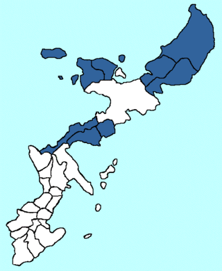
The administrative divisions of the Ryukyu Kingdom were a hierarchy composed of districts, magiri, or Okinawan : majiri cities, villages, and islands established by the Ryukyu Kingdom throughout the Ryukyu Islands. [2]
There were three districts (方) or hō: Kunigami (国頭), Nakagami (中頭), and Shimajiri (島尻), which roughly correspond to the borders of the three Okinawan kingdoms during the Sanzan period. There were 57 magiri (間切, Okinawan: majiri [3] ) throughout the kingdom including the Amami Islands. In concept they were similar to present-day Japanese prefectures, but in size they were closer to Japanese cities, towns and villages. There were four cities: Shuri (首里), Naha (那覇), Tomari (泊), and Kume (久米). They were comparable to Japanese urban prefectures. There were over 600 villages (村, Okinawan: mura [4] [5] ) throughout the kingdom including the Amami Islands. [lower-alpha 3] There were approximately 24 shima (島) or "outlying islands", but only including islands that weren't already part of a magiri.
The three districts are based on the three kingdoms of Hokuzan, Chūzan, and Nanzan. The origin of the magiri system is unclear, but was solidified by the beginning of the reign of Shō Shin, the third king of the Second Shō Dynasty of the Ryukyu Kingdom who ruled between 1477 and 1526. [7] The magiri were originally controlled by individual aji and oyakata, [5] [8] whose ruling area overwrapped in parts. [9] While as the Ryukyu Kingdom centralized at the turn of the 15th century, the aji relocated to the capital of the kingdom at Shuri. After this period the title of aji became symbolic, and low-ranking officials were assigned the day-to-day administration of the magiri. [7]
Each magiri had several villages, sometimes referred to as shima, which represented an administrative unit similar to the mura, or village, in feudal Japan. [9] Each magiri had five to ten villages. Ryukyuan commoners were registered to a particular village, and movement to or from the administrative areas was generally not permitted. Under the system of Shō Shin the central government at Shuri assigned each village a noro priestess to carry out the religious functions of the settlement. [7] [10] The area was mapped on the Ryukyu kuni-ezu (琉球國絵図 of 1696 or 9th year of Genroku) [lower-alpha 4] was compiled. That made it possible for the first time, to clarify the geopolitical location of ancient place names. [12]
The magiri system continued to varying degrees in the Amami Islands even after they were ceded to Satsuma Domain in 1624. On Okinawa Island, there were 27 magiri at the turn of the 17th century, but by the 19th century Misato, Kushi, Motobu, Ginowan, Oroku, Onna, Ōgimi, and Yonagusuku were created, bringing the total to 35. The magiri system continued after the end of the Ryukyu Kingdom and annexation of the islands by Japan in 1879. [13] In 1907, under Imperial Edict 46 , the Japanese administrative system of cities, towns, and village organization was extended to Okinawa. [2] The magiri system was officially abolished on April 1, 1908. [7]
The following is a list of magiri by district:
Kunigami District (国頭方, Kunigami-hō, Okinawan: Kunjan-hō), also known as Okinawan: Yanbaru [14] and Kunigami [15] or Hokuzan-fu (北山府) in Kanbun, [16] roughly correspond to the territory of Hokuzan during the Sanzan period.
Area | Name | Kanji | Okinawan name | present-day | notes |
---|---|---|---|---|---|
Northern area of Okinawa Main Island and nearby islands | Kunigami | 国頭間切 | Kunjan | Kunigami | |
Ōgimi | 大宜味間切 | Wujimi | Ōgimi | established in 1673; changed name from Taminato (田港) in 1695 | |
Iheya | 伊平屋間切 | Ihya | Iheya, Izena | ||
Haneji | 羽地間切 | Haniji | Nago (Haneji area, Yagaji area) | ||
Nakijin | 今帰仁間切 | Nachijin | Nakijin | ||
Motobu | 本部間切 | Mutubu | Motobu | established in 1666; changed name from Inoha (伊野波) in 1667 | |
Nago | 名護間切 | Nagu | Nago, excluding Haneji and Yagaji areas | ||
Kushi | 久志間切 | Kushi | Higashi and part of Nago | established in 1673 | |
Kin | 金武間切 | Chin | Kin, Ginoza | ||
Southern Amami Islands | Erabu | 永良部間切 | Irabu | China, Wadomari, (Kagoshima Prefecture | de facto incorporated into Satsuma Domain (Ōsumi Province) since 1624; de jure remained a part of Ryukyu Kingdom |
Yoron | 与論間切 | Yunnu | Yoron | ||
Nakagami District (中頭方, Nakagami-hō, also known as Okinawan: Wiikata) [17] or Chūzan-fu (中山府) in Kanbun, [16] roughly correspond to the territory of Chūzan during the Sanzan period.
Area | Name | Kanji | Okinawan name | present-day | notes |
---|---|---|---|---|---|
Central area of Okinawa Main Island and nearby islands | Onna | 恩納間切 | Unna | Onna | established in 1673 |
Yomitanzan | 読谷山間切 | Yuntanja | Yomitan | ||
Goeku | 越来間切 | Gwiiku | Okinawa City | ||
Misato | 美里間切 | Njatu | Okinawa City, Uruma (Ishikawa Area) | established in 1666 | |
Gushikawa | 具志川間切 | Gushichaa | Uruma (Gushikawa area) | ||
Katsuren | 勝連間切 | Kacchan | Uruma (Katsuren area) | ||
Yonashiro | 与那城間切 | Yunagushiku | Uruma (Yonashiro area) | established with the name Nishihara (西原) in 1676; changed name to Hirata (平田) in the same year; finally changed to Yonashiro in 1687. | |
Nishihara | 西原間切 | Nishibaru | Nishihara | ||
Chatan | 北谷間切 | Chatan | Chatan, Kadena, part of Okinawa City | ||
Nakagusuku | 中城間切 | Nakagushiku | present Nakagusuku, Kita-Nakagusuku, Uruma (Tsuken Island) | ||
Ginowan | 宜野湾間切 | Jinōn | present-day Ginowan | established in 1671 | |
Urasoe | 浦添間切 | Urashii | Urasoe | ||
Nakazato | 仲里間切 | Nakajatu | Kumejima (Nakazato area) | ||
Uezu | 上江洲間切 | Wiiji | Kumejima (Gushikawa area) | ||
Four cities (not included in magiri) | Tomari | 泊 | Tumai | Naha (northern area of Naha) | |
Naha | 那覇 | Nafa, Nafaa | Naha (southern area of Naha), Tokashiki, Zamami | contains 4 towns (町, machi): Wakasa-machi (若狭町, Okinawan: Wakasa-machi), Higashi-machi (東町, Okinawan: Figashi-machi), Nishi-machi (西町, Okinawan: Nishi-machi) and Izumizaki (泉崎, Okinawan: Ijunjachi) [18] | |
Kume | 久米 | Kuninda | Naha (Kume area) | community of Thirty-six families from Min. full name: Kumemura (久米村) Chinese name: Táng íng (唐營) before 1650; Táng róng (唐榮) since 1650 | |
Shuri Mihira | 首里三平等 | Sui Mifira | Naha (Shuri area, Mawashi area), Nishihara, Haebaru) | contains Shuri Castle and 3 hira (平等, Okinawan: fira): Mawashi no hira (真和志之平等, Okinawan: Maaji nu fira), Hae no hira (南風之平等, Okinawan: Fee nu fira) and Nishi no hira (西之平等, Okinawan: Nishi nu fira) [19] | |
Shimajiri District (島尻方, Shimajiri-hō, also known as Okinawan: Shimukata) [20] or Nanzan-fu (南山府) in Kanbun, [16] roughly correspond to the territory of Nanzan during the Sanzan period.
Area | Name | Kanji | Okinawan name | present-day | notes |
---|---|---|---|---|---|
Southern area of Okinawa Main Island and nearby islands | Tomigusuku | 豊見城間切 | Tumigushiku | Tomigusuku | |
Oroku | 小禄間切 | Uruku | Naha (Oroku area) | established in 1672 | |
Takamine | 高嶺間切 | Takanmi | Itoman (excluding Kyan and Mabuni areas) | changed name from Shimajiriōzato (島尻大里) in 1667 | |
Kyan | 喜屋武間切 | Chan | Itoman (Kyan area) | ||
Mabuni | 摩文仁間切 | Mabuni | Itoman (Mabuni area) | ||
Makabe | 真壁間切 | Makabi | Itoman (Makabe area) | ||
Kanegusuku | 兼城間切 | Kanigushiku | Itoman (Kanegusuku area) | also known as Okinawan: Shimajirikanegusuku | |
Kochinda | 東風平間切 | Kuchinda | Yaese (Kochinda area) | ||
Gushichan | 具志頭間切 | Gushichan | Yaese (Gushichan area) | ||
Ōzato | 大里間切 | Ufuzatu | Nanjō (Ōzato area), Yonabaru) | changed name from Shimazoeōzato (島添大里) in 1667 | |
Sashiki | 佐敷間切 | Sashichi | Nanjō (Sashiki area, Chinen area) | ||
Tamagusuku | 玉城間切 | Tamagushiku | Nanjō (Tamagusuku area) | ||
Area | Name | Kanji | Okinawan name | present-day | notes |
---|---|---|---|---|---|
Miyako Islands | Hirara | 平良間切 | Teera | Miyakojima (Hirara area) | |
Shimoji | 下地間切 | Shimuji | Miyakojima (Shimoji area, Ueno area) | ||
Sunakawa | 砂川間切 | Shinachaa | Miyakojima (Gusukube area) | ||
Yaeyama Islands | Ōhama | 大浜間切 | Ufuhama | Ishigaki | |
Miyara | 宮良間切 | Myaara | Ishigaki | ||
Ishigaki | 石垣間切 | Ishigachi | Ishigaki | ||
Area | Name | Kanji | Okinawan name | present-day | notes |
---|---|---|---|---|---|
Amami Ōshima | Kasari | 笠利間切 | Amami (Kasari area) | de facto incorporated into Satsuma Domain (Ōsumi Province) since 1624; de jure remained a part of Ryukyu Kingdom | |
Komi | 古見間切 | Tatsugō, Amami | |||
Naze | 名瀬間切 | Yamato, Amami | |||
Yakiuchi | 焼内間切 | Yamato, Uken | |||
Sumiyō | 住用間切 | Amami (Sumiyō area) | |||
Nishikata | 西方間切 | Setouchi | |||
Higashikata | 東方間切 | Setouchi | |||
Kikaijima | Shidooke | 志戸桶間切 | Kikai (Shidooke area) | ||
Higa | 東間切 | Kikai (Sōmachi area) | |||
Isago | 伊砂間切 | Kikai (Isago area) | de facto incorporated into Satsuma Domain (Ōsumi Province) since 1624; de jure remained a part of Ryukyu Kingdom established in 1693 | ||
Nishime | 西目間切 | Kikai (Nishime area) | de facto incorporated into Satsuma Domain (Ōsumi Province) since 1624; de jure remained a part of Ryukyu Kingdom | ||
Wan | 湾間切 | Kikai (Wan area) | |||
Araki | 荒木間切 | Kikai (Araki area) | |||
Tokunoshima | Higashi | 東間切 | Tokunoshima | ||
Omonawa | 面縄間切 | Unnō | Isen | ||
Nishime | 西目間切 | Amagi | |||
Kunigami is a district located in Okinawa Prefecture, Japan. Roughly translated, kunigami means "head of the country", referring to its northern location on the island of Okinawa. Compare this to Shimajiri District, Okinawa.
Kunigami is a village in Kunigami District, Okinawa Prefecture, Japan. It occupies the north tip of Okinawa Island, with the East China Sea to the west, Pacific Ocean to the east, and villages of Higashi and Ōgimi to the south.
Yomitan is a village located in Nakagami District, Okinawa Prefecture, Japan.
Nishihara is a town located in Nakagami District, Okinawa Prefecture, Japan. In the Okinawan language, nishi means "north", as Nishihara was north of the historical Ryukyuan capital of Shuri.
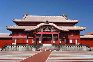
The Ryukyu Kingdom was a kingdom in the Ryukyu Islands from 1429 to 1879. It was ruled as a tributary state of imperial Ming China by the Ryukyuan monarchy, who unified Okinawa Island to end the Sanzan period, and extended the kingdom to the Amami Islands and Sakishima Islands. The Ryukyu Kingdom played a central role in the maritime trade networks of medieval East Asia and Southeast Asia despite its small size. The Ryukyu Kingdom became a vassal state of the Satsuma Domain of Japan after the invasion of Ryukyu in 1609 but retained de jure independence until it was transformed into the Ryukyu Domain by the Empire of Japan in 1872. The Ryukyu Kingdom was formally annexed and dissolved by Japan in 1879 to form Okinawa Prefecture, and the Ryukyuan monarchy was integrated into the new Japanese nobility.
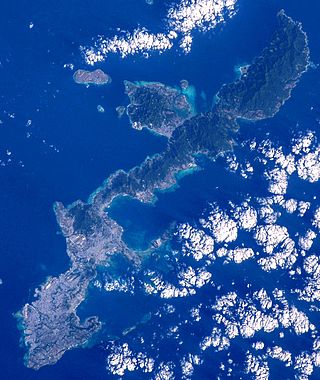
Okinawa Island, officially Okinawa Main Island, is the largest of the Okinawa Islands and the Ryukyu (Nansei) Islands of Japan in the Kyushu region. It is the smallest and least populated of the five main islands of Japan. The island is approximately 106 kilometres (66 mi) long, an average 11 kilometres (7 mi) wide, and has an area of 1,206.98 square kilometers (466.02 sq mi). It is roughly 640 kilometres south of the main island of Kyushu and the rest of Japan. It is 500 km northeast of Taiwan. The total population of Okinawa Island is 1,384,762. The greater Naha area has roughly 800,000 residents, while the city itself has about 320,000 people. Naha is the seat of Okinawa Prefecture on the southwestern part of Okinawa Island. Okinawa has a humid subtropical climate.
The Sanzan period is a period in the history of the Okinawa Islands when three lines of kings, namely Sanhoku, Chūzan and Sannan, are said to have co-existed on Okinawa Island. It is said to have started during King Tamagusuku's reign and, according to Sai On's edition of the Chūzan Seifu (1725), ended in 1429 when Shō Hashi unified the island. Historical records of the period are fragmentary and mutually conflicting. Some even question the co-existence of the three polities.
The Kunigami or Northern Okinawan language, is a Ryukyuan language of Northern Okinawa Island in Kunigami District and city of Nago, otherwise known as the Yanbaru region, historically the territory of the kingdom of Hokuzan.
Naha is the capital city of Okinawa Prefecture, the southernmost prefecture of Japan. As of 1 June 2019, the city has an estimated population of 317,405 and a population density of 7,939 people per km2. The total area is 39.98 km2 (15.44 sq mi).
Hokuzan, also known as Sanhoku (山北) before the 18th century, located in the north of Okinawa Island, was one of three independent political entities which controlled Okinawa in the 14th century during Sanzan period. The political entity was identified as a tiny country, a kingdom, or a principality by modern historians, however the ruler of Hokuzan was in fact not "kings" at all, but petty lords with their own retainers owing their direct service, and their own estates.
Shō Shin was a king of the Ryukyu Kingdom, the third ruler of the second Shō dynasty. Shō Shin's long reign has been described as "the Great Days of Chūzan", a period of great peace and relative prosperity. He was the son of Shō En, the founder of the dynasty, by Yosoidon, Shō En's second wife, often referred to as the queen mother. He succeeded his uncle, Shō Sen'i, who was forced to abdicate in his favor.
The Gusuku Sites and Related Properties of the Kingdom of Ryukyu is an UNESCO World Heritage Site which consists of nine sites all located in the Okinawa Prefecture, Japan. The heritage sites include two utaki, the Tamaudun mausoleum, one garden, and five gusuku castles sites, four of which are ruins and one of which is a reconstruction. The sites were inscribed based on the criteria that they were a fine representation of the Ryūkyū Kingdom's culture, whose unique blend of Japanese and Chinese influence made it a crucial economic and cultural junction between several neighboring states.
Masami Chinen was an Okinawan martial arts master who formed Yamani ryu. He taught Bōjutsu privately at his home in the village of Tobaru, in Shuri, Okinawa.
The Northern Ryukyuan languages are a group of languages spoken in the Amami Islands, Kagoshima Prefecture and the Okinawa Islands, Okinawa Prefecture of southwestern Japan. It is one of two primary branches of the Ryukyuan languages, which are then part of the Japonic languages. The subdivisions of Northern Ryukyuan are a matter of scholarly debate.
Noro are priestesses of the Ryukyuan religion at Utaki. They have existed since at least the beginning of the Gusuku period and continue to perform rituals even today. They are distinct from yuta (psychics), but are classified as kaminchu.
The military of the Ryukyu Kingdom defended the kingdom from 1429 until 1879. It had roots in the late army of Chūzan, which became the Ryukyu Kingdom under the leadership of King Shō Hashi. The Ryukyuan military operated throughout the Ryukyu Islands, the East China Sea, and elsewhere that Ryukyuan ships went. Ryukyu primarily fought with other Ryukyuan kingdoms and chiefdoms, but also Japanese samurai from Satsuma Domain and pirates. Soldiers were stationed aboard ships and Ryukyuan fortifications. The Ryukyuan military declined after the 17th century until it was abolished following the Japanese annexation of Ryukyu in 1879.
Amamikyu, or Amekushin-otome-ōankami (天久臣乙女王御神), is the creation goddess of the Ryukyu Islands in the Ryukyuan religion.
Ryūkyū-koku yurai-ki is a chorography compiled by the government of the Ryukyu Kingdom. It was the first chronography compiled by the royal government and was presented to King Shō Kei in 1713. It is an essential resource for Okinawan studies.
The Eiso dynasty (英祖王統) was the third dynasty in the traditional historiography of Okinawa Island. It was established by Eiso in 1259. Chūzan Seikan, the first official history of the Ryūkyū Kingdom, claimed that Eiso was a descendant of the ancient Tenson dynasty. During Gihon's reign, Okinawa sufferred from several terrible disasters, including storm, flood and famine. Around 1254, Gihon appointed Eiso to be regent (sessei). Seven years later, Gihon abdicated in favor of Eiso, whom established the Eiso dynasty in the same year. Gihon had to hand over his power because he was unable to manage these disasters and that discontent made it necessary to share authority with a representative chosen from the old Tenson chieftains; or a rival from Tenson chieftains forced Gihon to relinquish power. Though commonly called the "kings", the Okinawan rulers at that time should be more accurately identified as paramount chiefs, or overlords among aji during the Gusuku period.
King of Sanhoku was a title given to a line of local rulers on Okinawa Island from the late 14th century to the early 15th century. Contemporary sources on the Kings of Sanhoku are extremely scarce, and narratives on them have gradually been expanded over time. In historiography, the term Sanhoku conveniently refers to a realm supposedly under their control. Sanhoku is also known as Hokuzan (北山). The new term was coined in the 18th century by Sai On by flipping the two-character title.
The name written at the end of the rice yield entry reveals that the maps were created by the Satsuma Domain (Matsudaira Satsuma no Kami). Those maps along with the registries were designated as the Important Cultural Properties of Japan in 1983.
{{cite journal}}
: CS1 maint: ref duplicates default (link)Originals saved at: Cabinet Library, National Archives of Japan, and the Historiographical Institute of the University of Tokyo