
Azerbaijan is a country in the Caucasus region, situated at the juncture of Eastern Europe and West Asia. Three physical features dominate Azerbaijan: the Caspian Sea, whose shoreline forms a natural boundary to the east; the Greater Caucasus mountain range to the north; and the extensive flatlands at the country's center. About the size of Portugal or the US state of Maine, Azerbaijan has a total land area of approximately 86,600 km2, less than 1% of the land area of the former Soviet Union. Of the three Transcaucasian states, Azerbaijan has the greatest land area. Special administrative subdivisions are the Nakhchivan Autonomous Republic, which is separated from the rest of Azerbaijan by a strip of Armenian territory, and the Nagorno-Karabakh Autonomous Region, entirely within Azerbaijan. The status of Nagorno-Karabakh is disputed by Armenia, but is internationally recognized as territory of Azerbaijan.

Baku is the capital and largest city of Azerbaijan, as well as the largest city on the Caspian Sea and in the Caucasus region. Baku is 28 metres (92 ft) below sea level, which makes it the lowest lying national capital in the world and also the largest city in the world below sea level. Baku lies on the southern shore of the Absheron Peninsula, on the Bay of Baku. Baku's urban population was estimated at two million people as of 2009. Baku is the primate city of Azerbaijan—it is the sole metropolis in the country, and about 25% of all inhabitants of the country live in Baku's metropolitan area.

The Coral Sea Islands Territory is an external territory of Australia which comprises a group of small and mostly uninhabited tropical islands and reefs in the Coral Sea, north-east of Queensland, Australia. The only inhabited island is Willis Island. The territory covers 780,000 km2 (301,160 sq mi), most of which is ocean, extending east and south from the outer edge of the Great Barrier Reef and includes Heralds Beacon Island, Osprey Reef, the Willis Group and fifteen other reef/island groups. Cato Island is the highest point in the Territory.
Bulla Island, also Xara Zira, Khara Zira or Khere Zire, is an island south of the Bay of Baku, Caspian Sea. It is the largest island of the Baku Archipelago, located off Baku, Azerbaijan.

Boyuk Zira, also known as Nargin, is an island in the Caspian Sea. It is one of the islands of Baku Archipelago located in the Baku bay near Baku city. Nargin Island is part of the Baku Archipelago, which consists of the following islands: Boyuk Zira, Dash Zira, Qum Island, Zenbil, Sangi-Mugan, Chikil, Qara Su, Khara Zira, Gil, Ignat Dash and a few smaller ones.
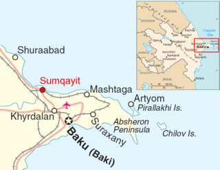
Chilov is an island in the Caspian Sea. It is located off the Absheron Peninsula, 55 kilometres (34 mi) east of Baku.

Dog Islands are a small group of islets among the British Virgin Islands in the Caribbean.

Bay of Baku is a natural harbor of the Baku port and local yacht club, on the southern shore of the Absheron Peninsula and on the western shore of the Caspian Sea.
Ogurja Ada is the largest island in both Turkmenistan and the Caspian Sea by area. Ogurja Island is also widely known by its Russian name Ogurchinskiy Island(Ostrov Ogurchinskiy).
Zanbil is a small island in the Caspian Sea off the Bay of Baku, Azerbaijan. It is also known as Duvanni Island.

The Baku Archipelago is a group of coastal islands close to Baku, Azerbaijan. The waters surrounding the islands are shallow.

Ahelaid is a small uninhabited islet in Estonia. It lies in the Baltic Sea, south-east of Hiiumaa island. It has a surface area of 25 hectares. It is part of the Hiiumaa Islets Landscape Reserve.

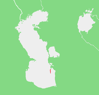
The Caspian Sea is the world's largest inland body of water, often described as the world's largest lake and sometimes referred to as a full-fledged sea. An endorheic basin, it lies between Europe and Asia: east of the Caucasus, west of the broad steppe of Central Asia, south of the fertile plains of Southern Russia in Eastern Europe, and north of the mountainous Iranian Plateau. It covers a surface area of 371,000 km2 (143,000 sq mi), an area approximately equal to that of Japan, with a volume of 78,200 km3 (19,000 cu mi). It has a salinity of approximately 1.2%, about a third of the salinity of average seawater. It is bounded by Kazakhstan to the northeast, Russia to the northwest, Azerbaijan to the southwest, Iran to the south, and Turkmenistan to the southeast.

Rail transport in Azerbaijan is operated by the national state-owned railway company Azerbaijan Railways. The railway network consists of 2,918 km (1,813 mi), its gauge is 1,520 mm, 815 km (506 mi) are double track and 1,272 km (790 mi) are electrified at 3 kV (3,000 V) DC.

Kura or Kurkosa, also known as Kurinskiy in the Russian language, is the largest island of Azerbaijan. It lies in the Caspian Sea, off the coast of the Aran Region, 33 kilometers (21 mi) to the south of Neftchala and about 150 kilometers (93 mi) to the SSE of Baku.
Kura Rock or Kura Stone, is an islet off the coast of Azerbaijan.
The Podvodnyye Islands are a small island group off the Azerbaijan coast in the Caspian Sea.
Dashli ada, Ignat Dash or Kamen Ignatiya is an island in the Caspian Sea. It is one of the islands of Baku Archipelago located in the Bay of Baku, 74 km to the south of Baku. Dashli ada is part of the Baku Archipelago, which consists of the following islands: Boyuk Zira, Dash Zira, Qum Island, Zenbil, Sangi-Mugan, Chikil, Qara Su, Khara Zira, Gil and a few smaller ones. The island is located 32.2 km east of Cape Bandovan. The closest island to Dashly - Adsiz Ada - is 13.9 km to the north. The island is of volcanic origin and has a mud volcano.

