
Azerbaijan is a country in the Caucasus region, situated at the juncture of Eastern Europe and West Asia. Three physical features dominate Azerbaijan: the Caspian Sea, whose shoreline forms a natural boundary to the east; the Greater Caucasus mountain range to the north; and the extensive flatlands at the country's center. About the size of Portugal or the US state of Maine, Azerbaijan has a total land area of approximately 86,600 km², less than 1% of the land area of the former Soviet Union. Of the three Transcaucasian states, Azerbaijan has the greatest land area. Special administrative subdivisions are the Nakhchivan Autonomous Republic, which is separated from the rest of Azerbaijan by a strip of Armenian territory, and the Nagorno-Karabakh Autonomous Region, entirely within Azerbaijan. The status of Nagorno-Karabakh is disputed by Armenia, but is internationally recognized as territory of Azerbaijan.
Pirallahı or Pirallahi may refer to:
Bulla Island, also Xara Zira, Khara Zira or Khere Zire, is an island south of the Bay of Baku, Caspian Sea. It is the largest island of the Baku Archipelago, located off Baku, Azerbaijan.

Boyuk Zira, also known as Nargin, is an island in the Caspian Sea. It is one of the islands of Baku Archipelago located in the Baku bay near Baku city. Nargin Island is part of the Baku Archipelago, which consists of the following islands: Boyuk Zira, Dash Zira, Qum Island, Zenbil, Sangi-Mugan, Chikil, Qara Su, Khara Zira, Gil, Ignat Dash and a few smaller ones.
Chilov is an island in the Caspian Sea. It is located off the Absheron Peninsula, 55 kilometres (34 mi) east of Baku.

Vulf, or Volf , and also known as Dash Zira or Kichik Zira(Kiçik Zirə), is an island of Azerbaijan, in the Caspian Sea. The word "Zira" originated in the Arabic word "Jazīra", meaning "island". Vulf is tiny and uninhabited. It is one of the many islands that protect the Bay of Baku.

The South Caucasus Pipeline is a natural gas pipeline from the Shah Deniz gas field in the Azerbaijan sector of the Caspian Sea to Turkey. It runs parallel to the Baku–Tbilisi–Ceyhan pipeline (oil).

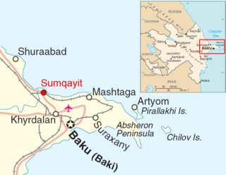
Bay of Baku is a natural harbor of the Baku port and local yacht club, on the southern shore of the Absheron Peninsula and on the western shore of the Caspian Sea.
Gil Island, also Glinyanii Island is an island of Azerbaijan in the Caspian Sea.
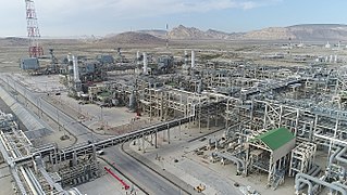
The Sangachal Terminal is an industrial complex consisting of a natural gas processing plant and oil production plant, located on the coast of the Caspian Sea 45 kilometres (28 mi) south of Baku, Azerbaijan.
Zanbil is a small island in the Caspian Sea off the Bay of Baku, Azerbaijan. It is also known as Duvanni Island.

Chikil, also known as Oblivnoy, is an uninhabited island off the Bay of Baku, Azerbaijan. This island is part of the Baku Archipelago, which consists of the following islands: Boyuk Zira, Dash Zira, Qum Island or Peschanny, Zenbil, Sangi-Mugan, Chikil, Qara Su, Khara Zira, Gil, Ignat Dash and a few smaller ones.

The Baku Archipelago is a group of coastal islands close to Baku, Azerbaijan. The waters surrounding the islands are shallow.
Azeri is an offshore oil field in the Caspian Sea, located 100 km (62 mi) east of Baku, Azerbaijan and is a part of the larger Azeri-Chirag-Guneshli (ACG) project. The Azeri field includes Central Azeri, West Azeri, East Azeri production platforms compression and water injection platform (C&WP). The field was discovered in 1988, and originally it was named after 26 Baku Commissars.

The National Flag Square is a large city square off Neftchiler Avenue in Bayil, Baku, Azerbaijan. The National Flag Square covers 60 hectares overall. The area of the upper part is 3 hectares. The square features the state symbols of Azerbaijan—the coat of arms and the anthem—and a map of the country.

Boyuk Zira Lighthouse is a lighthouse in the north of Boyuk Zira Island, in the Caspian Sea, Azerbaijan.
Tava or Plita, is an island in the Bay of Baku, Azerbaijan.
Dashli ada, Ignat Dash or Kamen Ignatiya is an island in the Caspian Sea. It is one of the islands of Baku Archipelago located in the Bay of Baku, 74 km to the south of Baku. Dashli ada is part of the Baku Archipelago, which consists of the following islands: Boyuk Zira, Dash Zira, Qum Island, Zenbil, Sangi-Mugan, Chikil, Qara Su, Khara Zira, Gil and a few smaller ones. The island is located 32.2 km east of Cape Bandovan. The closest island to Dashly - Adsiz Ada - is 13.9 km to the north. The island is of volcanic origin and has a mud volcano.
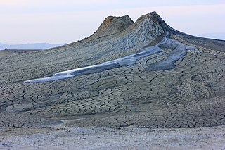
Mud Volcanoes State Nature Reserve or in its full name Mud Volcanoes Group of Baku and Absheron Peninsula State Nature Reserve is a state reserve located in the Absheron region of Azerbaijan. The area of the reserve is 12,322.84 hectares and 43 mud volcanoes are protected here. The world's largest mud volcano Toraghay is also protected in this reserve.
