
Palakkad is one of the 14 districts in the Indian state of Kerala. It was carved out of the southeastern region of the former Malabar District on 1 January 1957. It is located at the central region of Kerala and is the second largest district in the state after Idukki. The city of Palakkad is the district headquarters. Palakkad is bordered on the northwest by the Malappuram district, on the southwest by the Thrissur district, on the northeast by Nilgiris district, and on the east by Coimbatore district of Tamil Nadu. The district is nicknamed "The granary of Kerala". Palakkad is the gateway to Kerala due to the presence of the Palakkad Gap, in the Western Ghats. The 2,383 m high Anginda peak, which is situated in the border of Palakkad district, Nilgiris district, and Malappuram district, in Silent Valley National Park, is the highest point of elevation in Palakkad district. Palakkad city is about 347 kilometres (216 mi) northeast of the state capital, Thiruvananthapuram.
Victor Okechukwu Agali is a Nigerian former professional footballer who played as a forward.

Malampuzha is a town in Palakkad district of Kerala, India. It is located about 3.5 km (2.2 mi) from Malampuzha Dam and 14 km (8.7 mi) from Palakkad city.

Attappadi (HQ:Agali) is a tribal taluk in Kerala state covering an area of 735 km2 (284 sq mi). It was carved out of Mannarkkad taluk in Palakkad district in February 2021. Attappadi Reserve Forest is a protected area comprising 249 km2 of land in the western parts of Attappadi. It is one of the reserved forests and protected forests of India. Attappadi valley in Palakkad district along with the neighbouring Chaliyar valley of the Nilambur region in Malappuram district is known for natural Gold fields which are also seen in the other regions of Nilgiri Biosphere Reserve.

Mannarkkad, formerly known as Mannarghat, is a major municipal town in Palakkad district of the Indian state of Kerala. The Silent Valley National Park and the Attappadi Reserve Forest are located in Mannarkkad Taluk. Mannarkkad is situated 36 km away from district headquarters Palakkad on National Highway 966. It is the traditional seat of the Mannarghat Moopil Nair.

Palakkad, also known as Palghat, historically known as Palakkattussery, is a city and municipality in the Indian state of Kerala. It is the administrative headquarters of Palakkad District. Palakkad is the most densely populated municipality and the fourth-most densely populated city in the state. It was established before Indian independence under British rule and known by the name Palghat. Palakkad is famous for the ancient Palakkad Fort, which is in the heart of the city and was captured and rebuilt by Hyder Ali in 1766 which later fell into the hands of Zamorin in 1784. The city is about 347 kilometres (216 mi) northeast of the state capital, Thiruvananthapuram.
Agali is a mandal in Sri Sathya Sai district of Andhra Pradesh, India. It is about 151 kilometers from Anantapur town and bordered by Karnataka state and Rolla Mandal of Sri Sathya Sai district.
Agali may refer to several places:

Üçüncü Ağalı is a village in the Zangilan District of Azerbaijan.
İkinci Ağalı is a village in the Zangilan District of Azerbaijan.
Kallamala is a village in the Palakkad district, state of Kerala, India. It is administrated by the Agali gram panchayat.
Mannur is a village and gram panchayat in the Palakkad district, state of Kerala, India.

National Highway 966 is a highway which connects Palakkad, Malappuram and Kozhikode district headquarters in Kerala. It was previously known as NH 213. It covers a distance of 125 km. At Ramanattukara, near Kozhikode, it joins NH 66. At Palakkad it joins NH 544, which connects Coimbatore and Cochin through Palakkad. The Palakkad–Malappuram–Kozhikode Greenfield Highway has been proposed in order to decongest the traffic on NH 966 and reduce travelling time between Kozhikode and Palakkad.
Sarang is an alternative school on a hill top started by a teacher couple, Gopalakrishnan and Vijayalakshmi in Agali Panchayath in Attappady, Palakkad district, Kerala, India. The school's curriculum includes organic farming, art forms and environmental conservation among other subjects.

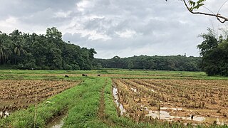
Agali is a village in Palakkad district in the state of Kerala, India. It forms a part of the Agali Grama Panchayat.

Sugarcane Breeding Institute (SBI) is a central research institute in Coimbatore, India. It was established in 1912 and is affiliated to Indian Council of Agricultural Research. It was established to promote research efforts in sugarcane production and is the only sugarcane research institute in the country.

The Kanjirapuzha Dam, a masonry earth dam built for providing irrigation to a Cultural Command Area (CCA) of 9,713 hectares, is located in the Palakkad district in the Indian state of Kerala. The reservoir, which has three islands within it, also has an established commercial fisheries development programme operated by the Fisheries Department.
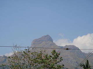
Malleswaran Mudi is the highest peak in the Attappadi Forest Reserve in Attappadi Tribal Taluk, Palakkad district, Kerala, India at an elevation of 1,664 meters. It is located at the Agali Hills range in the Western Ghats.
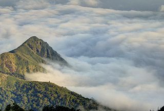
Agali Hills is a small tribal village and hill station in the Palakkad district of Kerala, India. It lies at the base of Malleswaran peak, and is situated in the Attappadi forest reserve, bordering Silent Valley National Park.

