Lasithi is the easternmost regional unit on the island of Crete, to the east of Heraklion. Its capital is Agios Nikolaos, the other major towns being Ierapetra and Sitia. The mountains include the Dikti in the west and the Thrypti in the east. The Sea of Crete lies to the north and the Libyan Sea to the south.

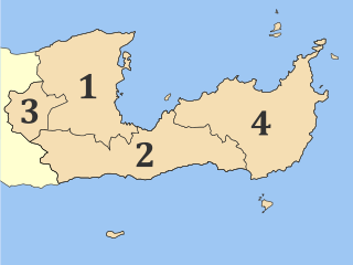
Hersonissos, also transliterated as Chersonissos and Hersónisos, is a town and a local government unit in the north of Crete, bordering the Mediterranean / Aegean Sea. The town is about 25 kilometers east of Heraklion and west of Agios Nikolaos. What is usually called Hersonissos is in fact its peninsula and harbour. It is part of the Heraklion regional unit. It is situated 25 km from the Heraklion airport and 27 km from the Heraklion port. The seat of the local government unit is the village of Gournes.

Voies is a former municipality in Laconia, Peloponnese, Greece. Since the 2011 local government reform it is part of the municipality Monemvasia, of which it is a municipal unit. The municipal unit has an area of 215.527 km2. It is on the southern tip of Cape Malea. It is a predominantly agricultural region with a few minor villages and one dominant town. Vatika is the common term for the area, but Voies is used in a more official context, particularly for postal situations. Voion, the genitive, is used for description: for example, to differentiate the village of Agios Nikolaos in Voies from other villages and towns of the same name, one would use Agios Nikolaos Voion. Neapoli is the administrative capital of the municipality, and is also the urban center to the numerous villages that surround the hinterland.

Sitia or Siteia is a port town and a municipality in Lasithi, Crete, Greece. The town has 11,166 inhabitants and the municipality has 20,438 (2021). It lies east of Agios Nikolaos and northeast of Ierapetra. Sitia's port is on the Sea of Crete, part of the Aegean Sea and is one of the economic centers of the Lasithi region. European route E75 starts in Sitia. The town is served by the Sitia Public Airport. It has not experienced the effects of mass tourism even though there is a long beach along the road leading to Vai and several places of historical interest.

Ierapetra is a Greek city and municipality located on the southeast coast of Crete.

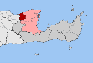
Apokoronas is a municipality and a former province (επαρχία) in the Chania regional unit, north-west Crete, Greece. It is situated on the north coast of Crete, to the east of Chania itself. The seat of the municipality is the village Vryses. The municipality has an area of 315.478 km2 (121.807 sq mi). It has a total of 75 villages.

Sithonia, also known as Longos, is a peninsula and part of the larger peninsula of Chalkidiki in Greece. The Kassandra Peninsula lies to the west of Sithonia and the Mount Athos peninsula to the east. Sithonia is also the name of a municipality, covering the Sithonia Peninsula. The seat of the municipality is the town Nikiti.

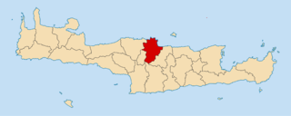
Neapoli is a small town and a former municipality in Lasithi, eastern Crete, Greece. Since the 2011 local government reform, it has been treated as a municipal unit of Agios Nikolaos. The municipal unit has an area of 130.450 km2 (50.367 sq mi). It is located 12 kilometres west from Agios Nikolaos in the green valley of Mirabello. The surrounding area is mountainous and home to a collection of native olive trees. Neapoli is a traditional Cretan town with narrow streets and cobbled roads. The Cathedral of the Virgin Mary is located on the central square.

Rethymno is one of the four regional units of Crete, Greece. Its capital is the city of Rethymno. Today its main income is tourism. The countryside is also based economically on agriculture and herding.
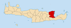
Heraklion is one of the four regional units of Crete. The capital is the city of Heraklion.

Istiaia is a town and a former municipality in Euboea, Greece. It was named after the ancient town Histiaea, which was mentioned by the ancient Greek poet Homer. Since the 2011 local government reform, it has been part of the municipality Istiaia-Aidipsos, of which it is the seat and a municipal unit. The municipal unit has an area of 181.299 km2.

Kissamos is a town and a municipality in the west of the island of Crete, Greece. It is part of the Chania regional unit and of the former Kissamos Province which covers the northwest corner of the island. The town of Kissamos is also known as Kastelli Kissamou and often known simply as Kastelli after the Venetian castle that was there. It is now a port and fishing harbour, with a regular ferry from the Peloponnese via Kythira. A town museum is located in the old Venetian governor's palace and there have been important archaeological finds in the town, including fine mosaics, dating from the Roman city of Kisamos. The head town of the municipality is Kastelli-Kissamos itself.
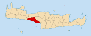
Vrachasi is a village and a former municipality in the Lasithi regional unit, Crete, Greece. Since the 2011 local government reform it is part of the municipality of Agios Nikolaos, of which it is a municipal unit. The municipal unit has an area of 63.41 km2 (24.48 sq mi).

Neapoli–Sykies is a municipality of the Thessaloniki Urban Area in the regional unit of Thessaloniki, Central Macedonia, Greece and part of the Thessaloniki Urban Area. The seat of the municipality is in Sykies. The municipality has an area of 12.903 km2.
Malevizi is a municipality in Heraklion regional unit, Crete, Greece. The seat of the municipality is the town of Gazi. The municipality has an area of 291.907 km2 (112.706 sq mi).

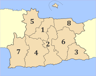
Amari is a village and a municipality in Rethymno regional unit, Crete, Greece. The seat of the municipality is the village Agia Foteini. The municipal unit has an area of 277.285 km2 (107.060 sq mi). One of the major geographic features of Amari is the Amari Valley, a landform of high elevation known for olive cultivation. It is thought that Monastiraki was developed by Phaistos inhabitants founding a satellite center as they pushed out into the Amari Valley.
Agios Vasileios is a village and a municipality in Rethymno regional unit, Crete, Greece. The seat of the municipality is the village Spili. The municipality has an area of 359.171 km2 (138.677 sq mi).

Mylopotamos is a municipality in Rethymno regional unit, on Crete, southern Greece. The seat of the municipality is the village Perama. The municipal unit has an area of 360.703 km2 (139.268 sq mi).

Voio is a municipality in the Kozani regional unit, Greece. The seat of the municipality is the town Siatista. It was named after the Voio mountains. The municipality has an area of 1007.629 km2. Its population at the 2021 census was 14,947.

The Municipality of Rethymno is a municipality in the Rethymno of the region of Crete established by Kallikratis reform. It consists of the unification of the pre-existing municipalities Arkadi, Lappa, Rethymno and Nikiforos Fokas of Rethymno Prefecture. The extent of the new municipality is 396.256 km2 (152.995 sq mi), and it had a population of 57,216 inhabitants at the 2021 census. The seat of the new municipality is the town Rethymno.