Agnes Banks Natural Area

Last updated

Agnes Banks Natural Area
Location map Australia Sydney.png
Red pog.svg
Location of Agnes Banks Natural Area in Sydney
LocationRickards Avenue, Agnes Banks, City of Penrith, New South Wales, Australia
Coordinates 33°38′27″S150°41′57″E / 33.6408°S 150.6992°E / -33.6408; 150.6992
Owner CSR Limited; Office of Environment and Heritage
Official nameNatural Area; The Natural Area; Agnes Banks Sand Deposits
TypeState heritage (landscape)
Designated2 April 1999
Reference no.649
TypeSoil site
CategoryLandscape - Natural

The Agnes Banks Natural Area is a heritage-listed natural sand deposit, fauna habitat and native flora site at Rickards Avenue in the western Sydney suburb of Agnes Banks, New South Wales, Australia. It is also known as The Natural Area and Agnes Banks Sand Deposits. The property is owned by CSR Limited and the NSW Office of Environment and Heritage. It was added to the New South Wales State Heritage Register on 2 April 1999. [1]

Contents

History

The Londonderry/Agnes Banks sand deposit was first recognised for its commercial potential in 1942. Sand had been extracted from the deposit for over thirty years, initially under consent from the then Cumberland County Council. Penrith City Council first issued consents in 1967 for the extraction of sand from land held under permissive occupancies from the Crown Lands Office and from land held under private tenure. [1]

Penrith Council later realised the need for an overall management framework for the extractive industries and during the mid-1970s formed a working committee consisting of Council, the then Department of Mines, Department of Lands and the extractive industry companies. This committee sought information and produced guidelines for co-ordinating ongoing extraction and rehabilitation within a defined management area. In 1982 after extensive consultation with the community in the locality, sand extraction companies and government agencies, Council adopted in principle the management plan, which, inter alia, addressed management of extraction, drainage, staged extraction and rehabilitation. Regular meetings of the parties were held to ensure compliance with the plan. [1]

Comments received from the NSW National Parks & Wildlife Service (NPWS) at the time indicated the Service's concern for the inter-relationships between sand extraction and the proposed nature reserve to the south of the management area. As a consequence provision was made for a 30-metre (98 ft) wide buffer strip between areas designated for extraction and the nature reserve. [1]

The nature reserve proposal involved lengthy discussion with government agencies, Council and the extractive industry companies. The proposal was initiated by the Scientific Committee on Parks and Reserves in August 1968. This committee had advised of the scientific value and uniqueness of the sand areas and of the threat to them posed by sand extraction. In the following years several proposals were advanced by the NPWS and by Benson of the National Herbarium, Royal Botanic Gardens. Negotiations between the parties continued until a compromise proposal put forward in 1978 by White of P. B. White Minerals (now Pacific Mining Pty. Ltd.) was finally accepted. However the NPWS although accepting the proposal, noted in correspondence to the Department of Lands at the time that the proposal was sub-optimal in area and composition. The Agnes Banks Nature Reserve was proclaimed on 26 March 1982. [1]

On the 18 April 1985 two development applications were received by Council which in part were for consent to extract sand adjacent to the Agnes Banks Nature Reserve. [1]

The National Trust of Australia (NSW) wrote to Penrith City Council on 23 August 1985 indicating its proposal for the extension of the Nature Reserve to ensure it properly sampled the range of plant communities on the site. On the 26 August 1985, the Trust wrote to the Heritage Council requesting the placing of an interim conservation order (ICO) on the remaining areas of vegetation outside the Nature Reserve. ICO No. 569 was gazetted on 27 September 1985 for a period of two years subsequently ICO No. 800 was gazetted on 18 September 1987. [1] In August, 1987, The Readymix Group, Amatek Limited and K. H. Dixon Pty. Ltd. made a submission by way of objection to the former Minister for Planning and Environment in regard to ICO No. 569. Formal objections to the making of ICO No. 800 dated 5 February 1988 were subsequently received by the Heritage Council. [1] Commissioner Kevin Cleland was appointed to hold an inquiry into the submission by of objection on 25 July 1988 in accordance with Section of the Heritage Act, 1977. [1] A total of twenty seven submissions were received of which fourteen were presented to the inquiry and a further six were read on behalf of the writers. The Companies, Department of Mineral Resources and Department of Lands objected to the making of the ICO. The majority of the other submissions supported the making of a Permanent Conservation Order. Several submissions related to other matters. [2] [1]

Further information

The Agnes Banks Natural Area adjoins the Agnes Banks Nature Reserve [3] created in March 1982. The 123-hectare (300-acre) nature reserve is managed by the National Parks and Wildlife Service. [1] [4]

Heritage listing

As at 25 January 2013, the Agnes Banks Natural Area is of State Heritage significance for its environmental heritage with natural, scientific and aesthetic significance for the following reasons: [1]

Importance in the evolution of Australian flora, fauna, landscapes and climate

The "Agnes Banks Sand" is described as a stratigraphic unit of Pliocene of Pleistocene age (7 million-300,000 years ago) and probably a fluvial deposit which has been redistributed by westerly winds. The sands are surrounded by and overlie lateritized tertiary alluvial deposits, mainly clay and silts which make up the Cumberland Plain to the south and east. The sand deposit is unique in that although it is 55 kilometres (34 mi) from the present coast, it supports unusual vegetation in many ways similar to coastal sand dune vegetation such as Myall Lakes, and with affinities also to Hawkesbury sandstone vegetation which is located in the Sydney Basin. The deposits themselves are highly important scientifically: as a reference site for understanding the past climatic history of the region; and, for comparison of the vegetation with similar vegetation on coastal sand deposits. The sediment making up the deposit originates from sandstone rock of the Blue Mountains and as such demonstrates the evolutionary process of weathering and deposition. [1]

Importance in demonstrating existing processes or natural systems

The Agnes Banks Natural Area supports four distinct associations. These are described as: [1]

  1. Low open forest of Banksia serrata and Angophora bakeri which is confined to the well-drained crests of the large dunes;
  2. Woodland of Eucalyptus sclerophylla , A. bakeri and B. serrata on well-drained and moderately well-drained positions;
  3. Woodland of E. sclerophylla, E. parramattensis and B. aemula on shallow sand; and
  4. Low-open Woodland of E. parramattensis which is confined to poorly-drained situations. [1]

Studies by the National Herbarium, Royal Botanic Gardens indicate that species distribution is dominated primarily by a moisture drainage factor which produces a continuum of species. Projective' canopy cover and fire also influence the distribution of the vegetation. The relationship between these environmental factors and vegetation communities is clearly demonstrated at the Agnes Banks Natural Area. [1]

Importance in exhibiting unusual richness or diversity of flora

The diversity of soil types and conditions has given rise to a corresponding diversity of vegetation types as indicated above. [1]

Importance for rare and endangered or uncommon flora, communities, ecosystems and landscape

As described in I above, the sand deposits at Agnes Banks are an unusual and rare landform which, in conjunction with vegetation cover, results in a rare landscape type. Areas of original vegetation on the sand deposits associated with the Hawkesbury-Nepean rivers are extremely limited. The area is thus significant as a unique sample of this vegetation, which is otherwise not conserved. The Natural Area support several species which are considered rare or threatened, being represented by small populations, disjunct populations, or being at or near their geographic limits. These include the following: [1]

The whole community, with associations relating intergrading with each other, in this isolated inland position, at a low elevation are unique. Likewise is the ecosystem mechanics which operate and determine the species distribution. [1]

Importance as representative of the range of ecosystems which characterise sand vegetation type

More than half of the original sand area of 460 hectares (1,100 acres) (sic.) at Agnes Banks has been cleared or quarried. Only two of the five plant communities recognised on the sand are represented in the existing Nature Reserve. Of the Reserve's 64 hectares (160 acres) only 16 hectares (40 acres) or 3.5 per cent (sic.) of the original sand mass is conserved. One of the plant communities - sedgeland - has now been completely destroyed through sand mining operations. The current Agnes Bank Reserve does not sample any Low Open Forest Banksia Serrata and Angophora Bakeri or Woodland E. Sclerophylla, Banksia Serrata and Angophora Baker plant associations. The only other known occurrence of B. Serrata in the general area is a tiny stand on freehold land which is badly damaged. Furthermore, the Agnes Banks Natural Area supports other species, namely Persoonia nutans, and Petrophile sessilis, which are not adequately conserved. This inadequate representation of the variation in the system limits the scope of the area for scientific research. [1]

Importance for information contributing to wider understanding of Australian natural history

By virtue of their use as research sites, teaching sites, type localities and reference sites: [1]

  1. the isolated location of the deposit makes it suitable for biogeographical studies;
  2. the relationship with the surrounding/underlying clay is of interest as is the internal dynamics controlled by soil water status and fire frequency;
  3. the distinct change in vegetation at the sandclay interface;
  4. the B. aemula/B. serrata interface/hybrid swarm presents a good opportunity for population genetics/autoecological studies;
  5. the complex ecotone between plant association of Woodland and Low Woodland;
  6. the site is unusual in geomorphological terms; and
  7. the sands are important as a soil reference site. [1]

Furthermore, as environmental education is a component of school curriculum, the demand for areas such as Agnes Banks for field studies, is great. [5] [1]

Aboriginal sites already identified at Agnes Banks are believed to date to about 13,000 years ago. Open sites of this age are rare in eastern New South Wales. It is possible that older sites are situated within or under the sand. Agnes Banks may prove to be a significant source of information about human occupation during the late Pleistocene period. [1]

The Agnes Bank Natural Area was listed on the New South Wales State Heritage Register on 2 April 1999. [1]

See also

Related Research Articles

<span class="mw-page-title-main">Kamay Botany Bay National Park</span> Protected area in New South Wales, Australia

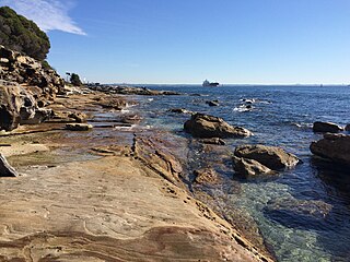
The Kamay Botany Bay National Park is a heritage-listed protected national park that is located in the eastern part of Botany Bay in Sydney, New South Wales, Australia. The 456-hectare (1,130-acre) national park is situated approximately 16 kilometres (9.9 mi) south-east of the Sydney central business district, on the northern and southern headlands of Botany Bay. The northern headland is at La Perouse and the southern headland is at Kurnell.

<span class="mw-page-title-main">Royal National Park</span> Protected area in New South Wales, Australia

The Royal National Park is a protected national park that is located in Sutherland Shire local government area in the southern portion of Sydney, New South Wales, Australia.

<span class="mw-page-title-main">Beecroft Peninsula</span>

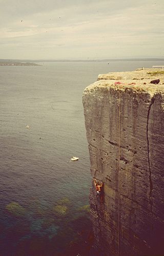
Beecroft Peninsula is the northern headland of Jervis Bay, on Australia's east coast. On the western and southern sides of the peninsula steep sandstone cliffs rise out of the ocean, up to 91 metres at its southernmost point, Point Perpendicular. White sandy beaches are found along the northern, eastern and southern sides interspersed with numerous intertidal reefs.

<i>Banksia serrata</i> Species of tree native to eastern Australia

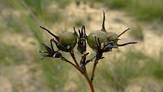
Banksia serrata, commonly known as the saw banksia, the old man banksia, the saw-tooth banksia or the red honeysuckle and as wiriyagan by the Cadigal people, is a species of woody shrub or tree of the genus Banksia, in the family Proteaceae. Native to the east coast of Australia, it is found from Queensland to Victoria with outlying populations on Tasmania and Flinders Island. Commonly growing as a gnarled tree up to 16 m (50 ft) in height, it can be much smaller in more exposed areas. This Banksia species has wrinkled grey bark, shiny dark green serrated leaves and large yellow or greyish-yellow flower spikes appearing over summer. The flower spikes, or inflorescences, turn grey as they age and pollinated flowers develop into large, grey, woody seed pods called follicles.

<i>Banksia aemula</i> Shrub of the family Proteaceae found on the Australian east coast

Banksia aemula, commonly known as the wallum banksia, is a shrub of the family Proteaceae. Found from Bundaberg south to Sydney on the Australian east coast, it is encountered as a shrub or a tree to 8 m (26 ft) in coastal heath on deep sandy soil, known as Wallum. It has wrinkled orange bark and shiny green serrated leaves, with green-yellow flower spikes, known as inflorescences, appearing in autumn. The flower spikes turn grey as they age and large grey follicles appear. Banksia aemula resprouts from its woody base, known as a lignotuber, after bushfires.

<i>Banksia oblongifolia</i> Species of plant

Banksia oblongifolia, commonly known as the fern-leaved, dwarf or rusty banksia, is a species in the plant genus Banksia. Found along the eastern coast of Australia from Wollongong, New South Wales in the south to Rockhampton, Queensland in the north, it generally grows in sandy soils in heath, open forest or swamp margins and wet areas. A many-stemmed shrub up to 3 m (9.8 ft) high, it has leathery serrated leaves and rusty-coloured new growth. The yellow flower spikes, known as inflorescences, most commonly appear in autumn and early winter. Up to 80 follicles, or seed pods, develop on the spikes after flowering. Banksia oblongifolia resprouts from its woody lignotuber after bushfires, and the seed pods open and release seed when burnt, the seed germinating and growing on burnt ground. Some plants grow between fires from seed shed spontaneously.

<span class="mw-page-title-main">Malabar Headland</span> Historic site in New South Wales, Australia

The Malabar Headland is a heritage-listed former public recreation area and military installation site and now nature conservation and public recreation headland area located at Franklin Street, Malabar in the City of Randwick local government area of New South Wales, Australia. It is also known as Long Bay Rifle Range, Anzac Rifle Range and Boora Point. The property is owned by the New South Wales Government. It was added to the New South Wales State Heritage Register on 22 July 2005.

<span class="mw-page-title-main">Yathong Nature Reserve</span> Protected area in New South Wales, Australia

The Yathong Nature Reserve is a protected nature reserve that is also a nationally and internationally recognized biosphere situated in the central-western region of New South Wales, in eastern Australia. The 107,240-hectare (265,000-acre) reserve was listed by UNESCO in 1977 as a Biosphere Reserve under the Man and the Biosphere Programme (MAB). The reserve is significant for its biodiversity in both native plant and animal species. Cultural heritage and historical grazing activities add to the significance of this site as a conservation area.

The Castlereagh Nature Reserve is a protected nature reserve located in the western suburbs of Sydney in New South Wales, Australia. The 495-hectare (1,220-acre) reserve is situated 60 kilometres (37 mi) west of the central business district, approximately 10 kilometres (6.2 mi) north-east of Penrith and located near the townships of Castlereagh and Londonderry. In 1960, 266 hectares was reclaimed for use as a Child Welfare Training School, and in 1971, 389 hectares was reclaimed for the establishment of a liquid waste disposal facility.

<i>Haemodorum corymbosum</i> Species of flowering plant

Haemodorum corymbosum, commonly known as the rush-leaf bloodroot, is a shrub native to southeastern Australia. Danish-Norwegian naturalist Martin Vahl described this species in his 1805 work Enumeratio Plantarum.

<span class="mw-page-title-main">Caravan Head Bushland Reserve</span> Nature reserve in Sydney, Australia

Caravan Head Bushland Reserve is a reserve approximately 2.2ha located in Sutherland Shire, southern Sydney, in the state of New South Wales, Australia.

<span class="mw-page-title-main">Joseph Banks Native Plants Reserve</span> Botanical garden in Sydney, NSW

Joseph Banks Native Plants Reserve is one of the few specialised gardens in Sydney to focus entirely on Australian native plants. Located at Kareela in Sutherland Shire and established in 1970 as a tribute to Joseph Banks, the landscaped garden covers an area of 2.2 hectares, with 4 kilometres of sealed paths.

<span class="mw-page-title-main">Sydney Sandstone Ridgetop Woodland</span> Indigenous forest communities of Sydney, Australia

The Sydney Sandstone Ridgetop Woodland, also known as Coastal Sandstone Ridgetop Woodland and Hornsby Enriched Sandstone Exposed Woodland, is a shrubby woodland and mallee community situated in northern parts of Sydney, Australia, where it is found predominantly on ridgetops and slopes of the Hornsby Plateau, Woronora Plateau and the lower Blue Mountains area. It is an area of high biodiversity, existing on poor sandstone soils, with regular wildfires, and moderate rainfall.

<span class="mw-page-title-main">Prospect Nature Reserve</span>

Prospect Nature Reserve is a nature reserve and recreational area that is situated in the western suburbs of Sydney, New South Wales, Australia, which incorporates the Prospect Reservoir, and also features picnic spots, lookouts, walking tracks and BBQ areas within the Australian bush. It is located within the Blacktown City local government area, but is also close to the boundaries of Cumberland Council and the City of Fairfield.

<span class="mw-page-title-main">Ecology of Sydney</span> Geographic aspect of Sydney, Australia

The ecology of Sydney, located in the state of New South Wales, Australia, is diverse for its size, where it would mainly feature biomes such as grassy woodlands or savannas and some sclerophyll forests, with some pockets of mallee shrublands, riparian forests, heathlands, and wetlands, in addition to small temperate rainforest fragments.

Wide Bay Military Reserve is a heritage-listed military installation at Tin Can Bay Road, Tin Can Bay, Queensland, Australia. The reserve supports a diverse range of plant communities from estuarine, strand, wetlands, heath, tall shrublands and woodlands, to the open forests of the sub-coastal hills and ranges. The total number of bird species recorded for the place totals 250, which is high by Australian standards. It was added to the Australian Commonwealth Heritage List on 22 June 2004.

<span class="mw-page-title-main">Central Hunter Valley eucalypt forest and woodland</span> Endangered ecological community

The Central Hunter Valley eucalypt forest and woodland is a grassy woodland community situated in the Hunter Valley, New South Wales, Australia. It was listed in May 2015 as critically endangered under Australia's national environment law. The Warkworth Sands Woodland of the Hunter Valley, situated in the area, was gazetted as an endangered ecological community in New South Wales on 13 December 2002 under the NSW Threatened Species Conservation Act 1995 and now under the Biodiversity Act of 2016.

<span class="mw-page-title-main">Elderslie Banksia Scrub Forest</span> Indigenous woodland community in Sydney, Australia

The Elderslie Banksia Scrub Forest is a critically endangered scrubby woodland situated in southwestern Sydney, New South Wales, Australia. Listed under the Environment Protection and Biodiversity Conservation Act 1999, it is a variety of stunted forest or woodland found on sandy substrates associated with deep Tertiary sand deposits, which has been reduced in extent of at least 90% of its original pre-European extent.

<span class="mw-page-title-main">Eastern Suburbs Banksia Scrub</span> Indigenous woodland community in Sydney, Australia

The Eastern Suburbs Banksia Scrub, which also incorporates Sydney Coastal Heaths, is a remnant sclerophyll scrubland and heathland that is found in the eastern and southern regions of Sydney, New South Wales, Australia. Listed under the Environment Protection and Biodiversity Conservation Act 1999 as and endangered vegetation community and as 'critically endangered' under the NSW Biodiversity Conservation Act 2016, the Eastern Suburbs Banksia Scrub is found on ancient, nutrient poor sands either on dunes or on promontories. Sydney coastal heaths are a scrubby heathland found on exposed coastal sandstone plateau in the south.

<span class="mw-page-title-main">Castlereagh Scribbly Gum and Agnes Banks Woodlands</span> Indigenous woodland community in Sydney, Australia

The Castlereagh Scribbly Gum and Agnes Banks Woodlands is an endangered sclerophyll low-woodland and shrubland community found in western Sydney, New South Wales, Australia. Vegetation comprises low woodlands with sclerophyllous shrubs and an uneven ground layer of graminoids and forbs.

References

  1. 1 2 3 4 5 6 7 8 9 10 11 12 13 14 15 16 17 18 19 20 21 22 23 24 25 26 "Natural Area". New South Wales State Heritage Register . Department of Planning & Environment. H00649. Retrieved 13 October 2018. CC BY icon.svg Text is licensed by State of New South Wales (Department of Planning and Environment) under CC-BY 4.0 licence .
  2. Cleland 1988
  3. "Agnes Banks Nature Reserve". Geographical Names Register (GNR) of NSW. Geographical Names Board of New South Wales . Retrieved 4 February 2018. OOjs UI icon edit-ltr-progressive.svg
  4. "Agnes Banks Nature Reserve". NSW National Parks & Wildlife Service . Government of New South Wales. 2019. Archived from the original on 4 February 2019. Retrieved 4 February 2019.
  5. Heritage Council Submission to Commission of Inquiry, 1988

Bibliography

Attribution

CC BY icon-80x15.png This Wikipedia article was originally based on Agnes Banks Natural Area , entry number 649 in the New South Wales State Heritage Register published by the State of New South Wales (Department of Planning and Environment) 2018 under CC-BY 4.0 licence , accessed on 13 October 2018.