
The Gulf Coast of the United States is the coastline along the Southern United States where they meet the Gulf of Mexico. The coastal states that have a shoreline on the Gulf of Mexico are Texas, Louisiana, Mississippi, Alabama, and Florida, and these are known as the Gulf States.

The Rio Grande is one of the principal rivers in the southwestern United States and northern Mexico. The Rio Grande begins in south-central Colorado in the United States and flows to the Gulf of Mexico. After passing through the length of New Mexico along the way, it forms part of the Mexico–United States border. According to the International Boundary and Water Commission, its total length was 1,896 miles (3,051 km) in the late 1980s, though course shifts occasionally result in length changes. Depending on how it is measured, the Rio Grande is either the fourth- or fifth-longest river system in North America.

Gulf Oil was a major global oil company from 1901 until March 15, 1985. The eighth-largest American manufacturing company in 1941 and the ninth-largest in 1979, Gulf Oil was one of the so-called Seven Sisters oil companies. Prior to its merger with Standard Oil of California, Gulf was one of the chief instruments of the Mellon family fortune; both Gulf and Mellon Financial had their headquarters in Pittsburgh.

The Gulf Coast League is a rookie-level Minor League Baseball league that operates in Florida, United States. Together with the Arizona League, it forms the lowest rung on the North American minor-league ladder. GCL teams play at the minor league spring training complexes of their parent Major League Baseball clubs and are owned by those parent clubs. Admission is not charged and no concessions are operated at the teams' games.
Interstate 45 (I-45) is a major Interstate Highway located entirely within the U.S. state of Texas. While most Interstate routes which have numbers ending in "5" are cross-country north-south routes, I-45 is comparatively short, with the entire route located in Texas. It connects the cities of Dallas and Houston, continuing southeast from Houston to Galveston over the Galveston Causeway to the Gulf of Mexico.
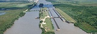
The Gulf Intracoastal Waterway is the portion of the Intracoastal Waterway located along the Gulf Coast of the United States. It is a navigable inland waterway running approximately 1,050 mi (1,690 km) from Carrabelle, Florida, to Brownsville, Texas.

Sabine Lake is a bay on the Gulf coasts of Texas and Louisiana, located approximately 90 miles (140 km) east of Houston and 160 miles (260 km) west of Baton Rouge, adjoining the city of Port Arthur. The lake is formed by the confluence of the Neches and Sabine Rivers and connects to the Gulf of Mexico through Sabine Pass. It forms part of the Texas–Louisiana border, falling within Jefferson and Orange Counties in Texas and Cameron Parish, Louisiana.

Southeast Texas is a sub-region of East Texas. It is geographically centered on the Greater Houston and Beaumont–Port Arthur metropolitan areas.
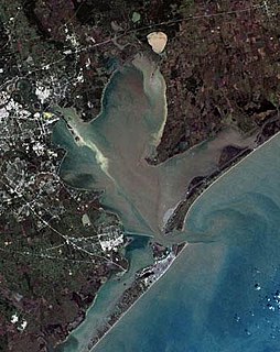
Galveston Bay is a bay in the western Gulf of Mexico along the upper coast of Texas. It is the seventh-largest estuary in the United States, and the largest of seven major estuaries along the Texas Gulf Coast. It is connected to the Gulf of Mexico and is surrounded by sub-tropical marshes and prairies on the mainland. The water in the bay is a complex mixture of sea water and fresh water, which supports a wide variety of marine life. With a maximum depth of about 10 feet (3 m) and an average depth of only 6 feet (2 m), it is unusually shallow for its size.

Matagorda Bay is a large Gulf of Mexico bay on the Texas coast, lying in Calhoun and Matagorda counties and located approximately 80 miles (130 km) northeast of Corpus Christi, 143 miles (230 km) east-southeast of San Antonio, 108 miles (174 km) south-southwest of Houston, and 167 miles (269 km) south-southeast of Austin. It is one of seven major estuaries along the Gulf Coast of Texas and serves as the mouth of numerous streams, most notably the Lavaca and Colorado Rivers. The Texas seaport of Port Lavaca is located on the system's northwestern extension of Lavaca Bay. The city of Palacios is found on northeastern extension of Tres Palacios Bay, and Port O'Connor is located on the southwestern tip of the main bay's shore. The ghost town of Indianola, which was a major port before it was destroyed by two hurricanes in the late 19th century, is also found on the bay.

South Texas is a region of the U.S. state of Texas that lies roughly south of—and including—San Antonio. The southern and western boundary is the Rio Grande, and to the east it is the Gulf of Mexico. The population of this region is about 4.96 million according to the 2017 census estimates. The southern portion of this region is often referred to as the Rio Grande Valley. The eastern portion along the Gulf of Mexico is also referred to as the Coastal Bend.

The 2004 Christmas Eve United States winter storm was a rare weather event that took place in Louisiana and Texas in the United States on December 24, 2004, before the storm moved northeast to affect the coastal sections of the Mid-Atlantic states and New England in the succeeding few days. This was a different storm from the historic event that struck the Midwest and southern Canada around December 23 from another cyclone which preceded this storm. The event involved a thin band of snowfall with unusually cold temperatures for the middle Texas coast, and caused dozens of varied weather records to be shattered. It was the most significant snow for the Texas Gulf Coast, and deep South Texas, since February 1895.

The Gulf Cartel is a criminal syndicate and drug trafficking organization in Mexico, and perhaps one of the oldest organized crime groups in the country. It is currently based in Matamoros, Tamaulipas, directly across the U.S. border from Brownsville, Texas.

The geography of Texas is diverse and large. Occupying about 7% of the total water and land area of the U.S., it is the second largest state after Alaska, and is the southernmost part of the Great Plains, which end in the south against the folded Sierra Madre Oriental of Mexico. Texas is in the South Central United States of America, and is considered to form part of the U.S. South and also part of the U.S. Southwest.

Texas' weather varies widely, from arid in the west to humid in the east. The huge expanse of Texas encompasses several regions with distinctly different climates: Northern Plains, Trans-Pecos Region, Texas Hill Country, Piney Woods, and South Texas. Generally speaking, the part of Texas that lies to the east of Interstate 35 is subtropical, while the portion that lies to the west of Interstate 35 is arid desert.

The Gulf of Mexico is an ocean basin and a marginal sea of the Atlantic Ocean, largely surrounded by the North American continent. It is bounded on the northeast, north and northwest by the Gulf Coast of the United States; on the southwest and south by the Mexican states of Tamaulipas, Veracruz, Tabasco, Campeche, Yucatan, and Quintana Roo; and on the southeast by Cuba. The US states of Texas, Louisiana, Mississippi, Alabama, and Florida, which border the Gulf on the north, are often referred to as the "Third Coast" of the United States.
Chartered on June 6, 1903, the St. Louis, Brownsville & Mexico Railway was a 200-mile (321 km) U.S. railroad that operated from Brownsville, Texas, to Gulf Coast Junction in Houston, Texas. It served numerous towns and cities along its routes and operated a rail bridge between Brownsville and Matamoros, Tamaulipas, in junction with the Mexican government. The Brownie connected the citizens of Brownsville to nearby Corpus Christi for the first time on land rather than using water transportation.
The San Antonio and Aransas Pass Railway first began operation in the U.S. state of Texas in 1886. It was developed by Uriah Lott and businessmen of San Antonio as a direct route from the city to Aransas Bay on the Texas Gulf coast. It was eventually absorbed in the 20th century by Southern Pacific.
The Chicago, Rock Island and Gulf Railway was a Texas subsidiary of the Chicago, Rock Island and Pacific Railroad.

Central Texas Lobos is a central Texas team operating in the Gulf Coast Premier League, a USASA-affiliated league. The Lobos' regular kit colors are purple, gold, and black. The Lobos are based in Austin, Texas and play home games in the nearby town of Buda, Texas.