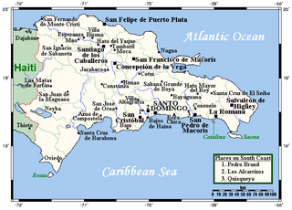
The Dominican Republic is a country in the West Indies that occupies the eastern five-eighths of Hispaniola. It has an area of 48,670 km², including offshore islands. The land border shared with Haiti, which occupies the western three-eighths of the island, is 376 km long. The maximum length, east to west, is 390 km from Punta de Agua to Las Lajas, on the border with Haiti. The maximum width, north to south, is 265 km from Cape Isabela to Cape Beata. The capital, Santo Domingo, is located on the south coast.

The geography of Puerto Rico consists of an archipelago located between the Caribbean Sea and the North Atlantic Ocean, east of the Dominican Republic, west of the Virgin Islands and north of Venezuela. The main island of Puerto Rico is the smallest and most eastern of the Greater Antilles. With an area of 3,515 square miles (9,104 km2), it is the third largest island in the United States and the 82nd largest island in the world. Various smaller islands and cays, including Vieques, Culebra, Mona, Desecheo, and Caja de Muertos comprise the remainder of the archipelago with only Culebra and Vieques being inhabited year-round. Mona is uninhabited through large parts of the year except for employees of the Puerto Rico Department of Natural Resources.
Transport in Venezuela revolves around a system of highways and airports. Venezuela is connected to the world primarily via air and sea. In the south and east the Amazon rainforest region has limited cross-border transport; in the west, there is a mountainous border of over 1,375 miles (2,213 km) shared with Colombia. The Orinoco River is navigable by oceangoing vessels up to 400 km inland, and connects the major industrial city of Ciudad Guayana to the Atlantic Ocean.

Aragua State is located in the north-central region of Venezuela. It has plains and jungles and Caribbean beaches. The most popular are Cata and Choroni. It has Venezuela's first national park which is called Henri Pittier.

Carabobo State is one of the 23 states of Venezuela, located in the north of the country, about two hours by car from Caracas. The capital city of this state is Valencia, which is also the country's main industrial center. The state's area is 4,369 km2 (1,687 sq mi) and as of the 2011 census, had a population of 2,245,744.

Aguas Buenas, commonly known as "La Ciudad de las Aguas Claras" or "The City of Clear (Good) Waters", is a municipality of Puerto Rico (U.S.) located in the Central Mountain Range, north of Cidra, south of Bayamón, Guaynabo and San Juan; east of Comerio; and north-west of Caguas. Aguas Buenas is spread over 9 wards and Aguas Buenas Pueblo. It is part of the San Juan-Caguas-Guaynabo Metropolitan Statistical Area.

Municipalities of Venezuela are subdivisions of the States of Venezuela. There are 335 municipalities dividing the 23 states and the Capital District.

The State Railways Institution is a state-run organization of Venezuela that manages the railway systems of the country. Its headquarters are located in Caracas, Venezuela.

Puyehue National Park is located in the Andes mountain range, in Los Ríos and Los Lagos regions of Chile formerly referred to as the 10th region. The park boast 220,000 acres of natural thermal springs, volcanoes, and evergreen forests, after having been expanded in 1950 and 1981. The park is Chile's most visited national park with 400,000 people enjoying it each year. Puyehue National park forms part of the Reserve of Temperate Rainy Forest Biospheres of the Southern Andes. Chile Route 215 passes through the park, which connects with the Argentine Route 231 via Cardenal Antonio Samoré Pass.

Juan Domingo de Monteverde y Rivas, commonly known as Domingo de Monteverde, was a Spanish soldier, governor and Captain General of Venezuela from June 1812 to 8 August 1813. Monteverde was the leader of Spanish forces in the Venezuelan War of Independence from 1812 to 1813. Monteverde led the military campaign that culminated in the fall of the First Republic of Venezuela in 1812. One year later in 1813, Monteverde was defeated by Simón Bolívar during the Admirable Campaign.

The Naguanagua municipality is one of the 14 municipalities (municipios) that makes up the Venezuelan state of Carabobo and, according to the 2011 census by the National Institute of Statistics of Venezuela, the municipality has a population of 157,437. The town of Naguanagua is the shire town of the Naguanagua Municipality. It forms part of the greater Valencia Metropolitan Area in Venezuela. It is in the valley of the Cabriales River at the base of Cerro El Café and the El Trigal Mountain. Valencia and Naguanagua form a continuous urban area. The highway that runs from the centre of Valencia towards Puerto Cabello passes through this community; Bolivar Avenue in Valencia becomes University Avenue in Naguanagua on the northern side of a traffic roundabout, or redoma.
Mariara is a city in Carabobo State, Venezuela, the shire town of the Diego Ibarra Municipality. It was founded by bishop Mariano Marti on 3 December 1781.

The San Esteban National Park is located in Carabobo, Venezuela.

Río Pastillo is a river in the municipality of Ponce, Puerto Rico. It is also known as Río Marueño in the area of the municipality where it runs through barrio Marueño. Together with Cañas River, Pastillo forms Matilde River. Pastillo is one of the 14 rivers in the municipality. The river originates at an altitude of 435 feet. Its tributaries are Quebrada Limon and Quebrada del Agua brooks and the river runs for 19 kilometers before feeding into Río Matilde at a height of 15 feet in Barrio Canas Urbano.

Tourism in Venezuela has been developed considerably for decades, particularly because of its geographical position, the variety of landscapes, the richness of plant and wildlife, the artistic expressions and the privileged tropical climate of the country, which affords each region throughout the year. Since 2013 the country is having a very severe economic and political crisis affecting tourism all over the country.

The Camoruco railway terminus in Valencia, Venezuela, is a rare survival of a 19th century railway station in the South America country. The building is also known as the Rectorado of the University of Carabobo. When the railway line closed in the 1950s, the station was transferred to the University of Carabobo which converted it for administrative use.
The Puerto Cabello and Valencia railway is a defunct railway in Venezuela. The 55 km railway was constructed in the 1880s to link Valencia, then the country's second city, with the Caribbean port of Puerto Cabello. It closed in the 1950s.

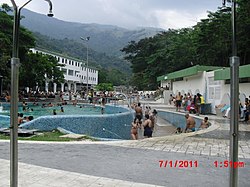
Las Trincheras, also known as Las Trincheras de Aguas Calientes, is a locality near Valencia, Venezuela. It is noted for its hot springs. The name Trincheras is said to derive from fortifications constructed in the colonial era.
Aguas Calientes is the name of a small river in Benítez Municipality, Sucre state, Venezuela. It is fed by hot springs of which there are a number on the Paria Peninsula.