Las Trincheras

Last updated
Las Trincheras
Las Trincheras, Carabobo, Venezuela - panoramio.jpg
The spa at Las Trincheras
Venezuela location map (+claimed).svg
Red pog.svg
Las Trincheras
Coordinates: 10°18′N68°04′W / 10.300°N 68.067°W / 10.300; -68.067 Coordinates: 10°18′N68°04′W / 10.300°N 68.067°W / 10.300; -68.067
Country Flag of Venezuela.svg  Venezuela
State Carabobo
Municipality Naguanagua Municipality
Time zone UTC−4 (VST)

Las Trincheras, also known as Las Trincheras de Aguas Calientes, is a locality near Valencia, Venezuela. It is noted for its hot springs, which feed into the Aguas Calientes River.

Contents

The name Trincheras (Spanish for "trenches") is said to derive from fortifications constructed in the colonial era. [1]

History

Visit of Humboldt

The springs were visited by Alexander von Humboldt in 1800 during his expedition to the American tropics. [2] They were known to the locals and Humboldt noticed that sick people were taking steam baths there.

On his return to Europe, Humboldt made Las Trincheras known to science. He had recorded the temperature of the water as 90.3 °C (194.5 °F). There was no evidence of vulcanism in the area to explain what was heating the water. The work of François Arago on the geothermal gradient helped Humboldt to develop the idea that the springs obtained their heat from very deep groundwater circulation. [3]

Battle of Las Trincheras

Las Trincheras is also noted for a battle which took place in October 1813 during the Venezuelan War of Independence. The Spanish commander Juan Domingo de Monteverde was wounded in the battle which was won by the Independentist forces. [1] The Spanish retreated to their base at Puerto Cabello.

Railway infrastructure

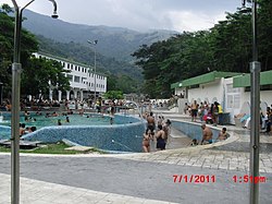
The development of the springs as a resort ( balneario in Spanish) was given a boost by the arrival of the Puerto Cabello and Valencia railway in the 1880s. A station was opened at Las Trincheras, [4] but the railway closed in the 1950s as road transport became more important in Venezuela.

In the 21st century a new railway is being built connecting Puerto Cabello to La Encrucijada in Aragua. Among the tunnels on the line is the 7,702 m Bárbula Tunnel, between Las Trincheras and Naguanagua, which has been described as the longest in South America. [5]

Related Research Articles

Transport in Venezuela revolves around a system of highways and airports. Venezuela is connected to the world primarily via air and sea. In the south and east the Amazon rainforest region has limited cross-border transport; in the west, there is a mountainous border of over 1,375 miles (2,213 km) shared with Colombia. The Orinoco River is navigable by oceangoing vessels up to 400 km inland, and connects the major industrial city of Ciudad Guayana to the Atlantic Ocean.

Valencia, Carabobo Place in Carabobo, Venezuela

Valencia is the capital city of Carabobo State and the third-largest city in Venezuela.

Carabobo State of Venezuela

Carabobo State is one of the 23 states of Venezuela, located in the north of the country, about two hours by car from Caracas. The capital city of this state is Valencia, which is also the country's main industrial center. The state's area is 4,369 km2 (1,687 sq mi) and as of the 2011 census, had a population of 2,245,744.

Puerto Cabello Place in Carabobo, Venezuela

Puerto Cabello is a city on the north coast of Venezuela. It is located in Carabobo State, about 210 km west of Caracas. As of 2011, the city had a population of around 182,400. The city is home to the largest and busiest port in the country and is thus a vital cog in the country's vast oil industry. The word 'cabello' translates to 'hair'. The Spaniards took to saying that the sea was so calm there that a ship could be secured to the dock by tying it with a single hair.

State Railways Institution

The State Railways Institution is a state-run organization of Venezuela that manages the railway systems of the country. Its headquarters are located in Caracas, Venezuela.

Puyehue National Park

Puyehue National Park is located in the Andes mountain range, in Los Ríos and Los Lagos regions of Chile formerly referred to as the 10th region. The park boast 220,000 acres of natural thermal springs, volcanoes, and evergreen forests, after having been expanded in 1950 and 1981. The park is Chile's most visited national park with 400,000 people enjoying it each year. Puyehue National park forms part of the Reserve of Temperate Rainy Forest Biospheres of the Southern Andes. Chile Route 215 passes through the park, which connects with the Argentine Route 231 via Cardenal Antonio Samoré Pass.

Juan Domingo de Monteverde

Juan Domingo de Monteverde y Rivas, commonly known as Domingo de Monteverde, was a Spanish soldier, governor and Captain General of Venezuela from June 1812 to 8 August 1813. Monteverde was the leader of Spanish forces in the Venezuelan War of Independence from 1812 to 1813. Monteverde led the military campaign that culminated in the fall of the First Republic of Venezuela in 1812. One year later in 1813, Monteverde was defeated by Simón Bolívar during the Admirable Campaign.

Naguanagua Municipality Municipality in Carabobo, Venezuela

The Naguanagua municipality is one of the 14 municipalities (municipios) that makes up the Venezuelan state of Carabobo and, according to the 2011 census by the National Institute of Statistics of Venezuela, the municipality has a population of 157,437. The town of Naguanagua is the shire town of the Naguanagua Municipality. It forms part of the greater Valencia Metropolitan Area in Venezuela. It is in the valley of the Cabriales River at the base of Cerro El Café and the El Trigal Mountain. Valencia and Naguanagua form a continuous urban area. The highway that runs from the centre of Valencia towards Puerto Cabello passes through this community; Bolivar Avenue in Valencia becomes University Avenue in Naguanagua on the northern side of a traffic roundabout, or redoma.

Fortín Solano 18th-century colonial castle in Venezuela

Fortín Solano is an eighteenth-century colonial fortification overlooking Puerto Cabello, Venezuela. With the Castillo San Felipe, an earlier fort built at sea level, it formed part of a complex of fortifications designed to protect Puerto Cabello and its important harbour from naval attacks. It was constructed c. 1766 by order of Don José Solano y Bote on behalf of the King of Spain. It has been described as the last military construction built in Venezuela during the colonial era.

Mariara Place in Carabobo, Venezuela

Mariara is a city in Carabobo State, Venezuela, the shire town of the Diego Ibarra Municipality. It was founded by bishop Mariano Marti on 3 December 1781.

San Esteban National Park

The San Esteban National Park is located in Carabobo, Venezuela.

Great Venezuela Railway

The Great Venezuela Railway was a 179-kilometre (111 mi) 3 ft 6 in railway from Caracas to Valencia. The railway was the longest in Venezuela. It proved difficult to recoup the initial investment and the railway became a notable cause of the Venezuelan crisis of 1902–1903. It fell into disrepair through the early 20th century and the last train ran in 1966.

Tourism in Venezuela

Tourism in Venezuela has been developed considerably for decades, particularly because of its geographical position, the variety of landscapes, the richness of plant and wildlife, the artistic expressions and the privileged tropical climate of the country, which affords each region throughout the year. Since 2013 the country is having a very severe economic and political crisis affecting tourism all over the country.

Camoruco railway station Railroad station

The Camoruco railway terminus in Valencia, Venezuela, is a rare survival of a 19th century railway station in the South America country. The building is also known as the Rectorado of the University of Carabobo. When the railway line closed in the 1950s, the station was transferred to the University of Carabobo which converted it for administrative use.

The Puerto Cabello and Valencia railway is a defunct railway in Venezuela. The 55 km railway was constructed in the 1880s to link Valencia, then the country's second city, with the Caribbean port of Puerto Cabello. It closed in the 1950s.

Aguas Calientes River (Carabobo)

Aguas Calientes is the name of a river in Carabobo state.

Bárbula Place in Carabobo, Venezuela

Bárbula is a locality in Naguanagua Municipality, Venezuela. It has the main campus of the University of Carabobo. The facilities include a palmetum, the Parque Universitario Palmetum.

Bárbula Tunnel is a railway tunnel under construction in Venezuela. It is between Las Trincheras and Naguanagua in Carabobo state. The tunnel has a length of 7.8 km (4.8 mi), which makes it the longest in South America. It takes its name from Bárbula, a locality in Naguanagua Municipality.

Aguas Calientes is the name of a small river in Benítez Municipality, Sucre state, Venezuela. It is fed by hot springs of which there are a number on the Paria Peninsula.

La Encrucijada (Venezuela)

La Encrucijada, or La Encrucijada de Turmero, is a strategic road junction near Turmero, Venezuela. At this point, about 72 km south-west of Caracas, the Autopista Regional del Centro intersects with other major highways.

References

  1. 1 2 Fuguet (2010). "Batalla de las Trincheras". Sociedad Divulgadora de la Historia Militar de Venezuela. (in Spanish).
  2. Navas, M (August 2016). "Las Trincheras, las segundas mejores aguas termales del mundo". El Clarin (elclarinweb.com) (in Spanish). Retrieved 2019-04-20.
  3. Davis, S. Humboldt, Arago, and the temperature of groundwater. Hydrogeology Journal (1999) 7: 501. https://doi.org/10.1007/s100400050223
  4. Chisholm, Hugh, ed. (1911). "Valencia (Venezuela)"  . Encyclopædia Britannica . 27 (11th ed.). Cambridge University Press. p. 846.
  5. "Puerto Cabello-La Encrucijada Rail Line in Venezuela is 50% Complete". Tunnelbuilder. Retrieved 2019-04-27.