Puerto Cabello and Valencia Railway

Last updated

The Puerto Cabello and Valencia railway is a defunct railway in Venezuela. The 55 km railway was constructed in the 1880s to link Valencia, then the country's second city, with the Caribbean port of Puerto Cabello. It closed in the 1950s.

Contents

Planning the railway

Antonio Guzmán Blanco, who was president of Venezuela for three separate terms, negotiated concessions with British entrepreneurs to build railways between the country's two main cities and their ports. The La Guaira and Caracas Railway was the first of the two lines to be completed, opening in 1883.

The route chosen by the Puerto Cabello and Valencia Railway Company involved a short coastal stretch from Puerto Cabello to El Palito at the mouth of the River Aguas Calientes, after which the line mostly followed the course of the river to cross the mountains of the Venezuelan Coastal Range. There was a climb of 500 metres. [1] [2]

The gauge was 3 ft 6 in (1,067 mm). The use of a narrow gauge to help with the problems caused by hilly terrain was consistent with the principles of the engineer Robert Fairlie, who was involved in surveying near Puerto Cabello in the 1870s. [3]

Rack section

Reaching the summit presented technical difficulties. In accordance with the directions of the engineer John Carruthers, [4] rather than employ a uniform gradient throughout the route, it was decided to build an inclined plane above Las Trincheras. Carruthers had experience of the Fell mountain railway system in New Zealand, but for this 4-kilometer section he used rack and pinion designed on the Abt system recently developed for use in the Harz mountains of Germany. [2]

Stations

Valencia's terminus was Camoruco railway station in a suburb 3 km from the city center. Plans were made in advance for a tramway from the station to the Plaza Bolívar in the city centre. [5] Initially horse-drawn, the trams were electrified in 1915.

The terminus at Valencia Camoruco railway station.jpg
The terminus at Valencia

There were six other stations:

Inauguration and subsequent history of the railway

The railway was inaugurated in February 1888 by Guzman Blanco's successor Hermógenes López. Profitability was affected by the unstable political situation in Venezuela at the end of the 19th century; matters were particularly bad during the revolucion legalistica, the Venezuela civil war of 1892 which brought Joaquín Crespo to power for the second time. The railway sought compensation for damage caused by civil war. Failure to pay such damages was one of the causes of the Venezuelan crisis of 1902–1903 when European powers imposed a naval blockade on Venezuela. In 1916 the railway company received a payment from the Venezuelan Government in final settlement of its guarantee claims. [6]

Station on the Bolivar Railway Oldtrainstation,Barquisimeto.jpg
Station on the Bolivar Railway

In 1924 the company merged with the Bolivar Railway Company Limited, a British company which was part of a consortium which owned the Aroa copper mines. The Bolivar Railway was the first to be constructed in Venezuela and linked the mines to the sea at Tucacas. The two lines were operated somewhat differently. The Bolivar Railway had a 2 ft gauge and used oil as a fuel, whereas the Puerto Cabello and Bolivar Railway had a broader gauge and was still using coal apart from the rack section. However, it was proposed that track should be laid to link the two lines, giving the Bolivar Railway access to Puerto Cabello, a better port than Tucacas. The mines were abandoned in 1936

Later railways

The same gauge was used by the slightly later Great Venezuela Railway, a German project which ran to Valencia from Caracas. When the Great Venezuela Railway opened in 1894 the two lines were separate, but track was eventually laid to connect Valencia's two termini, Camoruco and San Blas.

In the 21st century work began on a new railway from Puerto Cabello to La Encrucijada, a transport hub in Aragua State. The project was planned by the State Railways Institution. The route partly replicates the Puerto Cabello and Valencia railway, but the scale is more ambitious. The viaducts have been designed with an isolation system to mitigate seismic damage from the interaction of the Caribbean and South American tectonic plates. Among the tunnels is the 7,702 m Bárbula Tunnel, between Las Trincheras and Naguanagua, which is claimed to be the longest in South America. [7] In 2016 work on the Puerto Cabello railway was described as "irregular and marked by slow payments by the client as a result of the country’s poor economic conditions, mainly related to the drop in the price of oil." [8]

See also

Related Research Articles

Transport in Venezuela revolves around a system of highways and airports. Venezuela is connected to the world primarily via air and sea. In the south and east the Amazon rainforest region has limited cross-border transport; in the west, there is a mountainous border of over 1,375 miles (2,213 km) shared with Colombia. The Orinoco River is navigable by oceangoing vessels up to 400 km inland, and connects the major industrial city of Ciudad Guayana to the Atlantic Ocean.

<span class="mw-page-title-main">Carabobo</span> State of Venezuela

Carabobo State is one of the 23 states of Venezuela, located in the north of the country, about two hours by car from Caracas. The state capital city is Valencia, which is also the country's main industrial center. The state's area is 4,369 km2 (1,687 sq mi) and as of the 2011 census, had a population of 2,245,744.

<span class="mw-page-title-main">Municipalities of Venezuela</span>

Municipalities of Venezuela are subdivisions of the States of Venezuela. There are 335 municipalities dividing the 23 states and the Capital District.

<span class="mw-page-title-main">State Railways Institution</span>

The State Railways Institution is a state-run organization of Venezuela that manages the railway systems of the country. Its headquarters are located in Caracas, Venezuela.

<span class="mw-page-title-main">Juan Domingo de Monteverde</span>

Juan Domingo de Monteverde y Rivas, commonly known as Domingo de Monteverde, was a Spanish soldier, governor and Captain General of Venezuela from June 1812 to 8 August 1813. Monteverde was the leader of Spanish forces in the Venezuelan War of Independence from 1812 to 1813. Monteverde led the military campaign that culminated in the fall of the First Republic of Venezuela in 1812. One year later in 1813, Monteverde was defeated by Simón Bolívar during the Admirable Campaign.

<span class="mw-page-title-main">Naguanagua Municipality</span> Municipality in Carabobo, Venezuela

The Naguanagua municipality is one of the 14 municipalities (municipios) that makes up the Venezuelan state of Carabobo and, according to the 2011 census by the National Institute of Statistics of Venezuela, the municipality has a population of 157,437. The town of Naguanagua is the shire town of the Naguanagua Municipality. It forms part of the greater Valencia Metropolitan Area in Venezuela. It is in the valley of the Cabriales River at the base of Cerro El Café and the El Trigal Mountain. Valencia and Naguanagua form a continuous urban area. The highway that runs from the centre of Valencia towards Puerto Cabello passes through this community; Bolivar Avenue in Valencia becomes University Avenue in Naguanagua on the northern side of a traffic roundabout, or redoma.

<span class="mw-page-title-main">University of Carabobo</span> Public university in Valencia, Venezuela

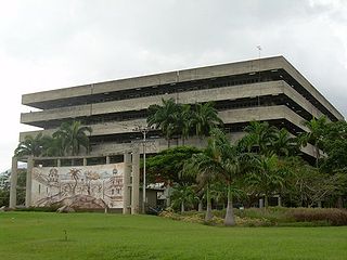
The University of Carabobo is an autonomous, public university of Venezuela located in Valencia, Venezuela. It offers graduate and postgraduate studies in different areas. The university offers a lot of green spaces for student recreation, as well architectural art around the faculties, a theater, and two dining halls. There are around 65,000 students, mostly coming from the central part of the country.

Tucacas is a northern coastal town of Venezuela. It is located in the state of Falcón.

John Carruthers was a British engineer and economic theorist from a Scottish literary family. He was born in Inverness, Inverness-shire, Scotland on 21 June 1836.

<span class="mw-page-title-main">Great Venezuela Railway</span>

The Great Venezuela Railway was a 179-kilometre (111 mi) 3 ft 6 in railway from Caracas to Valencia. The railway was the longest in Venezuela. It proved difficult to recoup the initial investment and the railway became a notable cause of the Venezuelan crisis of 1902–1903. It fell into disrepair through the early 20th century and the last train ran in 1966.

<span class="mw-page-title-main">Plaza Bolívar (Valencia)</span>

The Plaza Bolívar is a square in Valencia, Venezuela. It occupies a central site, and is used for public meetings. Its origin was in the colonial period, when the city was laid out on a grid plan.(see note) Some buildings in the vicinity, such as the Cathedral date from the colonial period.

<span class="mw-page-title-main">Camoruco railway station</span> Railroad station

The Camoruco railway terminus in Valencia, Venezuela, is a rare survival of a 19th century railway station in the South America country. The building is also known as the Rectorado of the University of Carabobo. When the Puerto Cabello and Valencia railway closed in the 1950s, the station was transferred to the University of Carabobo which converted it for administrative use.

<span class="mw-page-title-main">Aguas Calientes River (Carabobo)</span> River in Carabobo, Venezuela

Aguas Calientes is the name of a river in Carabobo state.

<span class="mw-page-title-main">Las Trincheras</span> Place in Carabobo, Venezuela

Las Trincheras, also known as Las Trincheras de Aguas Calientes, is a locality near Valencia, Venezuela. It is noted for its hot springs, which feed into the Aguas Calientes River.

<span class="mw-page-title-main">Bárbula</span> Place in Carabobo, Venezuela

Bárbula is a locality in Naguanagua Municipality, Venezuela. It has the main campus of the University of Carabobo. The facilities include a palmetum, the Parque Universitario Palmetum.

Bárbula Tunnel is a partly-constructed railway tunnel in Venezuela. It is between Las Trincheras and Naguanagua in Carabobo state. The tunnel has a length of 7.8 km (4.8 mi), which makes it the longest in South America.

La Encrucijada, or La Encrucijada de Turmero, is a strategic road junction near Turmero, Venezuela. It is also planned to be a rail junction.

<span class="mw-page-title-main">La Guaira and Caracas Railway</span>

The La Guaira to Caracas Railway was a narrow-gauge railway in Venezuela. From 1883 to 1951 it linked Caracas, the capital of Venezuela, to its port La Guaira. Caracas is only 7 miles (11 km) from the Caribbean. However, the city is at an altitude of 3,000 feet, so the line extended to 23 miles in order to mitigate the gradients. To help with the mountainous terrain, the line used a narrow gauge. At 36-inches the track gauge was narrower than that of the Great Venezuela Railway, for example. There were 8 tunnels.

References

  1. 1 2 Chisholm, Hugh, ed. (1911). "Valencia (Venezuela)"  . Encyclopædia Britannica . Vol. 27 (11th ed.). Cambridge University Press. p. 846.
  2. 1 2 Carruthers, John (1889). "The Trincheras Steep Incline on the Puerto Cabello and Valencia Railway, Venezuela". Minutes of the Proceedings of the Institution of Civil Engineers. ICE Publishing. 96. doi:10.1680/imotp.1889.20790.
  3. Harrison, William Jerome (1889). "Fairlie, Robert Francis"  . In Stephen, Leslie (ed.). Dictionary of National Biography . Vol. 18. London: Smith, Elder & Co. p. 153.
  4. "Obituary: John Carruthers". Minutes of the Proceedings of the Institution of Civil Engineers . 198. 1914. doi:10.1680/imotp.1914.16319.
  5. Morrison, A. "Map of Valencia" . Retrieved 14 April 2019.
  6. Railways of South America: Puerto Cabello and Valencia Railway. 1927.
  7. "Puerto Cabello-La Encrucijada Rail Line in Venezuela is 50% Complete". 2008. Retrieved 2019-04-27.
  8. Guthrie (2016). "Salini Impregilo beats targets - KHL Group". www.khl.com. Retrieved 2019-04-27.