
Saxe-Coburg and Gotha, or Saxe-Coburg-Gotha, was an Ernestine duchy in Thuringia ruled by a branch of the House of Wettin, consisting of territories in the present-day states of Thuringia and Bavaria in Germany. It lasted from 1826 to 1918. In November 1918, Charles Edward, Duke of Saxe-Coburg and Gotha, was forced to abdicate. In 1920, the northern part of the duchy was merged with six other Thuringian free states to form the Free State of Thuringia: Saxe-Weimar-Eisenach, Saxe-Altenburg and Saxe-Meiningen, Schwarzburg-Rudolstadt and Schwarzburg-Sondershausen, as well as the People's State of Reuss. The southern part of the duchy, as southernmost of the Thuringian states, was the only one which, after a referendum, became part of the Free State of Bavaria.
Coburg is a Landkreis (district) in Bavaria, Germany. It is bounded by the districts of Kronach, Lichtenfels, Bamberg and Haßberge, and by the state of Thuringia. The district surrounds, but does not include the city of Coburg.
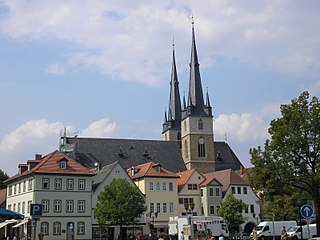
Gotha is a Kreis (district) in western central Thuringia, Germany. Neighboring districts are Unstrut-Hainich-Kreis, Sömmerda, the Kreis-free city Erfurt, Ilm-Kreis, Schmalkalden-Meiningen and the Wartburgkreis.
The House of Wettin was a dynasty of German kings, prince-electors, dukes, and counts that once ruled territories in the present-day German states of Saxony, Saxony-Anhalt and Thuringia. The dynasty is one of the oldest in Europe, and its origins can be traced back to the town of Wettin, Saxony-Anhalt. The Wettins gradually rose to power within the Holy Roman Empire. Members of the family became the rulers of several medieval states, starting with the Saxon Eastern March in 1030. Other states they gained were Meissen in 1089, Thuringia in 1263, and Saxony in 1423. These areas cover large parts of Central Germany as a cultural area of Germany.
Saalfeld is a town in Germany, capital of the Saalfeld-Rudolstadt district of Thuringia. It is best known internationally as the ancestral seat of the Saxe-Coburg and Gotha branch of the Saxon House of Wettin.

Coburg is a town located on the Itz river in the Upper Franconia region of Bavaria, Germany. Long part of one of the Thuringian states of the Wettin line, it joined Bavaria by popular vote only in 1920. Until the revolution of 1918, it was one of the capitals of the Duchy of Saxe-Coburg and Gotha and the Duchy of Saxe-Coburg-Saalfeld.
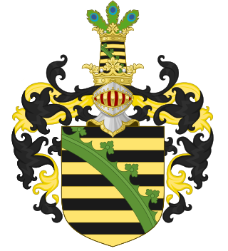
The House of Saxe-Coburg and Gotha is a European royal house. It takes its name from its oldest domain, the Ernestine duchy of Saxe-Coburg and Gotha, and its members later sat on the thrones of Belgium, Bulgaria, Portugal, and the United Kingdom and its dominions.

Neustadt bei Coburg is a town in the district of Coburg in northern Bavaria, Germany. It is situated 15 km northeast of Coburg, as its name indicates.

Bad Rodach is a town in the district of Coburg, in Upper Franconia, a north Bavarian Regierungsbezirk, Germany. It is situated 10 km southeast of Hildburghausen, and 17 km northwest of Coburg. Since 1999 the city has been a spa-resort and is reported to have the warmest thermal spring in the North of Bavaria.

Königsberg in Bayern is a town in the Haßberge district, in Lower Franconia, Bavaria, Germany. It is situated 7 km northeast of Haßfurt, and 31 km northwest of Bamberg.

Sondheim vor der Rhön is a municipality in the district Rhön-Grabfeld, Bavaria, Germany. It is administrated by the Verwaltungsgemeinschaft Ostheim. As of 2002 it had a population of 1123, and covers an area of 18.58 km2.

Sonnefeld is a municipality in the district of Coburg in Bavaria in Germany.

Weidhausen bei Coburg is a municipality in the southeastern portion of the Coburg district of Bavaria in Germany.

Rimpar is a market town in the district of Würzburg in the German state of Bavaria. It is located about 10 km (6 mi) north of the City of Würzburg. The municipality includes the villages of Gramschatz and Maidbronn, incorporated in 1978.

Körner is a municipality in the Unstrut-Hainich-Kreis district of Thuringia, Germany.
Hubertus Prinz von Sachsen-Coburg und Gotha is the eldest son of Ernst-Leopold Prinz von Sachsen-Coburg und Gotha and his first wife, Ingeborg Henig.
The Principality of Lichtenberg on the Nahe River was an exclave of the Duchy of Saxe-Coburg-Saalfeld from 1816 to 1826 and the Duchy of Saxe-Coburg and Gotha from 1826 to 1834, when it was sold to the Kingdom of Prussia. Today its territories lie in two States of Germany: the District of St. Wendel in Saarland and the District of Birkenfeld in Rhineland-Palatinate.

The Veste Coburg is one of the best-preserved medieval fortresses of Germany. It is situated on a hill above the town of Coburg, in the Upper Franconia region of Bavaria.

Buch am Forst is a village of 530 inhabitants in the district town (Kreisstadt) of Lichtenfels in the state of Bavaria in Germany. It is 6 kilometers northwest of Lichtenfels and at the western edge of the Lichtenfels Forest. Bundesautobahn 73 [Federal Highway] runs approximately a half-mile (1 km) to the east, while Kreisstraße [District Road] LIF27 goes through the village itself.
The Free State of Coburg emerged from the Duchy of Saxe-Coburg and Gotha at the end of the First World War. It existed from November 1918 until its union with the Free State of Bavaria on 1 July 1920.


