Lautertal, Bavaria

Last updated
Lautertal
Unterlauter-Kirche.jpg
Protestant church
DEU Lautertal Oberfr. COA.svg
Location of Lautertal within Coburg district
Lautertal in CO.svgCallenberger Forst-WestGellnhausenLautertalAhorn
Germany adm location map.svg
Red pog.svg
Lautertal
Bavaria location map.svg
Red pog.svg
Lautertal
Coordinates: 50°20′N10°58′E / 50.333°N 10.967°E / 50.333; 10.967
Country Germany
State Bavaria
Admin. region Oberfranken
District Coburg
Government
   Mayor (201925) Karl Kolb [1]
Area
  Total30.34 km2 (11.71 sq mi)
Highest elevation
527 m (1,729 ft)
Lowest elevation
300 m (1,000 ft)
Population
 (2022-12-31) [2]
  Total4,520
  Density150/km2 (390/sq mi)
Time zone UTC+01:00 (CET)
  Summer (DST) UTC+02:00 (CEST)
Postal codes
96486
Dialling codes 09561, 09566
Vehicle registration CO, NEC
Website www.gemeindelautertal.de

Lautertal is a municipality in the district of Coburg in Bavaria in Germany. Near Lautertal, there was between 1952 and 1992 a DECCA-transmitter.

Contents

Geography

Lautertal is in the north of the district of Coburg between the state of Thuringia and Coburg. The municipality consists of the six villages Unterlauter, Oberlauter, Tiefenlauter, Neukirchen, Tremersdorf and Rottenbach. The Buchberg (close to Rottenbach) is the highest elevation in the district.

Climate

Climate data for Lautertal (1991–2020 normals)
MonthJanFebMarAprMayJunJulAugSepOctNovDecYear
Average high °C (°F)2.6
(36.7)
4.3
(39.7)
9.0
(48.2)
14.6
(58.3)
18.8
(65.8)
22.2
(72.0)
24.4
(75.9)
24.4
(75.9)
19.1
(66.4)
13.3
(55.9)
6.8
(44.2)
3.4
(38.1)
13.6
(56.5)
Daily mean °C (°F)0.1
(32.2)
0.8
(33.4)
4.4
(39.9)
9.1
(48.4)
13.3
(55.9)
16.5
(61.7)
18.5
(65.3)
18.1
(64.6)
13.7
(56.7)
9.0
(48.2)
4.2
(39.6)
1.0
(33.8)
9.1
(48.4)
Average low °C (°F)−2.5
(27.5)
−2.4
(27.7)
0.3
(32.5)
3.5
(38.3)
7.5
(45.5)
10.6
(51.1)
12.6
(54.7)
12.4
(54.3)
8.8
(47.8)
5.3
(41.5)
1.5
(34.7)
−1.3
(29.7)
4.7
(40.5)
Average precipitation mm (inches)57.0
(2.24)
44.2
(1.74)
45.4
(1.79)
39.4
(1.55)
65.2
(2.57)
66.5
(2.62)
84.9
(3.34)
57.9
(2.28)
57.2
(2.25)
50.4
(1.98)
55.7
(2.19)
65.7
(2.59)
681.0
(26.81)
Average precipitation days (≥ 0.1 mm)17.615.514.913.013.413.815.213.212.314.916.419.0179.6
Average relative humidity (%)85.181.475.668.769.570.470.769.777.183.187.087.277.1
Mean monthly sunshine hours 47.371.1121.5180.4205.7211.4220.8208.9150.5102.444.637.41,594.3
Source: World Meteorological Organization [3]

Infrastructure

Car

Lautertal has two junctions to Bundesautobahn 73 motorway in the north and south. The former route of the Bundesstraße 4 is the longest main road of the village.

Rail Transport

The Eisenach-Lichtenfels railway line, also known as the Werra Valley Railway, ran through Lautertal until the 1970s. There was a train station in Tiefenlauter. Due to the fact that Thuringia belonged to the GDR, the train traffic was separated, later the route had to be abandoned. A reactivation is demanded by many, however the municipality is against it.

Public Transport

Oberlauter and Unterlauter are connected to Coburg by city bus line 2. The additional line 8318 connects all the other villages with Coburg.

Related Research Articles

Coburg is a Landkreis (district) in Bavaria, Germany. It is bounded by the districts of Kronach, Lichtenfels, Bamberg and Haßberge, and by the state of Thuringia. The district surrounds, but does not include the city of Coburg.

Gotha is a Kreis (district) in western central Thuringia, Germany. Neighboring districts are Unstrut-Hainich-Kreis, Sömmerda, the Kreis-free city Erfurt, Ilm-Kreis, Schmalkalden-Meiningen and the Wartburgkreis.

<span class="mw-page-title-main">Saalfeld</span> Town in Thuringia, Germany

Saalfeld is a town in Germany, capital of the Saalfeld-Rudolstadt district of Thuringia. It is best known internationally as the ancestral seat of the Saxe-Coburg and Gotha branch of the Saxon House of Wettin.

<span class="mw-page-title-main">Leinefelde-Worbis</span> Town in Thuringia, Germany

Leinefelde-Worbis is a town in the district of Eichsfeld, in northwestern Thuringia, Germany. The town was formed on March 16, 2004, from the former independent towns Leinefelde and Worbis along with the municipalities of Breitenbach and Wintzingerode. In July 2018 the former municipality of Hundeshagen, and in January 2019 Kallmerode was merged into Leinefelde-Worbis. The population before the amalgamation was 14,387 for Leinefelde, 5,541 for Worbis, 1,021 for Breitenbach and 614 for Wintzingerode. The 10 parts of Leinefelde-Worbis are Leinefelde, Worbis, Breitenbach, Kirchohmfeld, Birkungen, Beuren, Hundeshagen, Kaltohmfeld, Wintzingrode, Kallmerode and Breitenholz.

<span class="mw-page-title-main">Mühldorf</span> Town in Bavaria, Germany

Mühldorf am Inn is a town in Bavaria, Germany, and the capital of the district Mühldorf on the river Inn. It is located at 48°14′30″N12°31′30″E, and had a population of about 17,808 in 2005.

<span class="mw-page-title-main">Sonneberg</span> Town in Thuringia, Germany

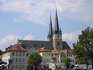
Sonneberg in Thuringia, Germany, is the seat of the Sonneberg district. It is in the Franconian south of Thuringia, neighboring its Upper Franconian twin town Neustadt bei Coburg.

<span class="mw-page-title-main">Artern</span> Town in Thuringia, Germany

Artern is a town in the Kyffhäuserkreis district, Thuringia, Germany. The former municipalities Heygendorf and Voigtstedt were merged into Artern in January 2019.

<span class="mw-page-title-main">Neustadt bei Coburg</span> Town in Bavaria, Germany

Neustadt bei Coburg is a town in the district of Coburg in northern Bavaria, Germany. It is situated 15 km northeast of Coburg, as its name indicates.

<span class="mw-page-title-main">Königsee</span> Town in Thuringia, Germany

Königsee is a town and a municipality in the district of Saalfeld-Rudolstadt, in Thuringia, Germany. It is situated 12 kilometres (7.5 mi) east of Ilmenau, and 35 kilometres (22 mi) south of Erfurt. The present municipality was formed on 31 December 2012 by the merger of the former municipalities Königsee and Rottenbach, under the name Königsee-Rottenbach. On 1 January 2019 the former municipalities Dröbischau and Oberhain were absorbed, and the name was changed to Königsee.

<span class="mw-page-title-main">Ludwigsstadt</span> Town in Bavaria, Germany

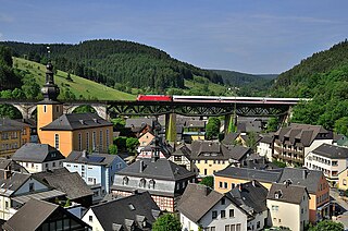
Ludwigsstadt is a town in the district of Kronach, in the Upper Franconian region of Bavaria, Germany.

<span class="mw-page-title-main">Schalkau</span> Town in Thuringia, Germany

Schalkau is a town in the district of Sonneberg, in Thuringia, Germany. It is situated 13 km west of Sonneberg, and 15 km north of Coburg. The former municipality Bachfeld was merged into Schalkau in December 2019.

<span class="mw-page-title-main">Sonnefeld</span> Municipality in Bavaria, Germany

Sonnefeld is a municipality in the district of Coburg in Bavaria in Germany.

<span class="mw-page-title-main">Röttenbach</span> Town in Erlangen-Höchstadt district, Bavaria, Germany

Röttenbach is a town in the district of Erlangen-Höchstadt, in Bavaria, Germany.

<span class="mw-page-title-main">Bad Grönenbach</span> Municipality in Bavaria, Germany

Bad Grönenbach is a market town in the district of Unterallgäu in Bavaria, Germany. It belongs to the region of Upper Swabia and the headquarters of the Gemeindeverband of the same name.

<span class="mw-page-title-main">Pleinfeld</span> Municipality in Bavaria, Germany

Pleinfeld is a Franconian municipality and market town in the Weißenburg-Gunzenhausen district, in the German state of Bavaria. It is situated in the Metropolitan Area of Nuremberg and in the Franconian Lake District. Pleinfeld is a nationally recognized recreation area.

<span class="mw-page-title-main">Hohenpeißenberg</span> Municipality in Bavaria, Germany

Hohenpeißenberg is a municipality in the Weilheim-Schongau district, in Bavaria, Germany. Hohenpeißenberg is situated in the Bavarian Oberland, in the Alpine Foreland.

<span class="mw-page-title-main">Fürstenzell</span> Municipality in Bavaria, Germany

Fürstenzell is a municipality in the district of Passau in Bavaria in Germany.

<span class="mw-page-title-main">Eisenach–Lichtenfels railway</span>

The Eisenach–Lichtenfels railway is a single-tracked main line with a standard gauge of 1,435 mm in Thuringia and Bavaria in southern and central Germany, that runs mostly along the river Werra. It runs from Eisenach via Meiningen to Eisfeld and, formerly, continued to Coburg and Lichtenfels. It was opened in 1858 and is one of the oldest railways in Germany. The railway company that built it, the Werra Eisenbahngesellschaft with its headquarters in Meiningen was also often called the Werrabahn. The company also ran various lines branching off the Werra Railway.

<span class="mw-page-title-main">Lauter (Itz)</span> River of Bavaria, Germany

Lauter is a river of Bavaria, Germany. It is a right tributary of the Itz in Coburg.

Rottenbach or Röttenbach may refer to:

References

  1. Liste der ersten Bürgermeister/Oberbürgermeister in kreisangehörigen Gemeinden, Bayerisches Landesamt für Statistik, accessed 19 July 2021.
  2. Genesis Online-Datenbank des Bayerischen Landesamtes für Statistik Tabelle 12411-003r Fortschreibung des Bevölkerungsstandes: Gemeinden, Stichtag (Einwohnerzahlen auf Grundlage des Zensus 2011)
  3. "World Meteorological Organization Climate Normals for 1991–2020". World Meteorological Organization Climatological Standard Normals (1991–2020). National Oceanic and Atmospheric Administration. Retrieved 12 October 2023.