Sonnefeld

Last updated
Sonnefeld
Municipality
Sonnefeld-Rathaus.jpg
Town hall
DEU Sonnefeld COA.svg
Location of Sonnefeld within Coburg district
Sonnefeld in CO.svg
Germany adm location map.svg
Red pog.svg
Sonnefeld
Bavaria location map.svg
Red pog.svg
Sonnefeld
Coordinates: 50°13′N11°7′E / 50.217°N 11.117°E / 50.217; 11.117 Coordinates: 50°13′N11°7′E / 50.217°N 11.117°E / 50.217; 11.117
Country Germany
State Bavaria
Admin. region Oberfranken
District Coburg
Government
   Mayor (202026) Michael Keilich [1] (CSU)
Area
  Total34.69 km2 (13.39 sq mi)
Elevation
318 m (1,043 ft)
Population
 (2020-12-31) [2]
  Total4,608
  Density130/km2 (340/sq mi)
Time zone UTC+01:00 (CET)
  Summer (DST) UTC+02:00 (CEST)
Postal codes
96242
Dialling codes 09562
Vehicle registration CO
Website sonnefeld.de

Sonnefeld is a municipality in the district of Coburg in Bavaria in Germany.

Contents

Geographical Location

Sonnefeld lies on Bundesstraße 303 between Coburg and Kronach and also between the Thuringian Forest and the Lichtenfels Forest.

Municipal Division

The municipality of Sonnefeld is divided in eleven districts:

History

The first documented mention of Sonnefeld was in the year 1252. In 1260, a Cistercian nunnery was founded in Ebersdorf bei Coburg by Henry II von Sonneberg with the help from the nuns from Maidbronn. Three years later, in 1263, the nearby hamlet of Hofstädten became the property of the nunnery. When it burned to the ground in 1287, a new abbey was built and consecrated in Hofstädten for the nuns. In 1299, the villages of Weidhausen and Trübenbach were given to Sonnefeld Abbey in an exchange of properties with Bamberg. A church was added between 1330 and 1349 in the High Gothic style and became the Klosterkirche (monastery church).

In 1526, the abbey was dissolved as a result of the Reformation. Since then, Sonnefeld has been an Evangelical Lutheran parish. The Thirty Years' War destroyed most of the houses and buildings in Sonnefeld and Hofstädten so the reconstruction was slow but steady. It got a big boost from the grant of market privileges by Duke Albert V, Duke of Saxe-Coburg. In 1705, the district of Sonnefeld came to the Duchy of Saxe-Hildburghausen. In 1769, the parish church was rebuilt. In 1826, the district of Sonnefeld was given to the Duchy of Saxe Coburg and Gotha in the redistribution of lands between the surviving Saxon duchies.

On 1 May 1851 the cantor Karl Herold founded a children's festival. On 23 June 1889 Sonnefeld and Hofstädten were merged as a single town under the name of Sonnefeld. In the same year, a war memorial was unveiled in the town square (Marktplatz), and the first railway line opened at Sonnefeld in 1901. During World War I, Sonnefeld had to surrender three church bells and the pipes of the church's organ to the war effort but they were replaced and dedicated in 1919 and 1924 respectively. On 1 June 1920, the dissolution of Saxe-Coburg and Gotha sent the district of Coburg, including Sonnefeld, to Bavaria. Before World War II, 1400 people were counted in Sonnefeld but in 1966 the population was down to 980 residents in 556 households. However, the subsequent additions, a total of 10 villages, to the municipality increased the population to 5,300.

Coat of arms

Blazon: Per fess azure and argent (divided horizontally in blue and white, with the top in blue), in chief a church argent roofed gules (with a profile of a white church with red roofs) and in base an oak tree erased proper. (The church is the former abbey church of Sonnefeld and the oak is the traditional symbol of Hofstädten).

Politics

The Town Council has 20 members. The municipal elections of 2008 led to the following distribution of the seats in the council: 8 seats for CSU, 7 seats for SPD, and 5 seats for Independents.

Economy

Until the 19th Century, Sonnefeld was primarily an agricultural village. Then basketmaking became the main business of the village, with products exported all over the world. After the end of World War I, workshops were created to make willow chairs, wicker furniture, baby carriages, and upholstered furniture. They were the ones that eventually replaced basketmaking. They were joined by industrial jobs in nearby towns and villages in the post-World War II boom. The prosperity made it possible for Sonnefeld to add a water supply system, a fully biological sewage treatment plant, an elementary school with a gym, and a heated swimming pool.

Other Facts

In Sonnefeld, Itzgründisch, an East Franconian German dialect of High German, is spoken.

Notable residents

Related Research Articles

Birkenfeld is a district (Landkreis) in Rhineland-Palatinate, Germany. Its seat is the town of Birkenfeld. It is bounded by the districts of Sankt Wendel (Saarland), Trier-Saarburg, Bernkastel-Wittlich, Rhein-Hunsrück, Bad Kreuznach and Kusel.

Coburg is a Landkreis (district) in Bavaria, Germany. It is bounded by the districts of Kronach, Lichtenfels, Bamberg and Haßberge, and by the state of Thuringia. The district surrounds, but does not include the city of Coburg.

Gotha (district) District in Thuringia, Germany

Gotha is a Kreis (district) in western central Thuringia, Germany. Neighboring districts are Unstrut-Hainich-Kreis, Sömmerda, the Kreis-free city Erfurt, Ilm-Kreis, Schmalkalden-Meiningen and the Wartburgkreis.

Saalfeld Town in Thuringia, Germany

Saalfeld is a town in Germany, capital of the Saalfeld-Rudolstadt district of Thuringia. It is best known internationally as the ancestral seat of the Saxe-Coburg and Gotha branch of the Saxon House of Wettin, which was renamed the House of Windsor during their British reign in 1917.

Oberhof, Germany Stadt in Thuringia, Germany

Oberhof is a town in the Schmalkalden-Meiningen district of Thuringia, Germany. Located in the Thuringian Forest mountain range, it is a winter sports center and health resort. With 1,625 inhabitants, it is visited by 144,000 tourists every year (2016). The town obtained its official city status in 1985.

Geroldsgrün Municipality in Hof, Bavaria, Germany

Geroldsgrün is a municipality in the Hof district of Bavaria, Germany.

Neustadt bei Coburg Stadt in Bavaria, Germany

Neustadt bei Coburg is a town in the district of Coburg in northern Bavaria, Germany. It is situated 15 km northeast of Coburg, as its name indicates.

Bad Rodach Stadt in Bavaria, Germany

Bad Rodach is a town in the district of Coburg, in Upper Franconia, a north Bavarian Regierungsbezirk, Germany. It is situated 10 km southeast of Hildburghausen, and 17 km northwest of Coburg. Since 1999 the city has been a spa-resort and is reported to have the warmest thermal spring in the North of Bavaria.

Ichenhausen Stadt in Bavaria, Germany

Ichenhausen is a town in the district of Günzburg, in Bavaria, Germany. It is situated on the river Günz, 9 km south of Günzburg.

Seßlach Stadt in Bavaria, Germany

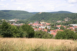
Seßlach is a town in the district of Coburg, in northern Bavaria, Germany. It is situated 12 km southwest of Coburg and has a population close to 4,000.

Gebsattel Municipality in Bavaria, Germany

Gebsattel is a municipality in the district of Ansbach in Bavaria in Germany. It lies on the Tauber River.

Biberbach, Bavaria Municipality in Bavaria, Germany

Biberbach is a municipality in the northern part of the district of Augsburg in Bavaria in Germany. A famous baroque pilgrimage church is located on the hill above the village.

Ebrach Markt in Bavaria, Germany

Ebrach is a community with market rights in the Upper Franconian district of Bamberg and the seat of the Verwaltungsgemeinschaft of Ebrach.

Wald (Allgäu) Municipality in Bavaria, Germany

Wald is a municipality in the district of Ostallgäu in Bavaria in Germany.

Westendorf (Allgäu) Municipality in Bavaria, Germany

Westendorf is a municipality in the district of Ostallgäu in Bavaria in Germany.

Rimpar Municipality in Bavaria, Germany

Rimpar is a market town in the district of Würzburg in the German state of Bavaria. It is located about 10 km (6 mi) north of the City of Würzburg. The municipality includes the villages of Gramschatz and Maidbronn, incorporated in 1978.

Ahorn, Bavaria Municipality in Bavaria, Germany

Ahorn is a municipality in the district of Coburg in Bavaria in Germany.

Heimbach (Nahe) Municipality in Rhineland-Palatinate, Germany

Heimbach is an Ortsgemeinde – a municipality belonging to a Verbandsgemeinde, a kind of collective municipality – in the Birkenfeld district in Rhineland-Palatinate, Germany. It belongs to the Verbandsgemeinde of Baumholder, whose seat is in the like-named town.

Menteroda Municipality in Thuringia, Germany

Menteroda is a municipality in the Unstrut-Hainich-Kreis district of Thuringia, Germany.

Frohnlach Ortsteil of Ebersdorf bei Coburg in Bavaria, Germany

Frohnlach is located in Upper Franconia (Oberfranken) in the district of (Landkreis) Coburg. It is the easternmost part of the municipality (Gemeinde) of Ebersdorf bei Coburg and, with around 2,000 inhabitants, the largest district after Ebersdorf.
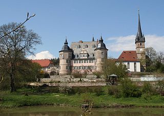
References

  1. Liste der ersten Bürgermeister/Oberbürgermeister in kreisangehörigen Gemeinden, Bayerisches Landesamt für Statistik, 15 July 2021.
  2. "Tabellenblatt "Daten 2", Statistischer Bericht A1200C 202041 Einwohnerzahlen der Gemeinden, Kreise und Regierungsbezirke". Bayerisches Landesamt für Statistik (in German). June 2021.

Literature