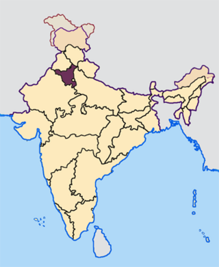
Nalwa is a village, as well as an Assembly Constituency in Haryana Legislative Assembly, located in Hisar district in the state of Haryana in India.
Nasirabad is a cantonment town in Ajmer district in the Indian state of Rajasthan.
Bagoran also spelled as Baghoran is a village in Shaheed Bhagat Singh Nagar district of Punjab State, India. It is located 2.7 kilometres (1.7 mi) away from postal head office Mukandpur, 11.2 kilometres (7.0 mi) from Banga, 16.8 kilometres (10.4 mi) from district headquarter Shaheed Bhagat Singh Nagar and 92.5 kilometres (57.5 mi) from state capital Chandigarh. The village is administrated by Sarpanch an elected representative of the village.
Langeri is a village in Shaheed Bhagat Singh Nagar district of Punjab State, India. It is located 6.4 kilometres (4.0 mi) away from postal head office Behram, 8 kilometres (5.0 mi) from Banga, 19 kilometres (12 mi) from district headquarter Shaheed Bhagat Singh Nagar and 112 kilometres (70 mi) from state capital Chandigarh. The village is administrated by Sarpanch an elected representative of the village.
Barnala Khurd is a village in Shaheed Bhagat Singh Nagar district of Punjab State, India. Kalan is Persian language word which means Big and Khurd is Persian word which means small when two villages have same name then it is distinguished as Kalan means Big and Khurd means Small with Village Name. It is situated on Ludhiana-Rahon road and located 4.1 kilometres (2.5 mi) away from Rahon, 20 kilometres (12 mi) from Banga, 12 kilometres (7.5 mi) from district headquarter Shaheed Bhagat Singh Nagar and 93 kilometres (58 mi) from state capital Chandigarh. The village is administrated by Sarpanch an elected representative of the village.
Jadla is a village in Shaheed Bhagat Singh Nagar district of Punjab State, India. It is located 30 kilometres (19 mi) away from postal head office Lassara, 12 kilometres (7.5 mi) from Nawanshahr, 20 kilometres (12 mi) from district headquarter Shaheed Bhagat Singh Nagar and 80 kilometres (50 mi) from state capital Chandigarh. The village is administrated by Sarpanch an elected representative of the village.
Jhander Kalan is a village in Shaheed Bhagat Singh Nagar district of Punjab State, India. Kalan is a Persian word for big and Khurd is a Persian word for small, when two villages have the same name they are distinguished by using Kalan or Khurd with the village name. It is located 9.2 kilometres (5.7 mi) away from postal head office Banga, 23 kilometres (14 mi) from Phagwara, 20 kilometres (12 mi) from district headquarter Shaheed Bhagat Singh Nagar and 113 kilometres (70 mi) from state capital Chandigarh. The village is administrated by Sarpanch an elected representative of the village.
Kahlon is a village in Shaheed Bhagat Singh Nagar district of Punjab State, India. It is located 3.8 kilometres (2.4 mi) away from postal head office Rahon, 11 kilometres (6.8 mi) from Nawanshahr, 12.7 kilometres (7.9 mi) from district headquarter Shaheed Bhagat Singh Nagar and 92.7 kilometres (57.6 mi) from state capital Chandigarh. The village is administrated by Sarpanch an elected representative of the village.
Kahma is a village in Shaheed Bhagat Singh Nagar district of Punjab State, India. It is situated on Phagwara-Mohali expressway located 5.4 kilometres (3.4 mi) away from Banga, 9 kilometres (5.6 mi) from Nawanshahr, 10.4 kilometres (6.5 mi) from district headquarter Shaheed Bhagat Singh Nagar and 96 kilometres (60 mi) from state capital Chandigarh. The village is administrated by Sarpanch an elected representative of the village, Husnlal Bhagatram born in the village they're the first legendary music directors duo in Bollywood. They are two brothers, Husn Lal and Bhagat Ram. Husn Lal was also a renowned violinist, vocalist and music composer, but his prowess as singer is not commonly known. Bhagat Ram was considered an expert harmonium player.
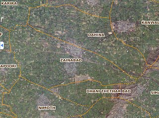
Zainabad is a village located in DAHINA Block of Rewari district in Haryana. Positioned in rural area of Rewari district of Haryana, it is one of the 39 villages of Dahina Block of Rewari district. As per the government records, the village code of Zainabad is 62460. The village has 1072 families.
Ajmer is a tehsil in Ajmer district of Rajasthan state in India. It consists of 4 census towns and 85 villages. The capital of the tehsil is the eponymous Ajmer.
Badlya is a census town in Ajmer tehsil of Ajmer district of Rajasthan state in India. The census town and village falls under Badlya gram panchayat.
Boraj-Kazipura is a census town in Ajmer tehsil of Ajmer district of Rajasthan state in India. The census town and village falls under Hathi khera gram panchayat.
Amba Maseena is a village in Ajmer tehsil of Ajmer district of Rajasthan state in India. The village falls under Doomara gram panchayat.
Baghpura is a village in Ajmer tehsil of Ajmer district of Rajasthan state in India. The village falls under Aradka gram panchayat.
Banseli is a village in Ajmer tehsil of Ajmer district of Rajasthan state in India.The village falls under Deo nagar gram panchayat.
Bargaon is a village in Ajmer tehsil of Ajmer district of Rajasthan state in India. The village falls under Sedariya gram panchayat.
Bhawani Khera is a village in Ajmer tehsil of Ajmer district of Rajasthan state in India. The village falls under Narwar gram panchayat.
Bhoodol also spelled as Bhudol is a village in Ajmer tehsil of Ajmer district of Rajasthan state in India. The village falls under Bhoodol gram panchayat.
Chawandiya is a village in Ajmer tehsil of Ajmer district of Rajasthan state in India. The village falls under Ganahera gram panchayat.

