
Aketi is a town in the Bas-Uele Province of the Democratic Republic of the Congo. It is the seat of Aketi Territory. As of 2009 it had an estimated population of 38,588.
Bondo Territory is a territory in the Bas-Uele Province of the Democratic Republic of the Congo. The administrative capital is the town of Bondo.
Ango Territory is a territory in the Bas-Uele Province of the Democratic Republic of the Congo. The administrative capital is located at Ango. The territory borders Bondo Territory to the west, Central African Republic to the north, Bambesa Territory to the southwest, Poko Territory to the southeast and Dungu Territory in Haut-Uele Province to the east.
Likati River is a river of northern Democratic Republic of the Congo, a tributary of the Itimbiri River. It flows through Aketi Territory in Bas-Uele District.
Tinda River is a river of northern Democratic Republic of the Congo. It flows through Aketi Territory in Bas-Uele District.
Aketi River is a river of the northern Democratic Republic of the Congo. It flows through Aketi Territory in Bas-Uele District.
Yoko River is a river of northern Democratic Republic of the Congo. It flows through Aketi Territory in Bas-Uele District.
Lese River is a river of northern Democratic Republic of the Congo. It flows through Aketi Territory in Bas-Uele District.
Buta Territory is a territory in Bas-Uele District, Orientale Province, Democratic Republic of the Congo. The administrative capital is located at Buta.

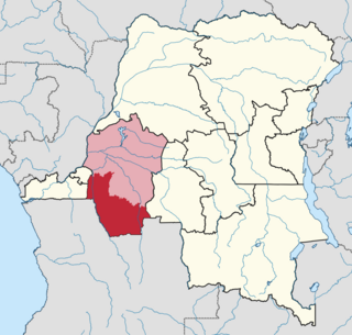
Bas-Uélé is one of the 21 new provinces of the Democratic Republic of the Congo created in the 2015 repartitioning. Bas-Uélé, Haut-Uélé, Ituri, and Tshopo provinces are the result of the dismemberment of the former Orientale Province. Bas-Uélé was formed from the Bas-Uele District whose town of Buta was elevated to capital city of the new province.

Équateur District was a former district of the Congo Free State, Belgian Congo and Democratic Republic of the Congo. In 1914 it became part of former Équateur Province. The district went through various changes of extent and name over the years. The original district roughly corresponds to the current provinces of Équateur and Tshuapa.
Kwango District was a district of the Congo Free State, Belgian Congo and the Democratic Republic of the Congo. It went through various changes in extent. It roughly corresponded to the present provinces of Kwilu and Kwango.
Likati is a town in the Aketi Territory of Bas-Uélé Province in the north of the Democratic Republic of the Congo (DRC).
Uele District was a district of the Congo Free State and the Belgian Congo. It roughly corresponded to the current provinces of Bas-Uélé and Haut-Uélé.
The Itimbiri River is a right tributary of the Congo River, which it joins above Bumba. At one time it was important as a navigable waterway for transporting good from the northeast of the country down to the Congo.
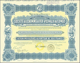
The Société des Chemins de Fer Vicinaux du Congo, known as CVC or Vicicongo, was a railway company that operated the narrow gauge Vicicongo line and provided trucking services in the northeast Belgian Congo, and then in the Democratic Republic of the Congo between 1924 and 1974. It provided transport for agricultural goods produced in the northeast that were shipped on the Congo River to Léopoldville (Kinshasa). After independence in 1960 there were civil disturbances and the railway was poorly maintained. The company was taken over by the state in 1974. Later there were further disturbances in which the stations were destroyed and the rolling stock used as a source of metal. The track is decrepit and no longer usable.
Komba is a village in the Bas-Uélé province of the Democratic Republic of the Congo. It was a junction on the defunct Vicicongo line, a railway.
Libongo or Libogo is a village in the Bas-Uélé province of the Democratic Republic of the Congo. It was a stop on the defunct Vicicongo line, a railway.
Dulia is a village in the Bas-Uélé province of the Democratic Republic of the Congo. It was a station on the defunct Vicicongo line, a railway.
Kotili is a village in the Bas-Uélé province of the Democratic Republic of the Congo. It was a station on the defunct Vicicongo line, a railway.


