
Dhule is a city located in the Dhule District in the northwestern part of Maharashtra state, India known as West Khandesh. Situated on the banks of Panzara River, Dhule is the regional headquarters of MIDC, RTO, and MTDC.
Yavatmal district, [jəʋət̪maːɭ] formerly known as Yeotmal, is a district of the Indian state of Maharashtra. It is located in the region of Vidarbha, in the east-central part of the state. It is Vidarbha's third-largest district by population, after Nagpur and Amravati. Yavatmal city is the administrative headquarters of the district.

Faridkot is a city in the South-western part of state of Punjab, India. It serves as the headquarters for both, the Faridkot district. as well as the Faridkot Division. The division was established in 1995 at Faridkot which includes Faridkot, Bathinda, and Mansa districts.

Amravati district is a district of Maharashtra state in central India. It is the administrative headquarter of Amravati division, which is one of the two divisions in Vidarbha, out of total 6 regions in state of Maharashtra.

Washim district is a district in Maharashtra, India. The headquarters is at Washim. The area of the district is 5,150 km2 (1,990 sq mi).

Khalilabad is a city and a municipal board in Sant Kabir Nagar district in the Indian state of Uttar Pradesh. It is the district headquarters of Sant Kabir Nagar district.

Akola district is a district in the Indian state of Maharashtra. The city of Akola is the district headquarters. Akola district forms the central part of Amravati Division, which was the former British Raj Berar Province.
Dhule district is a district of Maharashtra, India. The city of Dhule is the administrative headquarters of the district. It is part of North Maharashtra.
Pusad is a city in the Yavatmal district located in Vidarbha region of Maharashtra state of India. It is named after the Pus river. Its ancient name was 'Pushpawanti'. Pusad is second largest city of yavatmal district. For last 20 years Pusad is being tried to be promoted to the stature of district but due to lack of administration of governing bodies it is only a dream of the people.
Chikhaldara is a hill station and a municipal council in Amravati district in the Indian state of Maharashtra.
Jaitu is a historical city. Jaitu is a municipal council in Faridkot district in the Indian state of Punjab. It is subdivision in Ferozepur Division. It is 30 km (19 mi) from Bathinda, 130 km (81 mi) from Ludhiana, 150 km (93 mi)from Amritsar, 180 km (110 mi) from Patiala and 234 km (145 mi) from Chandigarh.
Melvisharam is a town and suburb of Vellore city in the Indian state of Tamil Nadu. It is 7 kilometres from Ranipet, 5 km from historic town of Arcot and 17 km from Vellore city.
Morshi is the second largest town in the Amravati district of Maharashtra, India. It is located 55 km north-east of Amravati, situated very close to the border with Madhya Pradesh, in the scenic southern foothills of the Satpura ranges. Morshi and the surrounding region is also known for the cultivation of Nagpur oranges and the prominent Nal Damayanti Dam. Salbardi is very near from morshi.
Pandharkawda is a City and a Municipal council in Yavatmal district in the Indian state of Maharashtra. The Pandharkawada municipality won "Best Municipality at Amravati Division" in 2006 and a quality of education award in 2011. It is near the Saikheda Dam, an earthfill dam on the Khuni River..
Pawai is a town and a nagar panchayat in the Panna district of Madhya Pradesh state in central India. It is mostly surrounded by rocky area.
Umarkhed is a Municipal council in Yavatmal district of Indian State of Maharashtra.
Vaijapur is a city and a municipal council in Aurangabad district in the Indian state of Maharashtra. It is bordered by the Nashik districts to the west, Kannad tehsil to the north, Gangapur tehsil to the east, and Ahmednagar districts to the south. Vaijapur is the headquarters of Vaijapur tehsil and also known as the Gateway of Marathwada.
Warud is also known as Orange City and a municipal council in Amravati district in the Indian state of Maharashtra.

Wani is a 3rd largest city in Yavatmal district in the Indian state of Maharashtra.
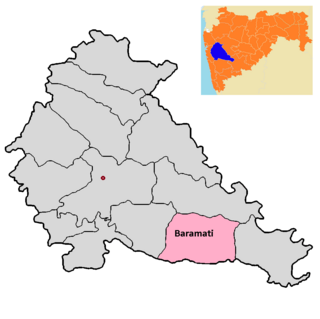
Baramati taluka is a taluka in Baramati subdivision of Pune district of state of Maharashtra in India.


