
Albany is a port city in the Great Southern region in the Australian state of Western Australia, 418 kilometres (260 mi) southeast of Perth, the state capital. The city centre is at the northern edge of Princess Royal Harbour, which is a part of King George Sound. The central business district is bounded by Mount Clarence to the east and Mount Melville to the west. The city is in the local government area of the City of Albany. While it is the oldest colonial, although not European, settlement in Western Australia - predating Perth and Fremantle by over two years - it was a semi-exclave of New South Wales for over four years until it was made part of the Swan River Colony.

The City of Bayswater is a local government area in the Western Australian capital city of Perth, about 7 kilometres (4 mi) northeast of Perth's central business district. The city covers an area of 34.6 square kilometres (13.4 sq mi) and had a population of 69,283 as at the 2021 Census. The City of Bayswater is a member of the Eastern Metropolitan Regional Council.

The Town of Cottesloe is a local government area in the western suburbs of Perth, the capital of Western Australia. It covers the suburb of the same name as well as a tiny portion of the suburb of Claremont. Cottesloe is located 11 kilometres (7 mi) west of Perth's central business district, covers an area of 3.9 square kilometres (1.5 sq mi), maintains 45.7 km of roads and had a population of approximately 7,500 as at the 2016 Census. Cottesloe is served by Swanbourne, Victoria Street, Grant Street and Cottesloe train stations, all operated through the Fremantle Railway Line. Various bus routes operate along Stirling Highway, enabling transport through the suburb's western and eastern precincts with Perth and Fremantle. All services are operated by the Public Transport Authority. The Town of Cottesloe's inclusion of walk and cycle paths enable it to be a walkable precinct.

The Town of Albany was a local government area in the Great Southern region of Western Australia representing the town of Albany, 410 kilometres (255 mi) south-southeast of the capital, Perth.

The Shire of Kojonup is a local government area in the Great Southern region of Western Australia, about 250 kilometres (155 mi) southeast of the state capital, Perth, along Albany Highway. The Shire covers an area of 2,932 square kilometres (1,132 sq mi) and its seat of government is the town of Kojonup.

The Shire of Cranbrook is a local government area in the Great Southern region of Western Australia, about 92 kilometres (57 mi) north of Albany and about 320 kilometres (200 mi) south-southeast of the state capital, Perth. The Shire covers an area of 3,277 square kilometres (1,265 sq mi), and its seat of government is the town of Cranbrook.

The Shire of Katanning is a local government area in the Great Southern region of Western Australia, about 170 kilometres (106 mi) north of Albany and about 290 kilometres (180 mi) southeast of the state capital, Perth. The Shire covers an area of 1,518 square kilometres (586 sq mi), and its seat of government is the town of Katanning.
Mira Mar is a northeastern suburb of Albany, Western Australia, between the Albany city centre and Spencer Park in the local government area of the City of Albany.

Yakkan Toort / Dog Rock is a large, natural granite outcrop that is located along Middleton Road between Middleton Beach and the centre of Albany in the Great Southern region of Western Australia.

The Rocks, also referred to as Government House or Government Cottage, is a residence in Albany in the Great Southern region of Western Australia.

Pyrmont, also referred to as Pyrmont House, is a residence located on Serpentine Road in Albany in the Great Southern region of Western Australia. It is one of the oldest buildings in Albany.

John Moir was prominent businessman and politician who served as the Mayor of Albany in the Great Southern region of Western Australia.

McKenzie House, also referred to as the White House, is a residence in Albany in the Great Southern region of Western Australia.

Patrick Taylor Cottage, also referred to as Patrick Taylor Cottage Museum, is a museum in Albany in the Great Southern region of Western Australia. It the oldest surviving dwelling in Western Australia.

Stirling Terrace, Albany is a street in the centre of Albany, Western Australia adjoining York Street.

The Royal George Hotel is a heritage listed building that operates as a hotel in Albany in the Great Southern region of Western Australia.

Albany House is a heritage listed building located on the corner of Stirling Terrace and York Street overlooking Princess Royal Harbour in Albany in the Great Southern region of Western Australia.
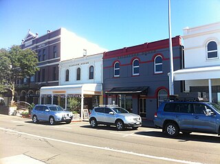
Glasgow House is a heritage listed building located on Stirling Terrace overlooking Princess Royal Harbour in Albany in the Great Southern region of Western Australia.
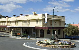
The Premier Hotel is a hotel and a heritage listed building located on the corner of York Street and Grey Street, opposite the Albany Town Hall, in Albany in the Great Southern region of Western Australia.
The State Register of Heritage Places is the heritage register of historic sites in Western Australia deemed significant at the state level by the Heritage Council of Western Australia.

