
Capitol Peak is a high and prominent mountain summit in the Elk Mountains range of the Rocky Mountains of North America. It is the 52nd highest mountain in North America. The 14,137-foot (4,309 m) fourteener is located in the Maroon Bells-Snowmass Wilderness of White River National Forest, 8.7 miles (14.0 km) east by south of the community of Redstone in Pitkin County, Colorado, United States.

Monte Civetta is a prominent and major mountain of the Dolomites, in the Province of Belluno in northern Italy. Its north-west face can be viewed from the Taibon Agordino valley, and is classed as one of the symbols of the Dolomites.

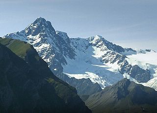
The Grande Casse is the highest mountain of the Vanoise Massif in the Graian Alps in the Savoie department, France. It is located in the heart of Vanoise National Park, near the village of Pralognan-la-Vanoise, which is about 25 km south-east of the nearest town, Moûtiers. It has a steep 600 m high north face. The other sides of the mountain are more gentle, mostly consisting of broken rocks. A high ridge connects it to the nearby peak of Grande Motte. The ridge connecting the Grande Casse and the Grande Motte is the watershed between the Tarentaise Valley in the north and Maurienne Valley to the south.

Aiguille Rouge is a mountain of Savoie, France. It lies in the Vanoise Massif and has an elevation of 3,227 metres above sea level. It is the highest point within the ski area of Les Arcs and is a fairly easy hike from the village below. It can also be accessed by a cable-car which almost reaches the summit area. In 2019 was installed a footbridge at the summit of the mountain that offers a panoramic view of the valley.
The Aiguille des Glaciers is a mountain in the Mont Blanc massif of the Graian Alps. It lies on the borders of Savoie and Haute-Savoie in France and Aosta Valley in Italy.

Aiguille du Belvédère is a mountain of Haute-Savoie, France. It is the highest peak in the Aiguilles Rouges range of the French Prealps and has an altitude of 2,965 metres (9,728 ft) above sea level.

The Aiguille du Chardonnet is a mountain in the Mont Blanc massif in Haute-Savoie, France. It lies between the Glacier du Tour and the Argentière Glacier. The border with Switzerland runs just east of the summit. The East or Forbes Arete provides a popular and classic mountaineering route to the summit.

The Aiguille des Grands Charmoz is a mountain in the Mont Blanc Massif in Haute-Savoie, France.

The Aiguille de Triolet is a mountain on the eastern part the Mont Blanc massif, on the border between France and Italy.

Aiguille de Leschaux is a mountain in the Mont Blanc massif on the border of Haute-Savoie, France and Aosta Valley, Italy.
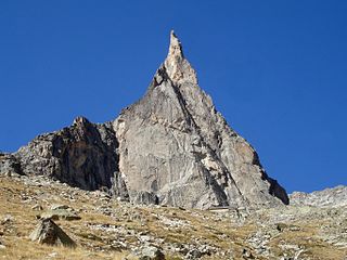
The Aiguille Dibona, formerly called (Aiguille du) Pain de Sucre du Soreiller, is a mountain in the Massif des Écrins in the French Alps notable for its "astonishing triangular granite spear."

The Croce Rossa or Croix Rousse is a mountain of the Graian Alps, on the border between Piedmont, Italy and Savoie, France.

Tofana di Rozes is a mountain of the Dolomites in the Province of Belluno, Veneto, Italy. Located west of the resort of Cortina d'Ampezzo, the mountain's giant three-edged pyramid shape and its vertical south face, above the Falzarego Pass, makes it the most popular peak in the Tofane group, and one of the most popular in the Dolomites.
Tsanteleina (3,601m) is a mountain of the Graian Alps located on the border between Savoie, France and Aosta Valley, Italy. It lies at the head of the Val di Rhèmes, although the summit itself is hidden from view in the valley. The eastern side of the mountain lies within the Gran Paradiso National Park.

Becco di Mezzodì (2,603m) is a mountain of the Croda da Lago chain, a small mountain group in the central Dolomites. It is located above the resort of Cortina d'Ampezzo in Belluno, northern Italy. The mountain's name means Midday Peak in the local dialect, as the sun appears directly above the peak at midday from Cortina. The climb usually starts from the Refuge Croda da Lago on the road to the Giau Pass. Climbing gear and slings are required.

Monte Agnèr is a mountain of the Dolomites located near the village of Taibon Agordino in Belluno, northeast Italy. It lies in the Pala group and is known locally as Il Pizzòn, meaning Great Peak. The mountain has several sub-peaks, Lastei d'Agnèr at 2,861m, Spiz d'Agnèr Sud at 2,652m, Torre Armena at 2,652m and Spiz d'Agnèr Nord at 2,545m. It was first climbed in 1875 by Cesare Tomé, accompanied by guides Tomaso Dal Col and Martino Gnech.

Grand Galibier is a mountain of the Cottian Alps in Savoie, France.

Hiking, rock climbing, and mountain climbing around Tuolumne Meadows in Yosemite National Park has many options.

Pointe d'Archeboc, is a mountain of the Graian Alps on the border between Aosta Valley, Italy and Savoie, France.

Cima di Cece is a peak in the Fiemme Mountains in Trentino, Italy. It is the highest peak of the Lagorai range, and lies south of the village of Predazzo. It is usually climbed from its northern side, from the Malga Di Valmaggiore mountain barn at 1,620 m, where a simple hike is required to reach the summit.

