
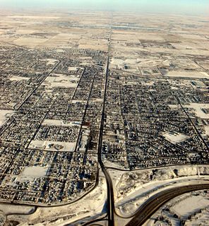
Fort McMurray is an urban service area in the Regional Municipality (RM) of Wood Buffalo in Alberta, Canada. It is located in northeast Alberta, in the middle of the Athabasca oil sands, surrounded by boreal forest. It has played a significant role in the development of the national petroleum industry. The 2016 Fort McMurray wildfire led to the evacuation of its residents and caused widespread damage.
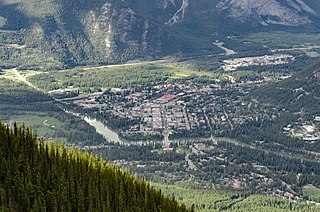
Banff is a town within Banff National Park in Alberta, Canada. It is located in Alberta's Rockies along the Trans-Canada Highway, approximately 126 km (78 mi) west of Calgary and 58 km (36 mi) east of Lake Louise. At 1,400 to 1,630 m above sea level, Banff is the community with the second highest elevation in Alberta, after Lake Louise.
Airdrie is a city in Alberta, Canada within the Calgary Region. It is located north of Calgary within the Calgary–Edmonton Corridor at the intersection of Queen Elizabeth II Highway and Highway 567.

The Municipality of Crowsnest Pass is a specialized municipality in southwest Alberta, Canada. Within the Rocky Mountains adjacent to the eponymous Crowsnest Pass, the municipality formed as a result of the 1979 amalgamation of five municipalities – the Village of Bellevue, the Town of Blairmore, the Town of Coleman, the Village of Frank, and Improvement District No. 5, which included the Hamlet of Hillcrest and numerous other unincorporated communities.
Strathcona County is a specialized municipality in the Edmonton Metropolitan Region within Alberta, Canada between Edmonton and Elk Island National Park. It forms part of Census Division No. 11.

Bowness is a neighbourhood and former town in west Calgary, Alberta, Canada. The former town was amalgamated into the City of Calgary in 1964.

Rocky View County is a municipal district in southern Alberta, Canada that is named for its views of the nearby Rocky Mountains to the west. It surrounds most of Calgary, forming the city's northern boundary and most of the city's western and eastern boundaries. At a population of 39,407 in 2016, Rocky View County is the most populous municipal district in Alberta. Though predominantly rural in nature, Rocky View County is home to 14 hamlets, including Langdon, one of Alberta's most populous hamlets. Its rural areas are home to numerous country residential subdivisions.

André Chabot is a Canadian politician who served as the councillor for Ward 10 of the Calgary City Council. He was elected in a 2005 by-election after Incumbent Margot Aftergood resigned after allegations of a vote rigging scandal surfaced involving mail in ballots from the 2004 Calgary municipal elections.
Jasper Place, originally named West Jasper Place, is a former town in Alberta, Canada now within the City of Edmonton. Prior to amalgamation with Edmonton, the town was bounded by 149 Street to the east, 118 Avenue to the north, 170 Street to the west and the North Saskatchewan River to the south. Its former municipal centre, which included its town hall, fire station and Butler Memorial Park, was located at Stony Plain Road and 157 Street. It was known as West Jasper Place from 1910 to 1950.
Grovedale is a hamlet in northern Alberta, Canada within the Municipal District of Greenview No. 16. It is located on Highway 666 south of Grande Prairie. It is just south of the Wapiti River valley, amidst farmland and ranchland at the northern limits of the boreal forests and aspen parkland in the foothills of the Canadian Rockies.
Albert Park/Radisson Heights is a residential neighbourhood in the southeast quadrant of Calgary, Alberta. It is bounded to the west by the Bow River and Deerfoot Trail, to the north by Memorial Drive and to the south by 17 Avenue SE. The community of Forest Lawn lies to the east.

Forest Lawn High School is a high school in Calgary, Alberta, Canada in the southeast community of Forest Lawn. The senior high school has sports teams, who are known as the Titans, drama productions, dance, band, and choir. The school is located on 44th street, and is near Ernest Morrow Junior High, Jack James Senior High, Bob Bahan Memorial Pool, and Ernie Star Arena.
Beverly is a former urban municipality within the Edmonton Capital Region of Alberta, Canada. Beverly incorporated as a village on March 22, 1913 and became the Town of Beverly on July 13, 1914. It later amalgamated with the City of Edmonton on December 30, 1961. The population of Beverly was 8,969 at the time of amalgamation.

Forest Lawn is a neighbourhood and former town in the southeast quadrant of the city of Calgary, Alberta, Canada. The neighbourhood is bound by 26 Avenue SE to the south, 36 Street SE to the west, 8 Avenue SE to the north and portions of 52 Street SE and 48 Street SE to the east. The former town comprises the entire current Forest Lawn neighbourhood as well as portions of Southview and Albert Park/Radisson Heights to the west, and portions of Penbrooke Meadows and Forest Lawn Industrial to the east. Both the neighbourhood and the former town are bisected by the multicultural 17 Avenue SE. Forest Lawn has an area redevelopment plan in place and is part of the International Avenue Business Revitalization Zone.
17 Avenue SE is a major arterial road in east Calgary, Alberta. 17 Avenue SE is the focal point of the International Avenue Business Revitalization Zone (BRZ) and the main roadway through the former town of Forest Lawn. Chestermere Boulevard is a major arterial road and the eastern extension of 17 Avenue SE through Chestermere, Alberta, Canada. The roadway is a former alignment of Highway 1A.
