
The Castle of Salir is an Almohad fortress, located in the civil parish of the same name, 16 kilometres from the municipality seat of Loulé in the Portuguese Algarve.
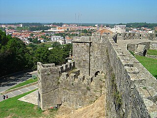
Santa Maria da Feira is a city and a municipality in Aveiro District in Portugal, 23 km from central Porto. The population in 2011 was 139,309, in an area of 215.88 km².

Alcoutim is a town and a municipality in southeastern Portugal near the Portugal–Spain border. The population in 2011 was 2,917, in an area of 575.36 km². It is the least densely populated municipality in Portugal. The municipality is limited on the north by Mértola Municipality, on the east by Huelva Province in Spain, on the southeast by Castro Marim Municipality, on the southwest by Tavira Municipality and on the west by Loulé Municipality and Almodôvar Municipality. The administrative center is the town of Alcoutim, located at the extreme eastern part of the municipality on the Spanish frontier, just across the Guadiana River from the Spanish town of Sanlúcar de Guadiana in Huelva Province. The Moorish Alcoutim Castle, located in the municipality, dates from the 14th century.

Faro District is the southernmost district of Portugal. The area is the same as that of the Algarve region. The administrative centre, or district capital, is the city of Faro.
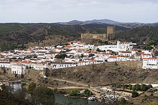
Mértola is a town and municipality in southeastern Portuguese Alentejo near the Spanish border. In 2011, the population was 7,274, in an area of approximately 1,292.87 square kilometres (499.18 sq mi): it is the sixth-largest municipality in Portugal. Meanwhile, it is the second-lowest population centre by density with approximately 5.62 persons/1 square kilometre (0.39 sq mi).

Torres Novas is a Portuguese municipality in the district of Santarém, in the Médio Tejo of the Centro region. The population of the municipality was approximately 36,717, in an area that encompasses 270 square kilometres (100 sq mi). The city of Torres Novas proper has about 15,000 inhabitants in an area located within the municipality.

Lagoa is a city and municipality in the district of Faro, in the Portuguese region of Algarve. The population of the municipality in 2011 was 22,975, in an area of 88.25 km². Its urban population, in the city of Lagoa proper, is 6,100 inhabitants. An important travel destination, its coast has won numerous accolades. Marinha Beach was considered by the Michelin Guide as one of the 10 most beautiful beaches in Europe and as one of the 100 most beautiful beaches in the world.
Feira is a former civil parish in the municipality of Santa Maria da Feira, Portugal. In 2013, the parish merged into the new parish Santa Maria da Feira, Travanca, Sanfins e Espargo. Covering the historic city centre, it is the seat of the Santa Maria da Feira Municipality. It has a population of 11,040 inhabitants and a total area of 8.40 km2. Its demonym is Feirense. While city's official name is Santa Maria da Feira, it is often referred to as simply Feira, including on highway signs. The surrounding area is often known as Terras de Santa Maria.

Sanlúcar de Guadiana is a localidad in the province of Huelva, Andalusia, Spain, situated near the Portugal–Spain border, 50 kilometres (31 mi) from the city of Huelva. The inhabitants are known as Sanluqueños. The village borders the Guadiana River, which is tidal at this point, but the higher parts of the village rise to an altitude of 149 metres (489 ft).

Count of Alcoutim was a Portuguese title of nobility, subsidiary to the one of Marquis of Vila Real, created by a royal decree, dated from November 15, 1496, by King John II of Portugal, and granted to Dom Fernando de Menezes, also known as Ferdinand II of Menezes, 2nd Marquis of Vila Real, 4th Count of Vila Real and 2nd Count of Valença.
Giões is a freguesia (parish) in the municipality of Alcoutim. The population in 2011 was 256, in an area of 71.80 km².

The Castle of Alcoutim is a medieval castle in the civil parish of Alcoutim, in the municipality of the same name, in the southeastern Algarve of Portugal. Built in the 13th century, the castle stands in a dominant position on a hill south of the parish seat of Alcoutim on the right bank of the San Marcos River, opposite the territory of Sanlúcar de Guadiana.
The (Old) Castle of Alcoutim is a medieval castle built onto a prehistoric castro located in the civil parish of Alcoutim, municipality of the same name, in the Portuguese Algarve. About one kilometre (0.62 mi) north of the town of Alcoutim, the old castle is one of the more important Islamic military structures in the Algarve: it is both an important historical visit for tourists and historiographically significant to the Muslim occupation of the region. Commonly confused with the younger Castle of Alcoutim, the old castle was abandoned in the 11th century, but its exploration and excavation was elaborated by archaeologists in the 20th century.
Vila Real is the capital and largest city of the Vila Real District, in the North region, Portugal. It is also the seat of the Douro intermunicipal community and of the Trás-os-Montes e Alto Douro historical province. The Vila Real municipality covers an area of 378.80 square kilometres (146.26 sq mi) and is home to an estimated population of 49,574 (2021), of which about 30,000 live in the urban area (2021).
The Santuario de Santa María de África is a Roman Catholic church in the Spanish city of Ceuta which is located in a small Spanish exclave on the north coast of Africa.

The Castle of the Moors is a hilltop medieval castle located in the central Portuguese civil parish of Santa Maria e São Miguel, in the municipality of Sintra, about 25 km (16 mi) northwest of Lisbon. Built by the Moors in the 8th and 9th centuries, it was an important strategic point during the Reconquista, and was taken by Christian forces after the fall of Lisbon in 1147. It is classified as a National Monument, part of the Sintra Cultural Landscape, a UNESCO World Heritage Site.

The Menhirs of Lavajo are a group of menhirs, located in the civil parish of Alcoutim e Pereiro in the municipality of Alcoutim, Portuguese Algarve.
The Castle of Alva is a medieval castle located in the civil parish of Viade de Baixo e Fervidelas, in the municipality of Freixo de Espada à Cinta, Portuguese district of Bragança.
Infraestruturas de Portugal, S.A. (IP) is a state-owned company which resulted from the merger of Rede Ferroviária Nacional (REFER) and Estradas de Portugal (EP). It manages the Portuguese rail and road infrastructure.

